
PLANNING AND PRACTICE OF THE POLISH-CZECH TRANSBORDER ROAD NETWORK DEVELOPMENT: FROM INEFFECTIVE TOP-DOWN PLANS TO BOTTOM-UP LACK OF COORDINATION?
Marek FURMANKIEWICZ
 *
*
Krzysztof BURYŁO *
Ivo DOSTÁL *
Maria HEŁDAK *
Joanna LIPSA *
Maciej ZATHEY *
Abstract. In this article, the authors analyse the development policy of the major road network in the Polish-Czech border areas in 1958–2024. The methodology of content analysis covering historical bilateral and European planning documents and GIS spatial analysis of access to border areas via roads crossing the border. The analyses have shown: (1) dominance of political and expert planning, without the use of scientific network models; (2) decentralisation of planning and resignation from common documents; (3) prioritising east-west connections and disregarding the north-south European ones; and (4) the greatest increase in border permeability only after the elimination of permanent border controls within the EU Schengen Area since 2007, but mainly due to the opening of historical roads.
Key words: development policy, borderlands, border permeability, road network, spatial planning, European integration, Poland, Czechia.
1. INTRODUCTION
The analysis of border areas development and the impact of the national border on human mobility and economy, including infrastructure, is one of the most classic topics in socioeconomic geography (Minghi, 1963; Prescott, 1965). One of the important issues is the permeability and accessibility of the border and peripheral regions (Hisakawa et al., 2013; Kolejka et al., 2015; Condeço-Melhorado and Christidis, 2018). These characteristics are significantly important for the development of trade and border tourism in these areas (Więckowski, 2010; Michniak et al., 2014). In most countries, the border is a clear barrier that protects countries from an uncontrolled movement of goods and people, and all traffic passing through the designated and tightly controlled border crossings.
In spatial and economic planning in Poland and former Czechoslovakia, during the communist (socialist) period after World War II, border regions were approached as a political and military buffer zone, vulnerable to military aggression in the event of war, and requiring special protection (Ciok, 1990; Bański, 2010; Rychlík, 2016). That trend was much stronger on the border between Czechoslovakia, Western Germany and Austria, where the ‘Iron Curtain’ was erected (Jílek et al., 2006; Mašková and Ripka, 2016). As a result, the number of cross-border road and rail links was deliberately reduced, even eliminating those that existed in earlier historical periods. Restrictions on free movement and settlement in border areas negatively affected the development of transport infrastructure and caused the degradation of the existing one before 1945, especially on the Polish side (Ciok, 1991; Bičík and Štěpánek, 1994; Kołodziejczyk, 2014; Jędruch et al., 2020). These restrictions increased the peripheral character of border areas and their disparities resulting in a negative impact on their development (Ciok, 1990; Vaishar et al., 2013; Kolejka et al., 2015; Böhm and Opioła, 2019; Pászto et al., 2019; Kołodziejczyk, 2020). The widespread censorship of publications and the ‘secret’ status of many planning documents meant that practically until the end of the 1980s, a small number of scientific analyses of the Polish-Czechoslovakian borderland and border cooperation development were carried out (Małecki, 1971; Ciok, 1988). The isolation of the Eastern Bloc countries caused that the analyses of European transport networks until the late 1990s often overlooked Central and Eastern Europe (Gutiérrez and Urban, 1996).
The policy related to borderlands changed only after the collapse of the communist bloc, political transformation of Poland and Czechoslovakia in 1989−1991, and the peaceful division of Czechoslovakia into Czechia and Slovakia in 1993. Reducing restrictions on border traffic and opening local road crossings have had a positive impact on local transborder cooperation and tourism development, although it has not fully eliminated the problem of borderland peripherality (Dołzbłasz, 2017; Furmankiewicz et al., 2020; Piepiora et al., 2021; Sikorski et al., 2023; Furmankiewicz and Trnková, 2024). The accession of Poland and Czechia to the European Union (EU) in 2004 and to the Schengen area in the end of 2007 was of particular importance, when permanent border controls were abandoned (Jańczak, 2014; Directorate-General for Migration and Home Affairs, 2015).
The democratisation of Central and Eastern Europe countries and the processes of European integration have made it more common in the 21st century to analyse transportation problems on a European-wide scale (Christodoulou and Christidis, 2019; Goldmann and Wessel, 2020; Pérez-Acebo et al., 2021), as well as in Central and Eastern Europe (Fleischer, 2003; Koziarski, 2020; Komornicki and Goliszek, 2023). Several authors have also carried out basic analyses of the transport network development in the Polish-Czech borderland (Kolejka et al., 2015; Kołodziejczyk, 2020), although historical planning documents and their actual implementation in investment practice have frequently not been thoroughly analysed or evaluated.
In this article, the authors analyse the historical development of road network planning in the Polish-Czech borderland and the Polish-Czech (former Polish-Czechoslovakian) cooperation in this area covering 1958–2024. However, the focus is on the investments in 1991−2024, when the development of the cross-border road network was at its greatest dynamics after many years of stagnation. The following main research questions (RQ) about the borderland under analysis were considered:
- (RQ1) What main stages of cooperation in planning road networks in this area can be identified?
- (RQ2) How do the studied area road network plans fit into the European road network policy?
- (RQ3) Were the plans based on methodical analyses of road network efficiency or were they primarily influenced by the central government policy or local and regional lobbying efforts?
- (RQ4) To what extent were the agreed plans for the development of cross-border connections implemented and how did it affect the permeability of the border for cars?
In Section 2 of the article, the research methods of and the territorial scope of the study are described. Section 3 presents how the current Polish-Czech borderland was considered in pan-European and national documents with a focus on the road network, mainly addressing RQ2 and, to a lesser extent, RQ1 and RQ3. In Section 4, the authors conduct a qualitative analysis of common public strategic and planning documents taking into account the development of the road network in the studied area (the study related primarily to RQ1, less to RQ2 and 3). Next, based on cartographic materials, the changes in the road network layout (national and international) are presented and the permeability of the border in terms of car traffic (paved roads of all categories open to car traffic) in 1991−2024 (GIS analysis focusing on RQ4). The conducted analysis may be useful for researchers and public authorities involved in spatial analysis and planning in border regions, particularly in countries at the initial stages of economic integration.
2. MATERIALS AND METHODS
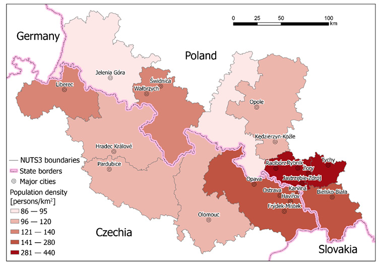
The detailed analysis presented in this article covers the current Polish-Czech border and adjacent border areas, defined as EU NUTS-3 statistical units according to the classification effective as of 1 January 2018, including the areas located at least 30 km from the border (Fig. 1). This is due to the fact that Poland had a 30-kilometer border zone with various types of restrictions related to the protection of the state border which were later relaxed or completely eliminated.
Source: prepared by J. Lipsa, based on data in Table 1.
The current length of the Polish-Czech border is approximately 796 km. It was a fragment of the Polish-Czechoslovakian border (1945−1992, and only short fragment 1920−1992) and the Polish-Czech border from 1993. The western and central part of the border includes the Sudetes mountain region (Krkonošsko-jesenická subprovincie/ Sudety/ Sudeten), while the eastern part includes the densely populated areas of Silesia and a small fragment of the Carpathian massif (Kolejka et al., 2015; Furmankiewicz et al., 2020). The analysed area covers 46.9 thousand square kilometres, of which 23.8 thousand sq. km in Poland and 23.1 thousand sq. km in Czechia (Table 1). The area has a population of 7 million (31.12.2023), including 3.7 million in Poland and 3.3 million in the Czechia. The population decreased by 4% between 2004 and 2023.
| NUTS-3 region name | Eurostat Code | Area [sq. km] in 2023 |
Population (CZ-1991; PL-1995)* | Population 31.12.2004 | Population 31.12.2023 |
|---|---|---|---|---|---|
| Liberecký kraj | CZ 051 | 3,163 | 425,120 | 427,722 | 449,177 |
| Královéhradecký kraj | CZ 052 | 4,758 | 552,809 | 547,563 | 555,267 |
| Pardubický kraj | CZ 053 | 4,519 | 508,718 | 505,486 | 528,761 |
| Olomoucký kraj | CZ 071 | 5,160 | 647,391 | 636,313 | 631,802 |
| Moravskoslezský kraj | CZ 080 | 5,535 | 1,278,726 | 1,260,277 | 1,189,674 |
| Jeleniogórski | PL 515 | 5,569 | 616,602 | 586,147 | 530,718 |
| Wałbrzyski | PL 517 | 4,181 | 741,624 | 691,079 | 605,614 |
| Nyski | PL 523 | 4,092 | 406,531 | 395,031 | 350,225 |
| Opolski | PL 524 | 5,319 | 686,641 | 656,500 | 586,500 |
| Rybnicki | PL 227 | 1,353 | 667,699 | 641,861 | 601,229 |
| Tyski | PL 22C | 944 | 385,606 | 382,173 | 392,267 |
| Bielski | PL 225 | 2,352 | 640,557 | 646,166 | 655,213 |
| Total in Czechia | no data | 23,144 | 3,412,764 | 3,377,361 | 3,354,681 |
| Total in Poland | no data | 23,810 | 4,145,260 | 3,998,957 | 3,721,766 |
| Total in studied area | no data | 46,954 | ~7,558,024 | 7,376,318 | 7,076,447 |
* The NUTS classification used in the EU was formally introduced in Czechia (CZ) on 1 January 2000 and in Poland (PL) on 26 November 2005 and not all data were available back then.
Source: own work based on: Poland, Bank Danych Lokalnych GUS [Local Data Bank Statistics Poland] (https://bdl.stat.gov.pl); Czechia, Český statistický úřad: Statistická ročenka České republiky 2004, Statistická ročenka České republiky 2023; Statistický lexikon obcí 2024.
In Sections 3 and 4, the authors analyse historical planning documents as well as cartographic materials collected through searches in public libraries and offices in Poland and Czechia, and in the Internet databases, the most important of which are listed in Appendices 1 and 2. In Section 4 the focus is on bilateral documents created in cooperation between Polish administration units and partners from Czechoslovakia (until 1992) and Czechia[1] (from 1993) at the national or regional level. The analysis covers only ancillary data on cooperation at the sub-regional level of the Euroregions and European Groupings of Territorial Cooperation (EGTC). The Euroregions and EGTC do not have the authority to plan the road network and can only conduct lobbying activities (Furmankiewicz, 2007; Skorupska, 2018; Lewkowicz, 2019). These sections use a classic qualitative, descriptive content analysis (Neuendorf, 2002; Denzin and Lincoln, 2018), commonly practised in the planning policy and cartographic material historical analysis (Fleischer, 2003; Bański, 2010; Böhm and Šmída, 2019). The information on plans for the development of automobile cross-border roads connecting the areas on both sides of the border, as well as information on planned and historically opened automobile border crossings was searched for in the documents. The Polish-Czechoslovakian agreement on the final demarcation of the border after World War II was signed only in 1958 (its subsequent corrections were minor); therefore, the presented analysis of borderland planning policy begins from that period.
In Section 5, an ArcGIS analysis of the border areas accessibility through border crossings[2] (Kwon and Graham, 2021) was performed. The input layers used were point layers representing border crossings in 1991 and places accessible for car crossing in 2024, as well as a linear layer with a network of roads accessible to cars, specific to each year. The lists of border crossings accessible to public car traffic from the documents listed in Appendices 2 and 3 were used. Other types of border crossings that restricted car crossings for Polish and Czech citizens were deliberately omitted (including, e.g., tourist hiking, cycling, and skiing border crossings, as well as local border traffic crossings restricted to residents of border municipalities with individual passes).
The historical development of cross-border road networks from 1991 to 2024 was identified using cartographic material: traditional road maps, topographic maps, orthophoto maps, the OpenStreetMap database, and Google Street View. The data on the road network was used not considering local restrictions on vehicle tonnage (data not available in historical cartographic materials). In Poland a formal differentiation between ‘motorway’ (autostrada) and ‘expressway’ (droga ekspresowa) was introduced in 1993, which differ in technical parameters and maximum allowed speeds. In Czechia, the different categories of ‘motorway’ (dálnice) and ‘road for motor vehicles’ (silnice pro motorová vozidla) have been present since 2016.
The weakness of our border permeability analyses is the focus on publicly accessible border crossings for vehicles (small border traffic crossings and crossings on tourist routes were excluded from the analysis) and the failure to consider various restrictions in place at these crossings (e.g., limited opening hours of the crossing or the restrictions for citizens of other countries). However, such simplifications are necessary to ensure the feasibility of the research.
3. ROAD NETWORK IN THE POLISH-CZECH BORDERLAND IN NATIONAL AND EUROPEAN DOCUMENTS
The first planned modern long-distance road transport link in the studied area was the German A88 motorway (Breslau–Wien), the concept of which was included in the Munich Agreement of 1938, however, it was not constructed until the end of World War II in 1945 (Janda and Lídl, 2008; Dostál et al., 2023).
After the war followed changes in the national borders of Czechoslovakia and, to a greater extent, Poland, imposed by the major powers of the anti-Hitler coalition at the Yalta conference. As a result, part of the former Czechoslovak-German border became the Czechoslovak-Polish border in 1945 (Eberhardt, 2017). Only a small portion of the former Polish-Czechoslovak border near Cieszyn was preserved in the studied area. Undemocratic one-party communist systems under the control of the Soviet Union were imposed in both countries. The movement of people across the border was limited and strictly controlled (Komornicki, 1990; Rychlík, 2016).
After World War II, the first general plans for the construction of motorways appeared in both countries, focussing on internal connections between the main cities (Prášil, 2007; Kalinowski, 2021). The first concept of a unified system of international roads in Europe, which included Poland and Czechoslovakia, was prepared as early as 1950 as part of a declaration by the United Nations Economic Commission for Europe – UNECE (United Nations, 1951). During that period, three roads of international importance were agreed in the analysed area: E12 (Paris – Praha – Hradec Králové – Słone – Kłodzko – Wrocław – Warszawa – Leningrad (currently Sankt Petersburg) and Moscow), E14 (Trieste – Praha – Mladá Boleslav – Jelenia Góra – Szczecin), and E16 (Bratislava – Žilina – Český Těšín – Cieszyn – Katowice – Gdańsk). These roads included major international passport-border crossings along historical routes.
Plans for motorways, which were similar in terms of the routes Wrocław – Wałbrzych (PL) – (probably Lubawka) – Hradec Králové (CZ) – Praha and Katowice – Rybnik (PL) – Ostrava (CZ), were prepared in 1963, both in Poland and Czechoslovakia (Fig. 2). In Czechoslovakia it included the D11 (E12) motorway link Praha – Hradec Králové – border of Poland (via Lubawka, alternatively via Náchod), and the D47 (E7) motorway from the Brno region via Ostrava to the border of Poland while the E14 through Harrachov (CZ) – Jakuszyce (PL) and E16 through the Český Těšín (CZ) – Cieszyn (PL) border crossings were decided to be preserved as the first class roads (Prášil, 2007). Similarly, in Poland, the project of ‘express roads’ was approved, including the Wrocław – Wałbrzych – Praha (CZ) and Katowice – Rybnik – Wien (Austria) roads (Rustecki,1965; Kalinowski, 2021).
These plans were retained in the Polish motorway construction plan in 1972 (Kaliński, 2021, p. 412), and in Czechoslovakian plans from 1971 (Prášil, 2007, p. 22). The road plans intended to connect the largest cities were drawn very schematically, often with straight lines or arcs. However, neither of the trans-border motorways were prioritised and they were not built before 1992.
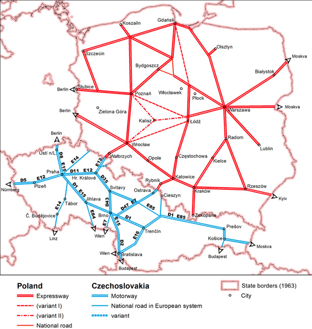
Source: prepared by I. Dostál, based on Prášil (2007, p. 13) and Rustecki (1965, p. 94).
In 1975, the European Declaration of the UNECE was replaced by the European Agreement on Main International Traffic Arteries (United Nations, 2007, 2008). The layout of international roads crossing the Polish-Czech border has not changed significantly (Fig. 3). Only different road markings have been introduced and extended beyond the area of our analysis (E14 to E65, E12 to E67, E16 to E75). The 1985 Polish plan for the construction of motorways and expressways took into account earlier plans (expressway from Legnica and Wrocław to Praha; motorway Katowice – Wien) and additionally included the Katowice and Bielsko-Biala – Cieszyn expressway in the direction of Ostrava (Kaliński, 2021, p. 420).
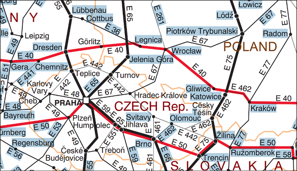
Source: © United Nations (2007), https://digitallibrary.un.org, downloaded on 22.08.2024.
The economic crisis of the 1980s contributed to the dissolution of the Soviet Union, the collapse of the political socialist bloc in Europe, and the introduction of democratic systems in most eastern European countries. After 1990, the restrictions in border areas were gradually lifted. These changes contributed to an increase in local and international cross-border traffic through road border crossings in the studied area (Komornicki, 1999). The interest of local authorities in the development of trans-border road communication in the area under analysis has also increased (Furmankiewicz, 2007; Kolejka et al., 2015; Kurowska-Pysz and Szczepańska-Woszczyna, 2017). In 1989, on the initiative of the European Commission, the PHARE (Poland and Hungary Assistance in Restructuring Economies) programme was established, which envisaged financial assistance from the European Communities to Central and Eastern European countries, including road infrastructure (Zdulski, 2002).
An important planning activity for long-distance transport links in Europe (including the former Eastern Bloc countries) was the proposal of the so-called Pan-European Corridors (PEC) at the European Conference of Ministers of Transport[3]. The 1991 Prague (Praha) conference defined the original concept of corridors and determined the necessary level of transportation infrastructure. Poland adopted a national motorways construction plan in 1993.
At the following two conferences: in Crete (1994) and Helsinki (1997), ten corridors were finally defined (Stancu et al., 2014). It was recommended that they be given investment priority due to their role in connecting the internal European market and building ties with neighbouring countries (TINA Office, 2002; Miltiadou et al., 2017; Czech, 2021). An offshoot of the planned corridor No. 6 crossed the Polish-Czech border in its eastern part (Gdańsk – Katowice – Ostrava – Brno). However, the main corridors No. 3 and 4 ran parallel to the borderland (Fig. 4). Compared to the 1975 findings, this concept can be considered a regression, as it excluded two international roads: E65 and E67, which were not considered relevant at all.
Road planning was influenced by administrative reforms in both countries. In Poland, self-governing regions (województwa) and districts (powiaty) had been established since 1999. Consequently, a deconcentration of responsibility for planning, investment and maintenance of roads took effect. One year later, self-governing regions (kraje) were also introduced in Czechia.
The simultaneous accession of Poland and Czechia into the EU in 2004 was of great importance for the development of local road network in the borderland (which involved the elimination of customs controls at border crossings), followed by the accession of both countries to the Schengen area in 2007 (lifting permanent passport controls and permitting free border movement). This enabled the opening of local roads to pedestrian and automobile traffic and enabled access to the EU aid funds for infrastructure development (Dołzbłasz and Raczyk, 2015; Kulczyk-Dynowska, 2018; Kachniarz et al., 2019; Przybyła et al., 2020).
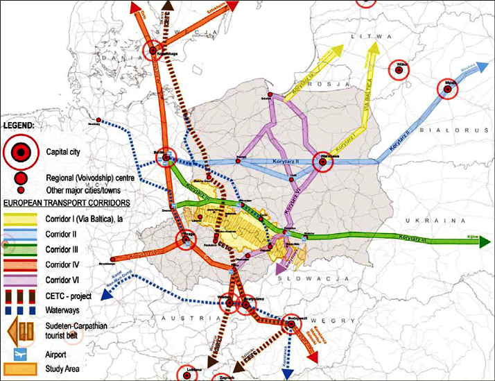
After the EU enlargement in 2004–2006, work began on the EU Trans-European Transport Network (TEN-T) to include the new Member States. At that time, several local and regional authorities in Sweden, Slovakia, Hungary, Croatia, Poland, and Czechia formulated an independent and grassroots concept of the Central European Transport Corridor (CETC) (Chwesiuk, 2006; Zathey, 2009, 2010). It was to run between the Skåne region in Sweden through Świnoujście (PL) in the Baltic Sea and Rijeka (Croatia) in the Adriatic Sea, through Legnica (PL) and Hradec Králové (CZ) (Fig. 4) (CESCI, 2010).
Between 2004 and 2009, a joint secretariat was established for the initiative, and lobbying activities were conducted in the EU. On 28 June 2010, the Szczecin Declaration on CETC development was announced. The entire CETC was eventually not included in the ‘core EU network’. However, the Legnica (PL) – Pardubice (CZ) connection through Lubawka (PL) was listed in the UNECE plans (UNECE, 2012) and in the EU Regulation No. 1315/2013 as a ‘core network route to be upgraded’ (Fig. 5) (The European Parliament and The Council of the European Union, 2013a, pp. 31, 51). However, it was not listed as the most important for the EU in Regulation 1316/2013 on the establishment of the Connecting Europe Facility (The European Parliament and the Council of the European Union, 2013b). The omission of the Pardubice – Brno connection in this document does not facilitate the dispersion of north-south European traffic, which would continue to be concentrated through the Moravian Gate and Upper Silesia (Ostrava – Katowice connections) or through eastern Germany.
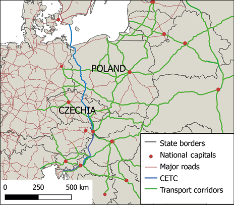
Source: prepared by J. Lipsa, based on: Fleischer (2003), Talberg and Belof (2010), and Stancu et al. (2014).
Source: The European Parliament and the Council of the European Union (2013a, p. 51).
The spatial planning system introduced in Czechia in 2006 established a new hierarchy of planning documents. At the top is the Spatial Development Policy (PÚR – Politika územního rozvoje), which defines the requirements for spatial planning processes and also outlines the most important development axes and infrastructure corridors. The main planning document at the regional level is the Principles of Spatial Development (ZÚR – Zásady územního rozvoje) for individual NUTS-3 regions. These specify the details of the corridors defined at the national level and also add provincial road plans.
The first edition of PÚR in 2008 confirmed the connection D11 between Hradec Králové (CZ) and Legnica (PL) in the form of an expressway, while the D1 corridor through Ostrava was considered operational (individual sections were completed from 2007 to 2009) despite the fact that the cross-border section between Bohumín (CZ) and Gorzyczki (PL) was not opened to traffic before 2012. A new element in spatial planning is the ‘corridor of a capacity road’ (not necessarily a motorway or expressway) S1 between Mohelnice and the Polish border via Šumperk and Jeseník. It was intended to ensure a quality connection of the Jeseník area to the rest of the country and to promote tourism in this marginalised region. The PÚR has been updated seven times since 2008 with another actualisation in progress. Following the update of the European TEN-T corridors, the corridor of the motorway D48 Bělotín (D1) – Frýdek-Místek – Český Těšín (– Kraków) was added in 2015. However, the aforementioned corridor S1 was removed from the concept in the same update after stabilising the corridor in the regional ZÚR and with the task of defining it in more detail for the lower stages of spatial planning. This document for the Olomoucký kraj specifies the S1 corridor along the existing national road I/44 including the tunnel under the Červenohorské sedlo pass and with an expected border crossing in the area of Mikulovice (CZ) and Głuchołazy (PL) (Ptáček et al., 2015).
In 2019, an amendment to the regulation on the network of motorways and expressways in Poland was published, which provides for the extension of the S5 expressway on the Wrocław – Sobótka – Świdnica – Bolków (S3) section in the studied area, and the extension of the S8 expressway on the Wrocław – Kobierzyce – Łagiewniki – Kłodzko section. The possible continuation of S8 to the border near Boboszów was included in the national road network development plan in 2022. However, in Czech planning documents, this expressway has no continuity. Only the ZÚR of Pardubický kraj proposed a corridor for the modern two-lane relocation of the I/43 road with bypasses and even that does not have a high priority in development plans.
4. POLISH-CZECH COOPERATION IN PLANNING THE ROAD NETWORK IN THE BORDERLAND
In the postwar period, the Polish-Czechoslovak border areas suffered from restrictions on movement, residence, and investment typical of the communist system. The border areas were guarded by the Border Protection Army (Ciok, 1991; Kołodziejczyk, 2014).
The legitimacy of cooperation in the field of spatial planning in the Polish-Czech borderlands, including the road network, was first highlighted in 1959–1962 based on the mutual border treaty signed in 1958, when meetings of working teams were held involving representatives of both countries. At that time, it was agreed to build a motorway Ostrava (CZ) – Katowice (PL), and to reserve land for future construction of the border divided city Cieszyn/Český Těšín bypass (Małecki, 1971). In 1955, 1959, and 1961 Poland and Czechoslovakia signed agreements on cross-border tourist traffic, small border traffic and ‘tourist convention’ in the Karkonosze/Krkonoše Mountains, but these initiatives had no impact on the development of the main road network or on the opening of publicly accessible motor road border crossings. Consultations ceased after the armed intervention of Warsaw Pact troops (including Polish forces) in Czechoslovakia in 1968, which occurred during the efforts to implement democratic reforms. It was not until the late 1970s that wider Polish-Czechoslovakian cooperation began again, with the formation of the ‘Temporary Commission for the Development of a Long-Term Concept for the Development of Border Regions’. However, the cooperation was again interrupted after the imposition of martial law in Poland in 1981–1983 following social protests against the communist authorities.
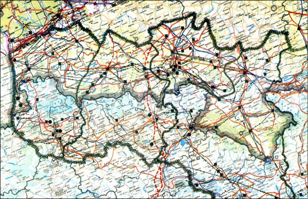
The cooperation was resumed in the mid-1980s. The first joint document entitled Study of Spatial Development of Border Areas of the Poland–Czechoslovakia was approved by both sides in 1985 (Łysak et al., 1985). The study was dominated by environmental issues, while socioeconomic development problems occupied relatively little space. At the time, the construction of two roads in the north-south direction was maintained: Ostrava (CZ) – Katowice (PL) and Hradec Králové (CZ) – Legnica (PL). The opening of 10 new local road border crossings was planned to facilitate movement for local residents (finally opened in subsequent years, however, only for constrained local movement for local inhabitants with individual passes). The document was not made available to the public, was not publicly consulted, and had a ‘confidential’ status – ‘exclusively for official use by state institutions.’ The borderland development maps prepared there on a scale of 1:200,000 were schematic, of poor cartographic quality, often distorted and poorly agreed on – for example, on the borderland development map prepared, the planned Ostrava – Katowice motorway reached the border in different places on the Czech and Polish sides (Fig. 6). This document was consistent with the national plan adopted in Poland in 1985 (Kalinowski, 2021, p. 420).
The democratic transition in Poland and Czechoslovakia in 1989–1991 caused politicians to focus on domestic issues and temporarily reduce cooperation. However, new contacts began as early as 1991, continued after the peaceful division of Czechoslovakia into Czechia and Slovakia (as of 1 January 1993), and in 1993 a joint Coordination Study of the Development of the Polish-Czech Borderland was prepared (Borsa et al., 1993). In that document, the low parameters of the transit roads and the poor development of international importance links were identified as the main communication problems (the border area lacked motorways and expressways that crossed that border at the time). The need for Ostrava (CZ) – Katowice (PL) and Hradec Králové (CZ) – Lubawka (PL) – Legnica motorways was confirmed at the time, pointing out the lack of any international agreement in this regard. Attention was also drawn to the need to open new local border crossings. The cartographic appendices were prepared on a 1:500 000 map base. The planned border and cross-border infrastructure was drawn by hand (Fig. 7), but the quality of the study is higher than that of the 1985 document. In a democratic system, the document became publicly available, although it was distributed in a limited number of paper copies. In 1996, it was decided to update the Coordination Study (...), which was completed and published in 1997. This study took into account, i.a., changes in the number of border crossings.
By the time the update was prepared, the EU pre-accession funds under the PHARE CBC Programme had already begun to be used, which could also be spent on the development of cross-border road infrastructure (Zdulski, 2002). One of the initial programming materials, which referred to the earlier and updated Coordination Study (...), was the Development Strategy for the Polish-Czech Borderland, which was then used for the development of the Joint Programming Document for cross-border cooperation. Both documents, published in 2000, identified cross-border development priorities in the economic, environmental, and social spheres in border areas (Belof, 2006; Borsa, 2015). The strategy includes a short statement on the need to support the development of the Wrocław – Kłodzko (PL) – Brno (CZ) connection (Borsa, 2000).
Source: Polish-Czechoslovakian common official document signed 30.10.1985 in Pokrzywna; see: Łysak et al. (1985).
Source: Polish-Czech common official document signed 30.11.1993 in Wałbrzych;
see: Borsa et al. (1993).
In 2002−2006, a document was prepared entitled A Study of Spatial Development in the Polish-Czech Borderland. The Synthesis of National Documents, based on other national Polish and Czech material (Belof, 2006; Polański, 2006)[4]. It was noted that the two main European transport corridors (III, leading from Germany through Poland to Ukraine) and IV (leading from Germany through Czechia to Slovakia) have a roughly parallel layout on both sides of the Polish-Czech borderland, thus relatively easily accessible in terms of transport, despite being located on the sidelines of the main transport corridors. According to the document, this facilitates the development of the ‘Sudetes–Carpathian tourist belt’. Only corridor VI (which leads from Austria through Czechia to Poland) crosses the border in the heavily industrialised and densely populated areas of Moravia and Silesia in the eastern part of the studied area (Fig. 8). The study also highlights the efforts of regional and local governments to build the Central European Transport Corridor (CETC) to connect Scandinavia through the Szczecin/Świnoujście ports complex (PL) and the western part of Poland with Czechia and southern Europe (along the route of the Hradec Králové – Legnica expressway, planned since the 1960s).
The 2006 document adopted an additional division of roads (relative to the one used in 1993 and 1997) into the ‘internally’ (inside the common Polish-Czech border area) and ‘externally’ (transit) significant routes. The following key international routes were mentioned: E40, E65, E67, E75, as well as the national road No. 45 (PL) and the D1 (ex D47) motorway (CZ). Undoubtedly, these are the routes that form the most important road connections, providing communication both within the studied area and with neighbouring regions and the rest of Europe. Most of these major arteries were modernised or at least maintained in good technical condition between 2006 and 2024.
Source: courtesy of Institute of Territorial Development, Wrocław, Poland; see: Polański, 2006, p. 44.
After 2006, there was no coordinated planning document for the comprehensive development of road infrastructure throughout the Polish-Czech borderland. The INTERREG cross-border programmes assumed a minor role in coordinating the development of transport infrastructure at the local and regional levels, implemented since Poland and the Czechia joined the EU in 2004. Successive editions of the programme allowed the development of road infrastructure and the modernisation of existing road sections, but apart from the extremely general formulation of the priority tasks that would receive funding, they did not include rational plans for the development of the road network and cross-border connections (Table 2).
| No. | Name of INTERREG programme | Priorities in documents that relate directly to the borderland |
|---|---|---|
| 1. | Community Initiative INTERREG IIIA Czech Republic – Poland 2004–2006 | Priority 1: Further development and modernisation of the infrastructure to increase the competitiveness of the border area. Measure 1.1: Supporting the development of infrastructure of cross-border importance. |
| 2. | INTERREG Cross-border Cooperation Programme Czech Republic – Republic of Poland 2007–2013 | Priority axis 1: Strengthening communication accessibility, environmental protection, risk prevention. Areas of support: Strengthening communication accessibility; Improving the state of communication infrastructure and the state of transportation services in the Polish-Czech border area. |
| 3. | INTERREG V-A Czech Republic – Poland 2014−2020 | Priority axis 2: Development of natural and cultural potential to support employment. The document includes infrastructure measures for the accessibility and use of cultural and natural heritage across borders. The projects could support road links that improve cross-border accessibility and increase the attractiveness of cultural and natural resources, leading to increased visitation and thus improving the cross-border labour market. |
| 4. | Czechia – Poland INTERREG Programme 2021–2027 | Priority 3: Transport Measure: Develop and improve sustainable, climate resilient, intelligent, and intermodal mobility at the national, regional, and local levels, including improved access to TEN-T and cross-border mobility. |
Source: own work based on INTERREG programme documents.
INTERREG funds enabled significant investments in local roads and also in provincial roads that were in the area of support. However, these projects were usually the result of the individual capacity to prepare investment projects and the lobbying activities of local and regional governments (Dołzbłasz and Raczyk, 2024). In the analysed area, on the Polish side, INTERREG projects focused on the development of the area along the Pan-European Transport Corridor 3 (Berlin/Dresden – Wrocław – Kraków – Lviv – Kyiv) (Sieradzka-Stasiak, 2012). Only the project ‘EDCIII Via Regia’ implemented under the INTERREG III B CADSES Community Initiative (2005−2008), which involved 16 partners from Germany, Poland, Czechia, Slovakia and Ukraine, also included a study for the possible Wrocław – Kłodzko – Międzylesie – Boboszów expressway in Poland. On the Czech side, a similar study was created covering the area from the Międzylesie Pass to Brno. However, due to the focus on the development of Corridor 3, the next edition of this programme – ‘Via Regia Plus’ (2008–2011) – did not include Czech partners. In 2014, with the support of the EU, the European Groupings of Territorial Cooperation (EGTC) ‘Central European Transport Corridor’ was established with its headquarters in Szczecin (Poland), but no Czech partner joined this organisation, even though the corridor was to run through that country (the partners came from Sweden, Poland, Hungary, and Croatia).
During the 2014–2020 EU programming period, to obtain the EU funds, regions and central institutions were required to have transport infrastructure development plans. However, there was no demand to use scientific models for the development of the network. For example, in 2014, the ‘Strategy for Integrated Cooperation of the Czech-Polish Borderland 2014–2020’ was created (ARLEG and CIRI, 2014), covering border areas in Lower Silesia and four adjacent Czech regions. It was a very simplified document that did not adopt any measurable goals. In terms of the road network, strategic objective 2.1 was ‘Sufficient transport accessibility and cross-border mobility’ without any spatial analysis or recommendations. The problems of transport and road development were also raised in the documents by the Euroregions and EGTC (territorial forms of trans-border cooperation of regional and local governments), but apart from lobbying activities toward authorities at various levels, they have no competence to plan road infrastructure.
Beyond that, no new coordinated Polish-Czech plans for borderland development were prepared. Central institutions (Ministries, the General Directorate for National Roads and Motorways, and the Road and Motorway Administration in Czechia) signed only individual agreements on the expansion of international roads of national importance (e.g., the continuation of the Polish S3 route as part of the Czech D11 motorway was confirmed).
5. ANALYSIS OF THE DEVELOPMENT OF TRANS-BORDER ROADS
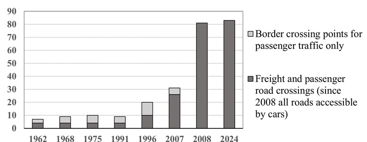
In 1962−1991, the border permeability was low. There were only between 7 and 10 road border crossings accessible by cars open on the studied border (Fig. 9); however, only four of them were open to all passengers, whereas the others were typically open only to citizens of the seven socialist countries specified in the regulation (Poland, Czechoslovakia, East Germany, USSR, Romania, Bulgaria, Hungary). In 1991, these border crossings were opened to citizens from all countries.
Within the framework of the funds provided by several PHARE programmes, since 1994 a number of road investments important to cross-border automobile traffic have been subsidised in Poland, e.g., the construction of bypasses for towns (e.g., Lubrza, Prudnik, Kamienna Góra) or the modernisation of international roads (e.g. slow lane Lewin Kłodzki – Duszniki Zdrój). In 1991, a new border crossing was opened between Český Těšín and Cieszyn on the city ring road to relieve two one-way border crossings through the city centre.
Source: own work.
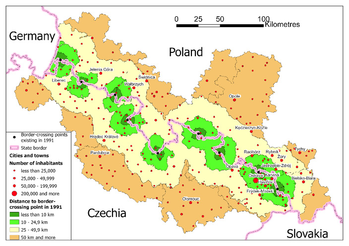
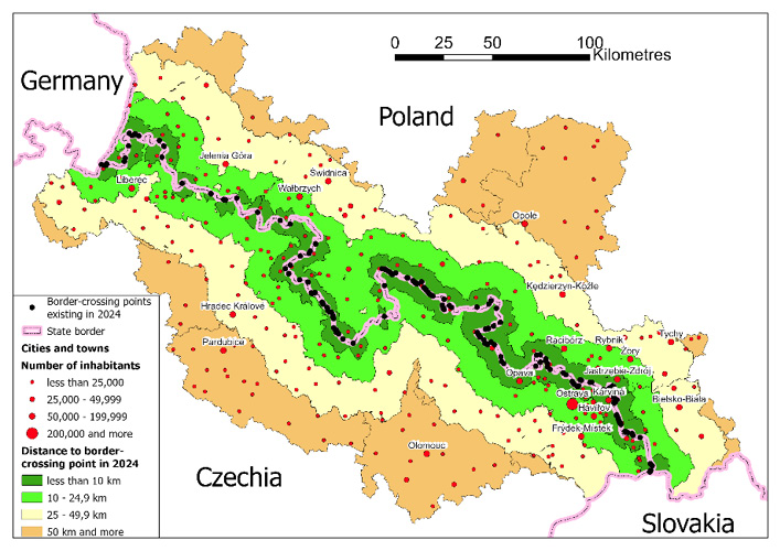
Since 1996, 20 road border crossings have been accessible to cars on the analysed border[5], approximately half of which had some restrictions on freight traffic. Therefore, the permeability of the border has doubled as compared to 1991. Additionally, about 37 local border traffic crossings and 24 crossings on tourist routes excluded from car traffic were opened. Poland and Czechia joined the EU in 2004. As a result, customs controls at the border crossing were eliminated. Only passport control was left. There were 11 new passport border crossing opened for cars in 1997−2007, reaching 31 crossing points (Appendix 3), when Poland and Czechia joined the so-called Schengen zone of the EU on 21 December 2007. As a result, permanent passport controls were abolished, freedom of crossing the state border was implemented and crossing the border with a motor vehicle was allowed on all roads crossing the border where no special restrictions on vehicle traffic had been imposed. The border permeability increased significantly, allowing free local and tourist traffic through local roads (Fig. 10).
|
A) 1991 |
|
|
B) 2024 |
|
Source: prepared by K. Buryło.
After the border was opened, a motorway connection (as part of the TEN-T corridor) was built on the E75 route (A1 motorway) Ostrava (CZ) – Katowice (PL), with the border crossing Bohumín (CZ) – Gorzyczki (PL). It was opened to car traffic in 2012 and freight traffic from 2014. However, in general, after 2008 the border permeability did not improve significantly due to limited cross-border investments. Between 2015 and 2024, the construction of the S3 motorway was completed in Poland (route Legnica – Lubawka, plans for which appeared in Polish-Czechoslovak agreements as early as the 1960s). However, on the Czech side, its completion was planned later (Fig. 11).
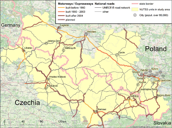
(only the main international and national roads in the studied area were shown)
Source: prepared by I. Dostál, based on data from: General Directorate for Roads and Motorways, Poland; Roads and Motorways Directorate, Czechia; and OpenStreetMap.
6. DISCUSSION AND CONCLUSIONS
The presented analyses enables one to distinguish the following historical periods of development of the road network and cooperation in coordinating its expansion (answer to RQ1):
- Period 1945–1957: After the postwar period of chaos, the borders were gradually closed and protected by the Border Protection Army (existing until 1991 in Poland). Territorial Polish-Czechoslovakian disputes further hampered cooperation in spatial planning.
- Period 1958−1978: Under pressure from the Soviet Union, Poland and Czechoslovakia signed an agreement on the final demarcation of the border in 1958. As a result, in 1961, part of the Sudetes were included in the so-called convention on tourist traffic. However, only 7 to 10 public motor crossings were functioning. Many other local cross-border roads were gradually destroyed or blocked. In 1963, in both countries relatively coherent plans were created for the construction of two main cross-border motorways. However, the coordination of borderland spatial planning was very poor.
- Period 1979–1992: In 1979, the Intergovernmental Commission for the Development of Border Regions was formally established, and this time the development of cooperation between central planning institutions was initiated, which contributed to the first joint Polish-Czechoslovakian coordination document in 1985. However, apart from the preparation of a common document (although confidential), no significant infrastructure investments in cross-border roads were implemented and the border permeability for cars was not practically increased, except partial relaxation of movement restrictions for locals within the ‘small border regime’, especially after democratic transformation in both countries in 1989−1991. The number of standard motor vehicle border crossings remained largely unchanged until 1996.
- Period 1993–2007: After the peaceful division of Czechoslovakia into Czechia and Slovakia in 1993, Polish-Czech cooperation was developed in the field of spatial planning in border areas, resulting in the adoption of several common documents on borderland development (1993, 1996, 2000, and in 2006). The planning of cross-border connections continued to be coordinated at the central level. However, lobbying efforts by local governments of border municipalities, Euroregions, and regional self-government (since 1999 in Poland and since 2000 in Czechia) for the expansion of local cross-border transport links have become of great importance. In 2004, Poland and the Czechia joined the EU, which, however, initially did not significantly increase the border permeability for passenger traffic. During this period, a significant number of local border roads were repaired, subsidised by the PHARE pre-accession funds, and EU INTERREG funds.
- Period 2007 (December)–2024: After Poland and Czechia joined the EU Schengen area, the borders were fully opened (abolishing permanent passport controls) on 21 December 2007, significantly increasing the border permeability (from 31 motor, passport border crossings to about 80 open transborder roads). Central cooperation in planning border areas (in addition to coordinating major international roads) disappeared, with the planning dominated by regional authorities focused on their own areas. With the support of the EU funds, the cross-border connection within Corridor 6 Ostrava (CZ) – Katowice (PL) was completed in 2012–2014, as well as the Bielsko-Biała (PL) – Cieszyn/Český Těšín – Frýdek-Místek (CZ) expressway (S1 – originally as S52 – in Poland, D48 – formerly expressway R48 – in Czechia), and expansion and upgrade of many other local roads was carried out. However, no higher-category roads were completed in the Sudetes (the Polish S8 ends at the border and has no continuation in Czechia in 2024). The idea of CETC corridor in Czechia was not supported either (no planned motorway Moravská Třebová – Brno until 2030).
Planning processes also show a shift away from the coordination of border cooperation by central authorities and an increased role for regional authorities in planning the development of border areas, but this has reduced Polish-Czech coordination in planning cross-border roads in the long term and can negatively affect the overall efficiency of transport network in border areas.
In communist (socialist) times, cooperation in road network planning was poor and plans to build higher-category cross-border roads were not implemented at all in practice. The Polish-Czech borderland was a peripheral area for many years. The communist system of distributing goods and commodities and restrictions on the movement of citizens in the so-called ‘Eastern Bloc’ countries had a significant impact on the formation of national transport networks in this area of Europe, which mainly served the territories inside the country (Komornicki, 1999; Bański, 2010).
Only after the democratic changes at the beginning of the 1990s were the restrictions on crossing the borders significantly reduced, and border permeability significantly increased for the first time in 1996. The development of cross-border road infrastructure was initially limited mainly to opening connections on the existing local (historic) roads. The development of motorways and expressways was mainly parallel to the periphery of the studied area (predominantly in the west-east directions) and near large agglomerations. The north-south transit routes along this section of the border were considered secondary (with the exception of the Ostrava − Katowice route as the European Transport Corridor VI), especially in Czechia, which finally did not support the idea of Central European Transport Corridor. The significant investment increase in new higher category roads was observed only after both countries joined the EU Schengen area (2007), when border permeability increased considerably. However, so far north-south connections in the area seem to be more important for Polish, than for Czech development policy (answer to RQ2 and RQ4).
The research conducted by Magryś (2019) in Poland showed that those who crossed the border were most often the residents of localities up to 50 km from the border (66.2% of foreigners and 68.4% of Poles), and 48.2% of foreigners and 56.7% of Poles crossing the border lived in the strip up to 30 km from the border, so local and tourist rather than transit traffic dominated. This may indicate that the concentration of the road infrastructure development policy on the extension and upgrading of local roads had a partial justification. In turn, it is a consequence of poor accessibility of the Sudetes mountains range (due to their nature as a mountain barrier), with long-distance passenger movements concentrated in high quality transport corridors outside this area.
Until 2006, all the joint documents did not include methodological analyses of trans-border car traffic that would support the planned development of the road network. In the authors’ opinion, the presented analysis of historical planning documents indicates that the period under review lacked a rational analysis of the transportation network, based on scientific methods, following which the most effective transportation investments could be determined. The measures implemented were mainly the result of simple central expert planning and political agreements. The opening of local trans-border roads in the 1990s was a result of lobbying activities of local and regional authorities (answer to RQ3). Other authors also noted that the development of road network in the borderlands is mainly the result of physical-geographical conditions (rivers and mountains as barriers) and historical-political variables (national legal conditions and the state border as a barrier), rather than the result of rational and methodical planning for its development (Marada, 2003; Hełdak and Bykowa, 2017; Jedlička et al., 2019). In Poland, in 1996, 2005, and 2015, basic road traffic intensity models were prepared based on traffic studies at selected points (including border crossings), but they focused on main roads inside the country, without special treatment of border areas (Suchorzewski et al., 2020).
It is worth noting that nowadays, due to the high volume of traffic in Europe, higher category roads are no longer considered only explicitly as a positive economic locational factor in the development of the regions through which they pass (Zathey, 2009; Komornicki and Wiśniewski, 2017). Nowadays, much attention is paid to the environmental nuisances of routes with high automobile traffic and requirements to reduce their negative impact on biodiversity (Jaarsma, 1997; Papp et al., 2022). The Hradec Králové (CZ) – Legnica (PL) – Szczecin route would also be of positive significance in alleviating the burden on the meridional routes running from southern European countries to the Baltic coast via Berlin in Germany and through the Upper Silesian Industrial District (Katowice) in Poland.
It would be beneficial to prepare preliminary planning documents in the future using a methodical analysis of the area accessibility (Wolny et al., 2019; Suchorzewski et al., 2020) and network models taking into account vehicle traffic data, including simulations of the predicted changes in flows depending on modifications to this network, such as using the scenario method (Kazak et al., 2018; Kramarz et al., 2020; Suchorzewski et al., 2020). Calls for the use of network transport traffic models in road development planning have also been made by authors in other countries (Jaarsma, 1997) and by EU rules. This would help in more rational planning of the road network.
Authors
Acknowledgements
This article was prepared in CDV with the financial support of the Ministry of Transport (Czechia) within the long-term conceptual development of research institutions (Decision No. MD-8449/2021-730/145). The authors should like to express their gratitude to: Prof. Magdalena Belof for providing unpublished conference materials and valuable historical information, to Prof. Iwona Kaczmarek for advice in GIS data gathering, and to the two anonymous reviewers for their comments and advice.
Declaration of GAI Use in the Writing Process
The Authors hereby declare that they used generative artificial intelligence tools during the preparation of the manuscript. They used language models DeepL and Writefull for the following purpose: English language translations and corrections. The Authors then carried out a thorough and critical review of the text, with particular attention to potential false, incomplete, or biased information, possible plagiarism or lack of proper/accurate authorship attribution, and revised it accordingly.
Additional information
Funding information
The Ministry of Transport (Czechia) within the long-term conceptual development of research institutions (Decision No. MD-8449/2021-730/145) – research in Czechia.
Conflicts of interests
None.
Ethical considerations
The Authors assure of no violations of publication ethics and take full responsibility for the content of the publication.
The percentage share of the author in the preparation of the work is
M.F. 30%, K.B. 20%, I.D. 20%, M.H. 20%, J.L. 5%, M.Z. 5%.
REFERENCES
ARLEG and CIRI (2014), Strategia zintegrowanej współpracy czesko-polskiego pogranicza 2014–2020, Legnica and Hradec Králové: Agencja Rozwoju Regionalnego ARLEG S.A. and Centrum investic, rozvoje a inovací.
BAŃSKI, J. (2010), ‘Dilemmas for Regional Development in the Concepts Seeking to Develop Poland’s Spatial Structure’, Regional Studies, 44 (5), pp. 535–549. https://doi.org/10.1080/00343400902926375
BELOF, M. (ed.) (2006), Polish-Czech Border Region Development Study: Synthesis of National Documents, Warszawa–Wrocław–Praga: Ministerstwo Budownictwa Rzeczpospolitej Polskiej, Ministerstvo Pro Místní Rozvoj České Republiky.
BIČÍK, I. and ŠTĚPÁNEK, V. (1994), ‘Long-term and current tendencies in land-use: Case study of the Prague`s environs and the Czech Sudetenland’, Acta Universitatis Carolineae, Geographica, 29 (1), pp. 47–66.
BÖHM, H. and OPIOŁA, W. (2019), ‘Czech-Polish Cross-Border (Non) Cooperation in the Field of the Labor Market: Why Does It Seem to Be Un-De-Bordered?’, Sustainability, 11 (10), 2855. https://doi.org/10.3390/su11102855
BÖHM, H. and ŠMÍDA, J. (2019), ‘Borders on the old maps of Jizera Mountain’, Miscellanea Geographica – Regional Studies on Development, 23 (4), pp. 199–209. https://doi.org/10.2478/mgrsd-2019-0021
BORSA, M. (2015), ‘30 lat planowania dla pogranicza polsko-czeskiego’, Przegląd Urbanistyczny, 7 (9), pp. 32–34.
BORSA, M. (ed.) (2000), ‘Strategia rozwoju pogranicza Polsko-Czeskiego/ Strategie rozvoje česko-polského pohraničí’, Supplement to Biuletyn Pogranicza Polsko-Czeskiego, 16 (3), pp. 1−118.
BORSA, M., KAMIŃSKI, B., KRÓLIKOWSKI, K., WIECZOREK, W., SKOMSKA, B., UZEL, P., RYŠLAVÝ, I., BEDRNA, J. and MATYÁŠ, F. (1997), Studium koordynacyjne rozwoju pogranicza polsko-czeskiego, wydanie II. / Koordinační studie rozvoje česko-polského pohraničí, II. Vydání, Warszawa and Praha: Rządowe Centrum Studiów Strategicznych Rzeczpospolitej Polskiej, Ministerstvo pro místní rozvoj České republiky.
BORSA, M., KRÓLIKOWSKI, K., WALAWSKI, A. UZEL, P. and MATYÁŠ, F. (1993), ‘Studium koordynacyjne rozwoju pogranicza polsko-czeskiego / Koordinační studie rozvoje česko-polského pohraničí’, Katowice: Centralny Urząd Planowania, Biuro Planowania Regionalnego w Katowicach.
CESCI (2010), ‘Proposal for the establishment of the CETC EGTC’, Budapest: Central European Service for Cross-border Initiatives.
CHRISTODOULOU, A. and CHRISTIDIS, P. (2019), ‘Measuring Cross-Border Road Accessibility in the European Union’, Sustainability, 11 (15), 4000. https://doi.org/10.3390/su11154000
CHWESIUK, K. (2006), ‘Środkowoeuropejski korytarz transportowy (CETC) jako element europejskiego systemu transportowego’, Zeszyty Naukowe Politechniki Śląskiej. Transport, 62, pp. 97−106. https://delibra.bg.polsl.pl/Content/56530/BCPS-62957_2006_Srodkowoeuropejski-K.pdf [accessed on: 10.02.2025].
CIOK, S. (1988), ‘Niekorzystne tendencje zmian w rozwoju społeczno-gospodarczym Sudetów’, Czasopismo Geograficzne, 59 (2), pp. 171–183.
CIOK, S. (1990), Problematyka obszarów przygranicznych polski południowo-zachodniej. Studium społeczno-ekonomiczne, Wrocław: Państwowe Wydawnictwo Naukowe.
CIOK, S. (1991), Sudety: obszar problemowy, Wrocław: Wydawnictwo Uniwersytetu Wrocławskiego.
CONDEÇO-MELHORADO, A. and CHRISTIDIS, P. (2018), ‘Road Accessibility in Border Regions: a Joint Approach’, Networks and Spatial Economics, 18 (2), pp. 363–383. https://doi.org/10.1007/s11067-017-9362-1
CZECH, M. (2021), ‘Pan-European transport corridors in the policy of the European Union’, Inżynieria Bezpieczeństwa Obiektów Antropogenicznych, 1, pp. 1–8. https://doi.org/10.37105/iboa.100
DENZIN, N. K. and LINCOLN, Y. S. (2018), The SAGE Handbook of Qualitative Research. Fifth Edition, Los Angeles–London–New Delhi–Singapore–Washington DC–Melbourne: Sage.
DIRECTORATE-GENERAL FOR MIGRATION AND HOME AFFAIRS (2015), Europe without borders. The Schengen area, Brussels: European Commission.
DOŁZBŁASZ, S. (2017), ‘From Divided to Shared Spaces: Transborder Tourism in the Polish-Czech Borderlands’, [in:] HALL, D. (ed.), Tourism and geopolitics: issues and concepts from Central and Eastern Europe, pp. 163–177, Wallingford, Boston: CABI. https://doi.org/10.1079/9781780647616.0163
DOŁZBŁASZ, S. and RACZYK, A. (2015), ‘Different Borders-Different Cooperation? Transborder Cooperation in Poland’, Geographical Review, 105 (3), pp. 360–376. https://doi.org/10.1111/j.1931-0846.2015.12077.x
DOŁZBŁASZ, S. and RACZYK, A. (2024), ‘The stability of cooperation in the context of cross-border cooperation: The example of Poland’s borderlands’, Moravian Geographical Reports, 32 (3), pp. 164–175. https://doi.org/10.2478/mgr-2024-0014
DOSTÁL, I., HAVLÍČEK, M. and SKOKANOVÁ, H. (2023), ‘The Unfinished Hitler’s Motorway – A Heritage in the Contemporary Landscape’, [in:] FIALOVÁ, J. (ed.) ‘14th Conference on Public Recreation and Landscape Protection – With Environment Hand in Hand. Křtiny, May 9–11, 2023’, Brno: Mendel University, pp. 340−345. https://doi.org/10.11118/978-80-7509-904-4-0340
EBERHARDT, P. (2017), ‘Political and administrative boundaries of the German state in the 20th century’, Geographia Polonica, 90 (3), pp. 335–350. https://doi.org//10.7163/GPol.0095
FLEISCHER, T. (2003), ‘Infrastructure networks in Central Europe and EU enlargement’, IWE Working Papers, 139, Budapest: Institute for World Economics, Centre for Economic and Regional Studies, http://www.vki.hu/workingpapers/wp-139.pdf [accessed on: 10.02.2025].
FURMANKIEWICZ, M. (2007), ‘International Cooperation of Polish Municipalities: Directions and Effects’, Tijdschrift voor Economische en Sociale Geografie, 98 (3), pp. 349–359. https://doi.org/10.1111/j.1467-9663.2007.00402.x
FURMANKIEWICZ, M., BURYŁO, K. and DOŁZBŁASZ, S. (2020), ‘From service areas to empty transport corridors? The impact of border openings on service and retail facilities at Polish-Czech border crossings’, Moravian Geographical Reports, 28 (2), pp. 136–151. https://doi.org/10.2478/mgr-2020-0011
FURMANKIEWICZ, M. and TRNKOVÁ, G. (2024), ‘Cross-border cooperation of Polish and Czech area-based partnerships supported by Rural Development Programmes: Genuinely international or solely national projects?’ Moravian Geographical Reports, 32 (2), pp. 137–150. https://doi.org/10.2478/mgr-2024-0012
GOLDMANN, K. and WESSEL, J. (2020), ‘TEN-T corridors – Stairway to heaven or highway to hell?’, Transportation Research Part A, 137, pp. 240–258. https://doi.org/10.1016/j.tra.2020.04.010
GUTIÉRREZ, J. and URBAN, P. (1996), ‘Accessibility in the European Union: the impact of the trans-European road network’, Journal of Transport Geography, 4 (1), pp. 15–25. https://doi.org/10.1016/0966-6923(95)00042-9
HEŁDAK, M. and BYKOWA, E. (2017), ‘Construction of public roads at the meeting point of different legislation systems’, Journal of Ecological Engineering, 18 (6), pp. 86–94. https://doi.org/10.12911/22998993/76217
HISAKAWA, N., JANKOWSKI, P. and PAULUS, G. (2013), ‘Mapping the porosity of international border to pedestrian traffic: a comparative data classification approach to a study of the border region in Austria, Italy, and Slovenia’, Cartography and Geographic Information Science, 40 (1), pp. 18–27. https://doi.org/10.1080/15230406.2013.762141
JAARSMA, C. F. (1997), ‘Approaches for the planning of rural road networks according to sustainable land use planning’, Landscape and Urban Planning, 39 (1), pp. 47–54. https://doi.org/10.1016/S0169-2046(97)00067-4
JANDA, T. and LÍDL, V. (2008), ‘Německá průchozí dálnice I. díl – Severní úsek’, Praha: Ředitelství silnic a dálnic ČR.
JAŃCZAK, J. (2014), ‘Borders and border dimensions in Europe. Between frontierisation and boundarisation’, Public Policy and Economic Development, 2, pp. 7–18, http://hdl.handle.net/10593/14736 [accessed on: 10.02.2025].
JEDLIČKA, J., HAVLÍČEK, M., DOSTÁL, I., HUZLÍK, J. and SKOKANOVÁ, H. (2019), ‘Assessing Relationships between Land Use Changes and the Development of a Road Network in the Hodonín Region (Czech Republic)’, Quaestiones Geographicae, 38 (1), pp. 145–159. https://doi.org/10.2478/quageo-2019-0003
JĘDRUCH, M., FURMANKIEWICZ, M. and KACZMAREK, I. (2020), ‘Spatial Analysis of Asymmetry in the Development of Tourism Infrastructure in the Borderlands: The Case of the Bystrzyckie and Orlickie Mountains’, ISPRS International Journal of Geo-Information, 9 (8), 470. https://doi.org/10.3390/ijgi9080470
JÍLEK, T. and JÍLKOVÁ, A. (2006), Železná opona: Československá státní hranice od Jáchymova po Bratislavu 1948–1989, Praha: Baset.
KACHNIARZ, M., SZEWRANSKI, S. and KAZAK, J. (2019), ‘The Use of European Funds in Polish and Czech Municipalities. A Study of the Lower Silesia Voivodship and Hradec Kralove Region’, IOP Conference Series: Materials Science and Engineering, 471 (11), 112047. https://doi.org/10.1088/1757-899X/471/11/112047
KALIŃSKI, J. (2021), ‘Zamierzenia i dokonania w sferze budowy autostrad w PRL’, [in:] GRATA, P. (ed.), Modernizacja bez suwerenności. Przemiany gospodarcze i społeczne w Polsce Ludowej, Rzeszów: Wydawnictwo Uniwersytetu Rzeszowskiego, pp. 404–425.
KAZAK, J., CHALFEN, M., KAMIŃSKA, J., SZEWRAŃSKI, S. and ŚWIĄDER, M. (2018), ‘Geo-Dynamic Decision Support System for Urban Traffic Management’, [in:] IVAN, I., HORÁK, J. and INSPEKTOR, T. (eds), Dynamics in GIScience, Cham: Springer International Publishing, pp. 195–207. https://doi.org/10.1007/978-3-319-61297-3_14
KOLEJKA, J., ŻYSZKOWSKA, W., BATELKOVÁ, K., CIOK, S., DOŁZBŁASZ, S., KIRCHNER, K., KREJČÍ, T., RACZYK, A., SPALLEK, W. and ZAPLETALOVÁ, J. (2015), ‘Permeability of Czech-Polish border using by selected criteria’, Geographia Technica, 10 (1), pp. 51–65, https://technicalgeography.org/pdf/1_2015/06_kolejka.pdf [accessed on: 10.02.2025].
KOŁODZIEJCZYK, K. (2014), ‘Rozwój sieci szlaków turystycznych wzdłuż granicy polsko-czeskiej w Sudetach w latach 1945–2013’, Prace Geograficzne, 136, pp. 81–101. https://doi.org/10.4467/20833113PG.14.005.1643
KOŁODZIEJCZYK, K. (2020), ‘Cross-border public transport between Poland and Czechia and the development of the tourism functions of the region’, Geographia Polonica, 93 (2), pp. 261–285. https://doi.org/10.7163/GPol.0173
KOMORNICKI, T. (1999), ‘Granice Polski. Analiza zmian przepuszczalności w latach 1990–1996’, Warszawa: IGiPZ PAN.
KOMORNICKI, T. and GOLISZEK, S. (2023), ‘New Transport Infrastructure and Regional Development of Central and Eastern Europe’, Sustainability, 15 (6), 5263. https://doi.org/10.3390/su15065263
KOMORNICKI, T. and WIŚNIEWSKI, R. (2017), ‘Border Traffic as a Measure of Trans-Border Relations’, Mitteilungen der Österreichischen Geographischen Gesellschaft, 159, pp. 151–172. https://doi.org/10.1553/moegg159s151
KOWALSKI, M. and WIŚNIEWSKI, S. (2019), ‘Transport accessibility and mobility: a forecast of changes in the face of planned development of the network of expressways and motorways in Poland’, European Spatial Research and Policy, 26 (2), pp. 151–176. https://doi.org/10.18778/1231-1952.26.2.08
KOZIARSKI, S. M. (2020), ‘Expanding the network of highways and expressways in the post-socialist countries of the European Union in the years 2004–2019’, Prace Komisji Geografii Komunikacji PTG, 23 (93), pp. 41–60. https://doi.org/10.4467/2543859XPKG.20.019.12787
KRAMARZ, M., DOHN, K., PRZYBYLSKA, E. and KNOP, L. (2020), ‘Scenarios for the Development of Multimodal Transport in the TRITIA Cross-Border Area’, Sustainability, 12 (17), 7021. https://doi.org/10.3390/su12177021
KULCZYK-DYNOWSKA, A. (2018), ‘Spatial and Financial Aspects of National Parks Functioning in Poland Based on the Example of the Parks Situated along the Borderland of Lower Silesia Region and Liberecky and Kralovehradecky kraj’, [in:] JEDLIČKA, P., MAREŠOVÁ, P. and SOUKAL, I. (eds), Hradec Economic Days: Double-blind peer reviewed proceedings part I. of the International Scientific Conference Hradec Economic Days 2018, Hradec Králové: University of Hradec Králové, pp. 501–512. https://doi.org/10.36689/uhk/hed/2018-01-049
KUROWSKA-PYSZ, J. and SZCZEPAŃSKA-WOSZCZYNA, K. (2017), ‘The Analysis of the Determinants of Sustainable Cross-Border Cooperation and Recommendations on Its Harmonization’, Sustainability, 9 (12), 2226. https://doi.org/10.3390/su9122226
KWON, C. and GRAHAM, L. (2021), ‘Spatial approaches to determine accessibility. Updated June 9th, 2021 (...)’, ArcGIS Blog, https://www.esri.com/arcgis-blog/products/arcgis-pro/analytics/spatial-approaches-to-determine-accessibility [accessed on: 10.01.2024].
LEWKOWICZ, Ł. (2019), ‘Uwarunkowania i formy instytucjonalnej polsko-czeskiej współpracy transgranicznej’, Przegląd Geograficzny, 91 (4), pp. 511–530. https://doi.org/10.7163/PrzG.2019.4.4
ŁYSAK, B., MRZENA, F., MOTYCZYŃSKI, Z., MAREŠ, J. and ŽUFFA, M. (1985), Studium zagospodarowania przestrzennego obszarów przygranicznych PRL-CSRS: dokument wspólny / Studie územního rozvoje pohraničních oblasti ČSSR-PLR: společné znění, Warszawa: Ministerstwo Spraw Wewnętrznych, Komisja ds. Rozwoju Rejonów Przygranicznych PRL-CSRS.
MAGRYŚ, W. (2019), Ruch graniczny oraz wydatki cudzoziemców w Polsce i Polaków za granicą w III kwartale 2019 r., Rzeszów: Urząd Statystyczny w Rzeszowie.
MAŁECKI, M. (1971), ‘Współpraca w dziedzinie planowania przestrzennego regionów przygranicznych’, Biuletyn KPZK PAN, 65, pp. 121–184.
MARADA, M. (2003), ‘Dopravní infrastruktura a hierarchie středisek v českém pohraničí’, Geografie–Sborník České Geografické Společnosti, 108 (2), pp. 130–145, https://geografie.cz/media/pdf/geo_2003108020130.pdf [accessed on: 10.02.2025].
MAŠKOVÁ, T. and RIPKA, V. (2015), Železná opona v Československu, Praha: ÚSTR – Sociologický ústav AV ČR.
MICHNIAK, D., WIȨCKOWSKI, M., KOMORNICKI, T., ROSIK, P., STĘPNIAK, M. and ŚLESZYŃSKI, P. (2014), ‘Analýza vplyvu investícií do cestnej infraštruktúry na rozvoj cestovného ruchu v poľsko-slovenskom pohraničí’, Ekonomický časopis (Journal of Economics), 62 (5), pp. 540–554, https://www.sav.sk/journals/uploads/0620140805%2014%20Michniak%20RS.pdf [accessed on: 10.02.2025].
MILTIADOU, M., BOUHOURAS, E., BASBAS, S., MINTSIS, G. and TAXILTARIS, C. (2017), ‘Analysis of border crossings in South East Europe and measures for their improvement’, Transportation Research Procedia, 25, pp. 603–615. https://doi.org/10.1016/j.trpro.2017.05.445
MINGHI, J. V. (1963), ‘Boundary Studies in Political Geography’, Annals of the Association of American Geographers, 53 (3), pp. 407–428. https://doi.org/10.1111/j.1467-8306.1963.tb00457.x
NEUENDORF, K. A. (2002), The Content Analysis Guidebook. Second Edition, Thousand Oaks–London–New Delhi: Sage Publications.
PÁSZTO, V., MACKŮ, K., BURIAN, J., PÁNEK, J. and TUČEK, P. (2019), ‘Capturing cross-border continuity: The case of the Czech-Polish borderland’, Moravian Geographical Reports, 27 (2), pp. 122–138. https://doi.org/10.2478/mgr-2019-0010
PÉREZ-ACEBO, H., ROMO-MARTÍN, A. and FINDLEY, D. J. (2021), ‘Spatial distribution and the facility evaluation of the service and rest areas in the toll motorway network of the European Union’, Applied Spatial Analysis and Policy, 15, pp. 821−845. https://doi.org/10.1007/s12061-021-09421-3
PIEPIORA, Z., MĄDRO, K., GODLEWSKA, M. and WITKOWSKI, K. (2021), ‘The comparison of economic value of recreational assets of most popular Polish national parks with the travel cost method’, Archives of Budo Science of Martial Arts and Extreme Sports, 17, pp. 71–87.
POLAŃSKI, T. (ed.) (2006), Spatial Development Study of the Polish-Czech Border Region. Synthesis of National Documents, Warsaw–Wroclaw–Praha: Ministry of Construction of The Republic of Poland, Ministry of Regional Development of the Czech Republic.
PRÁŠIL, M. (2007), Dálnice 1967–2007. 40 let založení Ředitelství dálnic Praha znovuzahájení stavby dálnic v Československu, Praha: ŘSD.
PRESCOTT, J. R. V. (1965), The Geography of Frontiers and Boundaries, 2014 edition, London: Routledge. https://doi.org/10.4324/9781315747965
PRZYBYŁA, K., KACHNIARZ, M. and RAMSEY, D. (2020), ‘The investment activity of cities in the context of their administrative status: A case study from Poland’, Cities, 97, 102505. https://doi.org/10.1016/j.cities.2019.102505
PTÁČEK, P., OPRAVIL, Z. and ROUBÍNEK, P., (eds) (2015), Aktuální výzvy pro strategii rozvoje česko-polského pohraničí: případová studie příhraničí euroregionu Praděd, Olomouc: Univerzita Palackého v Olomouci.
RUSTECKI, J. (ed.) (1965), Prace Rady Motoryzacyjnej, 1958–1964, Warszawa: Wydawnictwa Komunikacji i Łączności.
RYCHLÍK, J. (2016), ‘Překračování hranic a emigrace v Československu a východní Evropě ve 20. století’, Securitas Imperii, 29 (2), pp. 10–72, https://www.ustrcr.cz/wp-content/uploads/2017/08/SI_29_s10-72.pdf [accessed on: 10.02.2025].
SIERADZKA-STASIAK, A. (2012), ‘From EDC III to Via Regia Plus – development and accomplishment of the idea, structure and partnerships’, Studia nad Rozwojem Dolnego Śląska, (Special number − ‘Dolnośląskie doświadczenia w projektach Via Regia’), pp. 40–46, https://umwd.dolnyslask.pl/fileadmin/user_upload/Rozwoj_regionalny/dokumenty/Studia_DS_3_2012_v5.indd.pdf [accessed on: 10.02.2025].
SIKORSKI, D., LATOCHA-WITES, A., TOMCZAK, P., SZMYTKIE, R., MIODOŃSKA, P. and KAJDANEK, K. (2023), ‘Changes in the services of general interest in mountainous areas in Poland over the period 1988–2020: Their types, dynamics and driving forces’, Moravian Geographical Reports, 31 (1), pp. 39–49. https://doi.org/10.2478/mgr-2023-0004
SKORUPSKA, A. (2017), ‘Europejskie ugrupowania współpracy terytorialnej – ocena i perspektywy’, Biuletyn PISM, 59, 1501.
STANCU, I., VĂRZARU, M. and LĂZĂRESCU, A. (2014), ‘Helsinki Corridors: Ways of European Expansion and Development’, European Research Studies Journal, 17 (2), pp. 81–108. https://doi.org/10.35808/ersj/420
SUCHORZEWSKI, W., BRZEZIŃSKI, A. and WALTZ, A. (2020), ‘Modelowanie i prognozowanie ruchu – od liczydła do Big Data’, Transport Miejski i Regionalny, 12, pp. 5−11, https://tmir.sitk.org.pl/nr-12-2020-r/ [accessed on: 10.02.2025].
TALBERG, P. and BELOF, M. (2010), ‘Central European Transport Corridor’, Paper presented on ICCEES (International Council for Central and East European Studies) VIII World Congress, Stockholm 26–31 July 2010, Stockholm.
THE EUROPEAN PARLIAMENT AND THE COUNCIL OF THE EUROPEAN UNION (2013a), ‘Regulation (EU) No 1315/2013 of the European Parliament and of the Council of 11 December 2013 on Union guidelines for the development of the trans-European transport network and repealing Decision No 661/2010/EU. Text with EEA relevance’, Official Journal of the European Union, 348, pp. 1–128, https://eur-lex.europa.eu/eli/reg/2013/1315/oj [accessed on: 10.02.2025].
THE EUROPEAN PARLIAMENT AND THE COUNCIL OF THE EUROPEAN UNION (2013b), ‘Regulation (EU) No 1316/2013 of the European Parliament and of the Council of 11 December 2013 establishing the Connecting Europe Facility, amending Regulation (EU) No 913/2010 and repealing Regulations (EC) No 680/2007 and (EC) No 67/2010. Text with EEA relevance’, Official Journal of the European Union, 348, pp. 129–171, http://data.europa.eu/eli/reg/2013/1316/oj [accessed on: 10.02.2025].
TINA OFFICE (2002), Status of the Pan-European Transport Corridors and Transport Areas Developments and Activities in 2000 and 2001, Vienna: TINA Office, European Commission – DG Energy and Transport, https://digitallibrary.un.org/record/467604?v=pdf [accessed on: 10.02.2025].
UNITED NATIONS (1951), ‘Declaration on the construction of main international traffic arteries. Geneva, 16 September 1950’, Treaty Series, 92, https://treaties.un.org/doc/Publication/UNTS/Volume%2092/v92.pdf [accessed on: 10.02.2025].
UNITED NATIONS (2007), International E Road Network in conformity with Annex I of The European Agreement on Main International Traffic Arteries (AGR) done at Geneva on 15 November 1975 (Map), Geneva: United Nations, Economic Commission for Europe.
UNITED NATIONS (2008), European Agreement on Main International Traffic Arteries (AGR). Consolidated Version, Geneva: The Economic and Social Council, United Nations, https://digi-tallibrary.un.org/record/635273?v=pdf [accessed on: 10.02.2025].
UNITED NATIONS (2011), TEM and TER revised Master Plan. Final report, Volume I: Main text, New York–Geneva: United Nations, Economic Commission for Europe, https://unece.org/DAM/trans/main/temtermp/docs/TEM_and_TER_Vol_I.pdf [accessed on: 10.02.2025].
VAISHAR, A., DVOŘÁK, P., HUBAČÍKOVÁ, V. and ZAPLETALOVÁ, J. (2013), ‘Contemporary development of peripheral parts of the Czech-Polish borderland: Case study of the Javorník area’, Geographia Polonica, 86 (3), pp. 237–253. https://doi.org/GPol.2013.21
WIĘCKOWSKI, M. (2010), ‘Tourism development in the borderlands of Poland’, Geographia Polonica, 83 (2), pp. 67–81. https://doi.org/GPol.2010.2.5
WOLNY, A., OGRYZEK, M. and ŹRÓBEK, R. (2019), ‘Towards Sustainable Development and Preventing Exclusions – Determining Road Accessibility at the Sub-Regional and Local Level in Rural Areas of Poland’, Sustainability, 11 (18), 4880. https://doi.org/10.3390/su11184880
ZATHEY, M. (2009), ‘Sieci transportowe jako stymulator rozwoju społeczno-gospodarczego i ruchu turystycznego na obszarze CETC’, Przegląd Komunikacyjny, 9–10, pp. 7–10.
ZATHEY, M. (2010), ‘Inwestycje infrastruktury technicznej na Dolnym Śląsku jako czynnik rozwoju województwa w horyzoncie czasowym roku 2020’, [in:] KUPCZYK, T. (ed.), Uwarunkowania rozwoju Dolnego Śląska w perspektywie roku 2020, Wrocław: Wyższa Szkoła Handlowa, pp. 59–89.
ZDULSKI, M. (2002), Polish Experience in Cross-border Cooperation. Implementation of the Small Projects Funds PHARE CBC, Jelenia Góra: Atla 2.
APPENDIX 1
Main documents analysed in the article.
| Document title | Cartographical materials in the documents |
|---|---|
| 1) Common Polish-Czech documents | |
| Studium zagospodarowania przestrzennego obszarów przygranicznych PRL-CSRS: dokument wspólny / Studie územního rozvoje pohraničních oblasti ČSSR-PLR: společné znění (1985) | Attached schematic maps 1:200,000 and one overview map 1:1,000,000 covering only the border areas (Łysak et al., 1985). |
| Studium koordynacyjne rozwoju pogranicza polsko-czeskiego / Koordinační studie rozvoje česko-polského pohraničí (1993) | Attached handwritten markings on a 1:500,000 map background (Borsa et al., 1993) |
| Studium koordynacyjne rozwoju pogranicza polsko-czeskiego: polska wersja aktualizacji (1997) | No map in the analysed paper copy (Borsa et al., 1997) |
| Strategia rozwoju pogranicza Polsko-Czeskiego / Strategie rozvoje česko-polského pohraničí (2000) | Published as a supplement to Biuletyn Pogranicza Polsko-Czeskiego, 16 (3) from 2000 (Borsa, 2000) |
|
• Polish-Czech Border Region Development Study: Synthesis of National Documents (Belof, 2006) • Spatial Development Study of the Polish-Czech Border Region. Synthesis of National Documents (Polański, 2006) |
The two editions from the same year (Belof, 2006; Polański, 2006) differ slightly. Maps attached in the text. |
| Strategia zintegrowanej współpracy czesko-polskiego pogranicza 2014−2020 | No maps (ARLEG, 2014) |
| 2) Pan-European documents | |
| Declaration on the construction of main international traffic arteries. Geneva, 16 September 1950 | No map found. (United Nations, 1951) |
| The European Agreement on Main International Traffic Arteries (AGR) done at Geneva on 15 November 1975 | Map cit. per: United Nations (2007) |
| European Agreement on Main International Traffic Arteries (AGR). Consolidated Version 2008 | Made available by United Nations (2008) |
| 3) Czechoslovakian and Czech national documents | |
| Koncepce rozvoje dálniční sítě a místních komunikací SRSD, 1963 | Only very schematic map of Czechoslovakia; Cit. per: Prášil (2007, p. 13) |
| Politika územního rozvoje České Republiky (2008) | Schematic maps without a given scale or kilometre division, made available by Ministry of Regional Development, Czechia (2008) |
| Politika územního rozvoje České Republiky (Úplné znění závazné od 1.03.2024) | Schematic maps without a given scale or kilometre division, made available by Ministry of Regional Development, Czechia (2024) |
| 4) Polish national documents | |
| Uchwała Rady Motoryzacyjnej przy Radzie Ministrów z dnia 24 czerwca 1963 r. | Schematic map without a given scale or kilometre division; Cit. per: Rustecki (1965, p. 94) |
| Decyzja nr 28/72 Prezydium Rządu z 15 marca 1972 r. w sprawie prac przygotowawczych do budowy autostrad | Schematic map without a given scale or kilometre division; Cit. per: Kaliński (2021, p. 412) |
| Postanowienie nr 55/85 Prezydium Rządu z 14 czerwca 1985 r. w sprawie kierunkowego układu autostrad i dróg ekspresowych oraz prac przygotowawczych do ich realizacji | Schematic map without a given scale or kilometre division; Cit. per: Kaliński (2021, p. 420) |
| Rozporządzenie Rady Ministrów z dnia 28 września 1993 r. w sprawie ustalenia kierunkowego układu autostrad i dróg ekspresowych | Dziennik Ustaw 1993 No. 92 item 424 |
| Studium układu dróg szybkiego ruchu w Polsce. Układ kierunkowy horyzont 2025 rok wraz z analizą podziału funkcjonalnego całej sieci drogowej Polski. Zadanie 10, etap VI. Raport końcowy. | Politechnika Wrocławska, Instytut Dróg i Mostów, Warszawa, 2008. Typescript made available by General Directorate for Roads and Motorways. |
| Rozporządzenie Rady Ministrów z dnia 24 września 2019 r. zmieniające rozporządzenie w sprawie sieci autostrad i dróg ekspresowych | Dziennik Ustaw 2019 item 1819 |
| Rządowy Program Budowy Dróg Krajowych do 2030 r. (z perspektywą do 2033 r.) – Załącznik do uchwały nr 253/2022 Rady Ministrów z dnia 13 grudnia 2022 r. | Retrieved from: https://www.gov.pl/web/infrastruktura/rzadowy-program-budowy-drog-krajowych-do-2030-r-z-perspektywa-do-2033-r [accessed on: 07.01.2025] |
APPENDIX 2
List of source data on passport border crossings available for passenger car traffic on the current Polish-Czech border:
- Zarządzenie Ministra Spraw Wewnętrznych z dnia 3 stycznia 1962 roku w sprawie ogłoszenia przejść granicznych lądowych przeznaczonych dla ruchu granicznego, rodzajów ruchu granicznego przez te przejścia oraz przez przejścia graniczne morskie i lotnicze, jak również w sprawie czasu otwarcia przejść granicznych (Monitor Polski No. 8/1962, Item 26);
- Zarządzenie Ministra Spraw Wewnętrznych z dnia 27 lipca 1968 r. w sprawie przejść granicznych przeznaczonych dla ruchu granicznego (Monitor Polski No. 8/1968, Item 237);
- Zarządzenie Ministra Spraw Wewnętrznych z dnia 6 sierpnia 1975 r. w sprawie przejść granicznych przeznaczonych dla ruchu granicznego (Monitor Polski No. 26/1975, Item 161);
- Zarządzenie Ministra Spraw Wewnętrznych z dnia 11 czerwca 1991 r. w sprawie ogłoszenia przejść granicznych, rodzaju ruchu dozwolonego przez te przejścia oraz czasu ich otwarcia (Monitor Polski No. 20/1991, Item 143);
- Umowa sporządzona w Warszawie dnia 22 listopada 1996 r. między Rządem Rzeczypospolitej Polskiej a Rządem Republiki Czeskiej o przejściach granicznych, przejściach na szlakach turystycznych przecinających granicę państwową oraz zasadach przekraczania granicy poza przejściami granicznymi (Monitor Polski No. 37/2003, Item 520). Initial version from 1996, and last version effective from 26 September 2007 (Monitor Polski, No. 43/2007, Item 383).
APPENDIX 3
Publicly accessible motor vehicle border crossings between Poland and the Czechia opened to traffic without constant control at the end of 2007 (local border traffic crossings and crossings on tourist routes are omitted).
| No. | Border crossing | Road class/ road number CZ |
Road class/ road number PL |
Type: (P) – passenger, (F) – freight |
Permissible vehicle weight up to |
Other restrictions introduced after the opening of the border |
|---|---|---|---|---|---|---|
| 1 | Porajów – Hrádek nad Nisou | I/35 | DP 2364D | P/F | 3.5 tons | no data |
| 2 | Bogatynia – Kunratice | III/035 11 | DW 352 | P/F | 3.5 tons | no data |
| 3 | Zawidów – Habartice | I/13 | DW 355 | P/F | 3.5 tons | no data |
| 4 | Miłoszów – Srbská | III/291 8 | DP 2467D | P | passenger cars | no data |
| 5 | Czerniawa Zdrój – Nové Město pod Smrkem | II/291 | DW 361 | P/F | 3.5 tons | no data |
| 6 | Jakuszyce – Harrachov | I/10 | DK 3 | P/F | no restrictions | excl. dangerous goods |
| 7 | Przełęcz Okraj – Pomezní Boudy | II/252 | DW 368 | P | 3.5 tons | no data |
| 8 | Lubawka – Královec | I/16 | DK 5 | P/F | 6 tons | GVM up to 9 t. excl. dangerous goods |
| 9 | Golińsk – Starostín | II/302 | DK 35 | P/F | 6 tons | GVM up to 6 t. excl. dangerous goods |
| 10 | Tłumaczów – Otovice | II/302 | DW 385 | P | 6 tons | no data |
| 11 | Kudowa Słone – Náchod | I/33 | DK 8 | P/F | no restrictions | no data |
| 12 | Mostowice – Orlické Záhoří | III/311 3 | DW 371 | P/F | 3.5 tons and buses | no data |
| 13 | Boboszów – Dolní Lipka | I/43 | DK 33 | P/F | no restrictions | GVM up to 9 t. excl. dangerous goods, vehicle height limit |
| 14 | Nowa Morawa – Staré Město | II/446 | DP 3230D | P/F | 3.5 tons | no data |
| 15 | Paczków – Bílý Potok | I/60 | DW 382 | P/F | 12 tons | no data |
| 16 | Kałków – Vidnava | III/457 7 | DP 1635O | P/F | 3.5 tons | no data |
| 17 | Głuchołazy – Mikulovice | I/44 | DK 40 | P | 3.5 tons | no restrictions |
| 18 | Konradów – Zlaté Hory | II/445 | DW 411 | P/F | no restrictions | no data |
| 19 | Trzebina – Bartultovice | I/57 | DK 41 | P/F | no restrictions | no data |
| 20 | Pomorzowiczki – Osoblaha | II/417 | local road | P/F | 3.5 tons | no data |
| 21 | Pietrowice – Krnov | I/45 | DK 38 | P/F | 3.5 tons | vehicles up to 3.5 t. |
| 22 | Pietraszyn – Sudice | I/46 | DW 916 | P/F | 20 tons | no data |
| 23 | Owsiszcze – Píšť | II/466 | DW 936 | P/F | 20 tons | no data |
| 24 | Nowe Chałupki – Bohumín | I/67 | DK 78 | P/F | no restrictions | no data |
| 25 | Chałupki – Bohumín | local road | DP 3532S | P/F | 20 tons | no restrictions |
| 26 | Gołkowice – Závada | III/468 11 | DP 5039S | P/F | 3.5 tons | no data |
| 27 | Marklowice Górne – Dolni Marklovice | III/475 3 | DP 2645S | P/F | 3.5 tons | no data |
| 28 | Cieszyn – Chotěbuz (E 75) | I/48 | S 52 | P/F | no restrictions | no data |
| 29 | Cieszyn (most Wolności, most Przyjaźni) – Český Těšín (most Svobody, most Družby) | III/048 24 | local road | P | no restrictions | no data |
| 30 | Leszna Górna – Horní Líštná | II/476 | DP 2610S | P/F | 7.5 tons | no data |
| 31 | Jasnowice – Bukovec | III/011 49 | DW 943 | P/F | 3.5 tons | no data |
Source: own work, based on Umowa sporządzona w Warszawie dnia 22 listopada 1996 r. między Rządem Rzeczypospolitej Polskiej a Rządem Republiki Czeskiej o przejściach granicznych, przejściach na szlakach turystycznych przecinających granicę państwową oraz zasadach przekraczania granicy poza przejściami granicznymi (Monitor Polski, No. 37/2003, Item 520) version effective from 26 September 2007 (Monitor Polski, No. 43/2007, Item 383); and data provided by the General Directorate for National Roads and Motorways (2023).
FOOTNOTES
- 1 In 1993−2015 only the name Czech Republic was formally used, and in 2016 the shortened name Czechia was also officially introduced.
- 2 ‘Network Analysis Plug-in’, ‘Service Area’ feature, ‘Towards Facilities’ direction, ‘Cutoffs’: 10, 25, and 50 km.
- 3 It is an intergovernmental organisation established by a Protocol signed in Brussels in 1953.
- 4 The two editions of the 2006 document differed in title and chief editor, among other things. The second version is entitled Spatial Development Study of the Polish-Czech Border Region. Synthesis of National Documents (Polański, 2006).
- 5 Additionally Miłoszów (PL) – Srbská (CZ) border crossing was open only for motorbikes up to 50 cc.