Volume 30, 2023, Number 2
https://doi.org/10.18778/1231-1952.30.2.05


Abstract. In Switzerland, spatial observation and monitoring systems are very much defined and implemented at the various levels of government. This takes into account the fact that the main challenges and issues differ greatly not only between the levels of government but also regionally. The exchange processes between the levels of state, as well as between the various actors at the respective levels are interwoven in many ways, and this peculiarity of political work is also reflected in the implementation of indicator and monitoring systems. Although strongly characterised by the subsidiarity and independence of the respective level, a lively and well-balanced interaction between different actors can also be observed. This results in a somewhat multipolar picture within and across the levels, with a strong focus on cross-sectoral coordination and cooperation. The main goal of this article is to give an insight into and to deepen the understanding of the main characteristics and processes, dependencies, and interactions in the context of territorial monitoring in Switzerland. The insight is provided from a rather subjective perspective and based on a long-time institutional experience in this field.
Key words: sustainable development, spatial development, urban development, multi levels, multi poles.
The paper is mainly based on personal observations, experiences, and interpretations of the territorial monitoring system in Switzerland. Although based on a review of the current planning system and some key – mainly governmental – documents, it should not be regarded as a comprehensive overview. The main intention is to provide some reflections on monitoring and territorial indicators in Switzerland.
Spatial monitoring provides the necessary basis for spatial policies. The purpose of this activity, which is usually conducted at the administrative level, can be described in this short sentence. When it comes to the implementation, however, various questions arise that are not only of a technical nature (for example with regards to the definition and calculation of indicators) but they also concern aspects of the political and spatial multi-level orientation. How cross-level does a monitoring or indicator system have to be? Does harmonisation really stand above all? If so, does it work better top-down or bottom-up?
Using the situation in Switzerland as an example, I am going to show below how ‘territorial monitoring’ is implemented among the levels of government, and what roles the various actors play at the federal level. A brief look at the sustainability indicators on national, cantonal, and city levels will complete the picture.
Switzerland is a country with a strong federal structure. The 26 cantons have far-reaching competencies (see Fig. 1). This applies in particular to the area of spatial planning. Through the instrument of cantonal structure planning (in German: Kantonale Richtplanung) prescribed in the national framework law, the Federal Act on Spatial Planning (SPA) (Schweizerische Eidgenossenschaft, 2019), there are thus 26 of these ‘plans’ in Switzerland, the authority-binding content of which consists of text, as well as maps. The role of the federal government is, on the one hand, to ensure a certain harmonisation of the structure of the structure plans, whereby the spatial differences between the cantons are, of course, great–a large area canton in the Central Plateau with various large urban centres is confronted with challenges that differ greatly from those in a sparsely populated, small, mountainous canton away from the main traffic axes and densely populated urban areas. And, on the other hand, the Federal Council (in Switzerland, this is the name given to the college of government, which consists of 7 people: the heads of the 7 government departments) is responsible for examining and approving cantonal structure plans. As already mentioned, attention must be paid to the coherence between the spatial development ideas of the cantons (namely the directly neighbouring ones), as well as the nationally oriented strategies, e.g., Swiss Spatial Concept (Schweizerische Eidgenossenschaft, 2012), but also the requirements of the SPA.
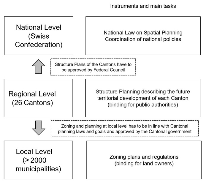
Fig. 1. Simplified overview on the Swiss Spatial Planning System highlighting the central role of the cantonal level
Source: own work (2023).
In accordance with their central role in spatial planning, the cantons are also very active in the area of spatial monitoring. The focus is often placed on the contents of the structure plans or the central spatial topics for the respective canton. The differences between the cantons are also huge here; the Canton of Zurich – as one example – has established a very comprehensive spatial observation, other cantons have much less resources and focus on rather basic activities, while in Eastern Switzerland, there has been established a pragmatic ‘merger’ of various (often smaller) cantons in the area of spatial observation and spatial analysis. It should be mentioned here that 10 years ago an attempt was made, initiated by the scientific community (IRAP, 2013), to harmonise the spatial observations, or more concretely: the indicators of the cantons that were in the foreground for this purpose. Many cantons were directly involved in this project, and the Federal Office for Spatial Development was also part of the project support group. As a result, around 30 central indicators were developed. The subsequent implementation was then left to the cantons, or in other words: the cantons were free to decide whether or not they wanted to rely on this ‘consolidated set’ of indicators, depending on their needs. As far as I know, this harmonisation has not been monitored in terms of its success. It may be assumed that a certain orientation function has been achieved, but certainly not harmonisation throughout.
Let us turn to the level of the municipalities, which again presents a different picture. There are 2,136 municipalities in Switzerland (as of 01 Jan 2023). This number has been steadily decreasing since 1990: 30 years ago, there were still almost 3,000 municipalities. The drivers of the mergers are financial reasons and pressure for efficiency, but also the surge in professionalisation (not least in spatial planning), which in many cases has suggested a merger or even made it necessary. With regards to spatial monitoring, it may be stated that larger municipalities sometimes conduct comprehensive spatial monitoring as part of their planning activities. This will not be discussed further here. What should be emphasised, however, is the Statistics of Swiss Cities published by the Swiss Association of Cities (SSV), which was founded in 1897. The association has 130 members and is based on Article 50 of the Federal Constitution, which obliges the Confederation to take special account of the needs and interests of cities and agglomerations in its policies. From the point of view of spatial observation, these annual statistical volumes provide valuable material regarding the state of the urban space. This becomes evident just by looking at the thematic focus of the last three editions (Schweizerischer Städteverband, 2020, 2021, 2022): Land-Use in the City, Housing in the City, and A Look Beyond the Core City Boundaries. The table and analysis volumes have been published jointly by the SSV and the Federal Statistical Office (FSO) since 2016. This is certainly due to the high proportion of data from FSO, especially since the increased conversion to registers a good 10 years ago, which means that certain key figures are now available annually. The earlier editions were the result of a cooperation between the SSV and Statistics Zurich.
After a policy for urban space was formulated for the first time in 2001, the Federal Office for Spatial Development (ARE) established a special publication series in the 2000s entitled Monitoring urban space in Switzerland. There, the primary aim was to present and analyse the growing urban centres as diverse and interlinked spaces. The aim was to increase the understanding of the functional view of agglomerations – across the ‘mighty’ municipal borders. The monitoring was concluded in 2009 with a synthesis report (Schweizerische Eidgenossenschaft, 2009). At the same time, the federal government had already established a basis for financially supporting urban areas and their projects for the coordination of settlement and transport with the instrument of the so-called agglomeration programmes (Schweizerische Eidgenossenschaft, no date a) – provided that they would fulfil certain requirements. Since then, specifically defined monitoring and controlling indicators have been used within this framework. The more comprehensive, general orientation of the Monitoring urban space in Switzerland was less in demand and thus no longer continued. To some extent, the Statistics of Swiss Cities in its new form since 2016 can be seen as a replacement − although here, of course, the perspective of the participating cities now dominates and not a view against the background of a (then new) federal urban policy as was the case at the time with the Monitoring urban space in Switzerland.
The European Programme City Statistics also examines the level of the cities. Switzerland participates in this framework with 9 cities. A description of the contents and orientation of the programme can be dispensed with here. FSO assumes the role of the patron for this participation – as a link between the involved Swiss cities and the programme – by organising the participation in the programme and processing the data in consultation with the cities. Of particular interest here are the cross-border datasets available for certain indicators for the transnational functional urban areas of Geneva and Basel. From the point of view of spatial observation, the synthesis reports that FSO regularly devotes to certain topics are also of great interest. In these reports, City Statistics indicators are highlighted, primarily for international comparison, of course, but at the same time other national indicators are also used that can bring added value to the investigation of the respective topic. This results in number and fact-based analyses that can be used for the interpretation of spatial trends. One recent example is the publication on Young People in Cities (Schweizerische Eidgenossenschaft, 2021b).
Before concluding with a look at spatial monitoring at the federal level, it is worth considering the topic of sustainability indicators: namely within the framework of the MONET System (Schweizerische Eidgenossenschaft, no date d) and the Cercle Indicateurs indicator system (Schweizerische Eidgenossenschaft, no date b).
MONET (Monitoring Sustainable Development) was established in the 2000s to measure the extent to which Switzerland was on the path to sustainable development. Later, the system was supplemented with indicators that also allowed comparability between developments in Switzerland and global developments. The system was also adapted to the systematics of the SDGs. Although much of the data is also available regionally, such an evaluation is not conducted – the focus is on development throughout Switzerland. The level of the cantons and cities, though, is very well represented, but in a different indicator system: the Cercle Indicateurs. This is – somehow distinctively Swiss – a bottom-up project led jointly by ARE and FSO in which 19 of 26 cantons and 29 cities are currently participating voluntarily. Both the set of cantons and the set of cities include the same 10 themes. Also, both sets consist of 32 indicators. However, the choice of indicators differs in part because certain aspects are more relevant for cities than for the political level of the cantons. The indicators generally have an orientational function and do not allow the measurement and assessment of specific political programmes.
In the area of sustainability indicators, too, it thus becomes clear how strongly the respective level-specific requirements and needs dominate in Switzerland due to its political structure, as well as due to the great heterogeneity of the spatial conditions. It seems neither realistic nor does there seem to be a respective demand to design all-encompassing indicator systems that are accepted and usable across all levels. The definitional sovereignty to decide which indicators are appropriate for the respective level is clearly important for the federal units.
Against this background, I will now focus on spatial observation and, at the same time, to a certain extent to another multi-level system.
On the first ‘level’ there are the authoritative ‘non-political’ data and indicator producers, such as the FSO and swisstopo (Swiss Federal Office for Topography) in particular. A large part of the data that can be used for national spatial observation and also various indicators are collected and made available by FSO. This includes mainly information on land-use and land-cover (Schweizerische Eidgenossenschaft, 2021a), but also on buildings and dwellings (Federal Buildings and Housing Register) or, of course, the basic data on population (STATPOP) and employment (STATENT). In addition, swisstopo provides a lot of mainly georeferenced data (and, by the way, also a stunning collection of historic maps and aerial pictures). This includes data from the official cadastral survey or the Topographic Landscape Model (TLM) (Schweizerische Eidgenossenschaft, no date c). Some of these datasets are rather new, but they can increasingly be used for analysis and intersected with each other or with other data in geographic information systems (GIS), which in some cases allows completely new types of analyses and insights. In addition, they provide support for new possibilities in the field of interpreting aerial and satellite images using machine learning approaches.
At the next ‘level’, sectoral, specialised policy systems (especially environmental policy or regional policy, but transport policy or housing policy could as well be mentioned here) can already obtain and use a large part of their required information from this basic data and indicator supply. In addition, further data from other providers, e.g., analyses of the housing market or special regional economic data and analyses, will add to the picture. In some cases, additional data is also collected specifically. This information is then systematised and focussed within the framework of these specialised policies and processed into tailor-made monitoring and controlling instruments for the respective policies. The thematic focus and the requirements of the various sectoral systems are very specific, and the data needs are correspondingly heterogeneous. But the bottom line is that statistical-analytical information products are created which have the greatest possible utility and informative value for the corresponding policies.
ARE, being responsible for spatial development policy, can also be regarded as such a specialised system. However, spatial development is a cross-cutting task in which most other sectoral policies play a role in one form or another, or where there is by definition a strong thematic interconnection. For its spatial monitoring, ARE, therefore, requires information (data, indicators, analyses) of a large thematic breadth. In this respect, one can in fact speak of a further level here, where the information from the two upper (or ‘upstream’) levels flows together and is synthesised. In addition, of course, there is also a need for further, specifically spatial or spatial development, policy-based knowledge.
Exchange processes between the levels and actors are key. For the spatial monitoring of ARE, it is of outstanding importance that the content-related and political needs can be proposed and discussed in a close exchange with the primary data and indicator producers, and that the providers produce or report the data and indicators in such a way that they can be used as directly as possible for the purposes of spatial monitoring, both in terms of definition and methodology. To this end, there are various information and coordination networks, as well as close cooperation in concrete projects (for example, on register adjustments, new indicators, updates of spatial typologies, etc.).
Having stated that, as mentioned above, ARE is responsible for a cross-sectional policy (see Fig. 2). The data, indicators, and analyses compiled at the level of the related sectoral or sectoral policy observation systems thus provide important information that can be drawn on as needed. As already mentioned above, a certain heterogeneity must be dealt with in terms of spatial level, time series, methodology or definition of indicators. This requires adaptations in some cases. As with the primary providers, a regular, close dialogue is also important here. This dialogue takes place within the framework of networks or on a project-related basis. An example of this is the Swiss Environmental Report (Schweizerische Eidgenossenschaft, 2022b), which is published every three years under the direction of the Federal Office for the Environment (FOEN) and where there are various content-related interlinkages with spatial development policy. There is a need for regular mutual agreement on suitable indicators and their interpretation. Another indicator-based project of FOEN is Landscape Monitoring Switzerland (in German: Landschaftsbeobachtung Schweiz – LABES) (Schweizerische Eidgenossenschaft, 2022a) with a regular publication of new and updated results. Here, too, close coordination and cooperation is key.
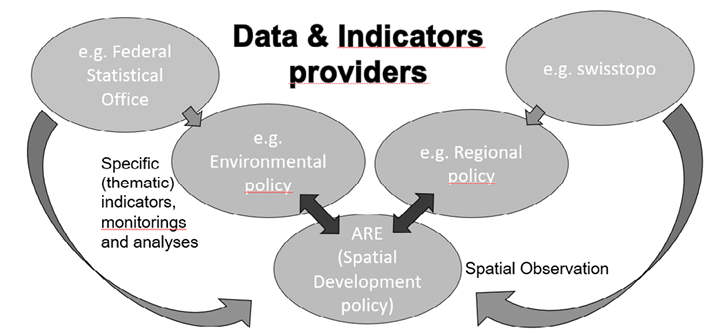
Fig. 2. Multipolar System of Spatial Observation in Switzerland (at the national level)
Source: own work (2023).
This article does not provide an actual and comprehensive description of spatial monitoring as implemented by ARE, as the focus here is on the multi-level and multi-polar aspects. Consequently, the various activities and strategies which of course shape and characterise the spatial observation of the ARE in addition to the described ones, like ‘obtaining’ and transforming the already available spatial observation-relevant information and the described exchange activities and project collaborations, will also not be dealt with.
It must also be made clear that the level of federal data and activities reflected here cannot, of course, be viewed in isolation – exchanges with cantons make a great deal of sense and are also maintained on a case-by-case basis. This exchange, for example with the cantonal spatial observation offices, could certainly be intensified in the future. The view across the national border is another aspect that is not discussed here, but which will also become even more important. It does not only consider the regional level of cross-border agglomerations (e.g., Geneva, Basel, Ticino) but also the link with the wider European territorial development and European spatial observation. The ESPON Programme (ESPON, no date), in which Switzerland has been actively involved since the first phase of the programme, comes to mind here. It is clear that this discussion would open the doors to yet another multi-level system.
In conclusion, it should be noted that Switzerland, with its federal structure, can probably serve as an example that one-size-fits-all solutions do not always make sense. A certain degree of harmonisation is certainly important, and can be achieved by a mix of top-down and bottom-up measures – but should not be overvalued. It does not necessarily need huge indicator systems that are applicable to all users and harmonised across all levels. The approach of allowing the different levels of government, as well as the various sectoral policies the greatest possible freedom in defining and discussing their needs and structuring their indicator, monitoring and controlling systems may be more fruitful in the end. Because many small ‘laboratories’ often generate more suitable and beneficial – and ultimately more accepted – solutions. The decisive factor here is, as shown above, the continuous exchange and communication process. The daily work, so to speak, which provides the necessary ‘cement’ in this multi-polar system and also ensures its dynamic further development in terms of content.
ESPON (no date), Inspire Policy Making with Territorial Evidence, https://www.espon.eu [accessed on: 17.02.2023].
IRAP – INSTITUT FÜR RAUMENTWICKLUNG (2013), Harmonisierung der kantonalen Raumbeobachtungen, https://www.gps-concorso.ch/index.php?id=13033&content=47727&id_project=830 [accessed on: 17.02.2023].
SCHWEIZERISCHE EIDGENOSSENSCHAFT, ARE – BUNDEAMT FÜR RAUMENTWICKLUNG (no date a), Programm Agglomerationsverkehr, https://www.are.admin.ch/are/de/home/mobilitaet/programme-und-projekte/pav.html [accessed on: 17.02.2023].
SCHWEIZERISCHE EIDGENOSSENSCHAFT, ARE – BUNDEAMT FÜR RAUMENTWICKLUNG (no date b), Cercle Indicateurs: Nachhaltigkeitsindikatoren für Kantone und Städte, https://www.are.admin.ch/are/de/home/nachhaltige-entwicklung/evaluation-und-daten/nachhaltigkeitsindikatoren/cercle-indicateurs.html [accessed on: 17.02.2023].
SCHWEIZERISCHE EIDGENOSSENSCHAFT, ARE – BUNDEAMT FÜR RAUMENTWICKLUNG (2009), Monitoring urbaner Raum Schweiz – Städte und Agglomerationen, https://www.are.admin.ch/are/de/home/medien-und-publikationen/publikationen/staedte-und-agglomerationen/monitoring-urbaner-raum-schweiz-stadte-und-agglomerationen.html [accessed on: 17.02.2023].
SCHWEIZERISCHE EIDGENOSSENSCHAFT, ARE – BUNDEAMT FÜR RAUMENTWICKLUNG (2012), Raumordnungskonzept Schweiz, https://www.are.admin.ch/are/de/home/medien-und-publikationen/publikationen/strategie-und-planung/raumkonzept-schweiz.html [accessed on: 17.02.2023].
SCHWEIZERISCHE EIDGENOSSENSCHAFT, BUNDESAMT FÜR STATISTIK (2021a), Bodennutzung, -bedeckung, https://www.bfs.admin.ch/bfs/de/home/statistiken/raum-umwelt/bodennutzung-bedeckung.html [accessed on: 17.02.2023].
SCHWEIZERISCHE EIDGENOSSENSCHAFT, BAFU – BUNDESAMT FÜR UMWELT (2022a), Landschaftsbeobachtung Schweiz (LABES), https://www.bafu.admin.ch/bafu/de/home/themen/landschaft/zustand/-landschaftsbeobachtung-schweiz---labes-.html [accessed on: 17.02.2023].
SCHWEIZERISCHE EIDGENOSSENSCHAFT, FOEN – FEDERAL OFFICE FOR THE ENVIRONMENT (2022b), Environmental report 2022, https://www.bafu.admin.ch/bafu/en/home/documentation/reports/environmental-report.html [accessed on: 17.02.2023].
SCHWEIZERISCHE EIDGENOSSENSCHAFT, FEDERAL OFFICE FOR TOPOGRAPHY SWISSTOPO (no date c), The Topographic Landscape Model TLM, https://www.swisstopo.admin.ch/en/knowledge-facts/topographic-landscape-model.html [accessed on: 17.02.2023].
SCHWEIZERISCHE EIDGENOSSENSCHAFT, FEDERAL STATISTICAL OFFICE (no date d), The MONET 2030 indicator system, https://www.bfs.admin.ch/bfs/en/home/statistics/sustainable-development/monet-2030.html [accessed on: 17.02.2023].
SCHWEIZERISCHE EIDGENOSSENSCHAFT, FEDERAL STATISTICAL OFFICE (2021b), City Statistics: Junge Menschen in den Städten, https://www.bfs.admin.ch/bfs/en/home/statistics/catalogues-databases.assetdetail.18644278.html [accessed on: 17.02.2023].
SCHWEIZERISCHE EIDGENOSSENSCHAFT, FEDLEX – THE PUBLICATION PLATFORM FOR FEDERAL LAW (2019), Federal Act on Spatial Planning – SPA, https://www.fedlex.admin.ch/eli/cc/1979/1573_1573_1573/en [accessed on: 17.02.2023].
SCHWEIZERISCHER STÄDTEVERBAND (2020), Statistik der Schweizer Städte 2020: Ein Blick über die Kernstadtgrenzen hinaus, https://staedteverband.ch/de/Detail/statistik-der-schweizer-stadte-2020-ein-blick-uber-die-kernstadtgrenzen-hinaus?share=1 [accessed on: 17.02.2023].
SCHWEIZERISCHER STÄDTEVERBAND (2021), Statistik der Schweizer Städte 2021: Wohnen in der Stadt, https://staedteverband.ch/de/Detail/statistik-der-schweizer-stadte-2021-wohnen-in-der-stadt?share=1 [accessed on: 17.02.2023].
SCHWEIZERISCHER STÄDTEVERBAND (2022), Statistik der Schweizer Städte 2022: Bodennutzung in der Stadt, https://staedteverband.ch/de/Detail/statistik-der-schweizer-stadte-2022-bodennutzung-in-der-stadt?share=1 [accessed on: 17.02.2023].