Volume 30, 2023, Number 2
https://doi.org/10.18778/1231-1952.30.2.06


Abstract. The debate about exurbanites and exurbs has ever been an Anglo-American phenomenon. Due to the limitless space for growth and the individual preferences of living in single-family homes, the exurban census tracts were the fastest growing urban type in the USA for several decades. The increase in highway infrastructure lead to an auto-centric development of land and an ongoing urban sprawl in search for natural amenities and affordable housing. This was not the case in Europe for a long time as Europeans preferred to live closer to the place of work and the historically grown structures of the urban development. However, after the COVID-19 pandemic and the restructuring of a new office culture with remote work as the new condition and growing preferences for more living space and green amenities, exurbs could also evolve in the European context. In this investigation, the authors try to identify exurbs in the German context based on a multi-criteria analysis. We find that they are mostly located in the east and north of Germany around Hamburg and Berlin, and to a minor extent to the west and south of Germany. While there has not been a significant increase of exurbs in the past years, the question remains whether the COVID-19 pandemic has influenced the exurbanisation and the related issues to a sustainable urban development according to SDG 11. Further research on the characteristics of exurbs is needed to provide additional policy recommendations and monitor the development of potential exurbs in the future.
Key words: exurb, urban development, regional development, residential location, commuting.
In the current discussion on re- and suburbanisation (Schmitz-Veltin, 2015), as well as within recent urban development models for European cities (van den Berg et al., 1982; Kabisch and Haase, 2011), one type of city outside the Anglo-American region rarely if ever appears: exurbs. The term ‘exurbanities’ was coined in the 1950s by A. C. Spectorsky (1958). It initially referred to metropolitan or suburban residents with a certain voluntarily chosen way of life in the countryside, but with an economic basis of work in the metropolis. Exurbs are essentially rural in character and are located outside the comfortable commuting distances to core cities and the area characterised by continuous suburbanisation. They are nevertheless a functional part of a region related to the core (Lamb, 1983). Due to the current development caused by the COVID-19 pandemic and the emergence of the so-called “zoom towns” in the USA, which are now used by formerly urban population strata for living and working and are characterised by high natural attractiveness and lower rents in the surrounding areas of the metropolises (Florida and Ozimek, 2021), the question arises whether this type of settlement could also have a certain significance in Germany in the future.
Initial results from an empirical approach based on a multi-criteria analysis suggest that the exurb urban type is not yet widespread, depending on the indicators and the choice of thresholds. However, it is not foreseeable how the mix of increasingly widespread remote work, still rising real estate and rental prices in and in the immediate vicinity of metropolitan areas, and the associated increase in commuting times will affect the development of exurbs in Germany. Initial surveys suggest a shift in residential preferences toward small and medium-sized towns (SMST) (Neumann et al., 2022). The first theses are raised in this article in the discussion of results, and further recommendations for policymakers in dealing with the unknown city type of the exurb are formulated. First, however, a definition of the term and a discussion of the literature on the exurb debate will be presented.
The exurb debate is about both exurbs as places and exurbanites as residents with specific lifestyle preferences (Nelson, 1992). Even though they are outside of comfortable commuting distances, a significant proportion of their residents still commute to the core cities for work. These residents accept the long commuting distances because it allows them to combine high-quality jobs and urban infrastructure opportunities with a lifestyle fundamentally shaped by rural qualities. The exurban space is, therefore, changing from a space of agriculture to a projection space of certain lifestyles (Goddard, 2009). The exurban lifestyle is anti-urban, but it is also anti-suburban (Taylor, 2011).
The outer boundaries of exurbia are determined by commuting distances, while the inner boundaries are determined by the rural character and natural area qualities that the space still retains despite its settlement growth. The typical settlement pattern of U.S. exurbs is isolated single-family development or strip development oriented along major roads, which is contrary to the goal of SDG 11 to promote resource-efficient transport systems (UN, 2023). In the U.S., the phenomenon of exurbs had relevance in that, according to official calculations and definitions of exurbs in official statistics, 59 million residents, or about 25% of the total population, lived in exurbs in 1985 (Nelson, 1992, p. 362). However, different definitions of the exurb phenomena lead to rather smaller population numbers in this city type starting at around 10 million people living in exurbs in the USA (Golding and Winkler, 2020). Between the 1980s and the early 2000s, the U.S. was diagnosed with largely continuous increases in migration rates to exurban areas: core cities and suburban areas lost a net 0.5% of their residents annually to exurban areas, which is consistently a remarkable figure when accumulated over long periods (Osgood, 2011). Against this backdrop, exurbs were even discussed at times as the most important form of living in the U.S. in the future. At the very least, the developmental dynamics of this space justified distinguishing it as a separate category even from suburbia (Nelson, 1992).
Although the debate about exurbs shares some similarities with the debate about multi-local living arrangements, there are also some key differences between the two concepts. While multi-locality highlights the importance of balancing different locations and embracing diverse commuting patterns and multiple places of residence (as discussed in Danielzyk et al., 2020), the exurb debate focuses on the appeal of rural living and assumes traditional urban-rural commuting patterns between home and work.
The term exurb refers in its origin to the situation in the U.S. In parts of the data-based city-region research in the U.S., the term has become a fixed category of ring-zonal models. Exurbs can also be seen as an umbrella term for all developments outside the cores of cities, i.e., both core-based suburbanisation and developments in rural places far from cities (Larsen et al., 2017). Closer to the basic idea of the term, however, is its use for the type of place further from the centres and also beyond the sub-urban zone, which still has significant linkages to metropolitan areas but is still predominantly rural (Crump, 2003). Carrutthers and Vias (2005) consequently define four spatial types: Urban, Suburban, Exurban, and Rural. Exurbs are thus classified here in terms of their location to the core and their density between suburbs and rural communities (Robinson et al., 2005). In the official statistics of the U.S., the counties were assigned to one of these types according to the area, which made it possible to roughly determine the quantities of exurbs: this results in the above-mentioned, longstanding and relatively high figure of one quarter of the population in the U.S. living in exurbs. Despite this zonal classification, however, researchers have repeatedly raised the question of whether suburbia and exurbia can be analysed separately at all (Nelson, 1992). In some cases, no distinction has been made between suburban and exurban sprawl (Audirac et al., 1990, p. 475), partly because the transition from suburban to exurban space has been regarded as fluid (Lucy and Phillips, 1997, p. 267). It should be mentioned in addition that even in the U.S. by far not all zonal models explicitly adhere to the concept of exurbs. Antrop (2000), for example, distinguishes in his model: urban core, inner fringe, outer fringe, rural commuting zone, and deep countryside.
For the European debate, the concept of exurbs played, if at all, a much smaller role than for the U.S. This is partly because, compared to the U.S., European urban regions are more concentrated in the cores. Their outer boundaries expand less rapidly and, therefore, the phenomenon of exurbia is probably less pronounced, which could also be due to higher transportation costs (Hesse and Siedentop, 2018). Despite that, this circumstance could also be explained by the fact that in European urban region research, the term ‘periurban’ is often used instead of ‘suburban,’ and no distinction is made between more central suburban and more decentralised spaces. Much of what is referred to as periurban communities in France, for example, is located on the outer fringes of densely populated areas and would be classified as exurb in the United States (Charmes, 2009). Anyway: exurbs stand in contrast to the European concepts of polycentric urban regions (Growe et al., 2012) and planning goals like decentralised concentration. Their low density and large distances to city centres hinder efficient public transport systems.
Compared to the 1980s and 90s, the term exurb also seems to have lost some meaning in the U.S. in recent years. It does not play a role in current urban-regional research, much of which is centred around the term “postsuburbia” and shaped by the intercontinental convergence of views (Phelps, 2015, 2017a; Wu and Keil, 2020; Wu and Phelps, 2011). On the one hand, this may be due to the fact that the trends of suburbanisation or even counterurbanisation in many European countries, but also in the U.S., have been eclipsed, if not replaced, by the unmistakable trend of metropolitan reurbanisation in recent years (Dembski et al., 2017; Brombach et al., 2017). In particular, qualitatively oriented post-suburbanisation research is levelling the contrast between urban cores and suburban space (Keil and Addie, 2016) and is overall more focused on the areas of urban regions closer to the metropolis (Keil and Shields, 2016) rather than their periphery. Furthermore, it does not distinguish – at least not consistently systematically – more central and wider surrounding areas (Keil, 2018). In some ways, exurb research thus even stands in contrast to the now highly differentiated research on new urban nodes in peri-urban spaces. After all, the exurbs are characterised by the fact that they are more strongly connected to the metropolises through their commuting relationships than their distances would suggest, while the new nodes are characterised by their relative independence from the metropolises and are sometimes even seen as anchored in the global economy independently of them (Phelps, 2017a).
Exurbs, as shown above, are partly equated with the zone of the same name in U.S. studies based on official data, i.e., all municipalities located in this zone are referred to as exurbs. This also explains the high number of inhabitants of the exurbs determined by the means of this classification: already in the 1980s, a quarter of the U.S. population lived in exurbs (Nelson, 1992; Davis et al., 1994; Nelson and Dueker, 1990). A central weakness of the general assignment of all places located in the exurban zone to the category of exurbs is, however, that not only the small places but also the relatively autonomous centres in this spatial category are designated as exurbs, even if they are not oriented toward the metropolises at all. Also, centres in rural areas are called exurbs, even though they no longer have a rural character in their settlement structure. Conversely, it is also debatable whether exurbs are really a place type in their own right or whether exurbanites are not seeking exurban niches in suburban municipalities that are relatively central in the ring-zonal model but still retain their rural character (Crump, 2016). What becomes clear is this: assignment to a zone alone is not sufficient to classify a municipality as exurb. First, the location in space, second, the intensity of interdependence with the nearest metropolis, and third, the density of the place are decisive.
Thresholds for exurbs used in empirical studies are based on the U.S. situation and vary considerably between studies (for a detailed overview, see Berube et al., 2006, p. 4): on the question of the spatial delineation of metropolitan regions in which exurbs are to be located, U.S. studies vary between 50 and 70 miles (e.g., Shrestha et al., 2012; Lamb, 1983). In terms of metropolitan linkages, for Nelson (1992), exurbs are characterised by more than 10% of employees commuting to the nearest metropolitan area. However, other authors set the threshold value much higher (up to 30%) which shows the inconsistency of the exurb definition (Wolman et al., 2005). As far as the building densities to be applied are concerned, the studies for the U.S. vary considerably. Clark et al. (2009) define low-density development of exurbs as a density of 40–400 residents per square mile. Nelson and Sanchez (1999) even set the upper limit at 999 residents per square mile. Again, Theobald (2005) suggested other thresholds: exurban areas have densities of 0.69-16.18 ha per dwelling unit, thus lying between urban and rural densities, while Robinson et al. (2005) assumed a plot size of 0.2-20 ha for exurban communes.
The most well-founded study of exurbs in the U.S. to date, insofar as it contains the most convincing operationalisation of exurbs, was presented by Berube et al. (2006). They schematically illustrate the situation in the space of exurbs. According to this, exurbs are characterised by the following features:
According to this definition, 10.8 million residents, or 4 % of the total population and 6% of the residents of metropolitan areas in the U.S., lived in exurbs in 2000. They accounted for about 3% of U.S. census tracts and were less present than studies from the 1990s indicated. However, their growth was very strong: the population of exurbs increased by 30% between 1990 and 2000, twice that of the metropolitan areas as a whole. Also interesting are the findings on regional differences, some of which are contrary to studies of development in the 1970s (Lamb, 1983). The South and Midwest are thus more exurbanised overall than the Northeast and West, where the regions from which early exurbanisation research often drew its examples are located (such as New York / Niagara County or the Rocky Mountains; see Spectorsky, 1958; Goddard, 2009; Carruthers and Vias, 2005).
Typologies of exurbs have been only tentatively developed, nor have they been pursued: Hayden (2003) distinguished three types of exurbs: ‘reluctant suburbs’ that resist growth, ‘hot towns’ that are attractive for telecommuting, and ‘residential wallhallas’ in particularly high-value landscapes. Berube et al. (2006) differentiated low cost exurbs from those with particularly high quality housing and those with particular recreational value.
Finally, however, it must be indicated that the threshold values for the determination of exurbs are arbitrary in some respects and, apart from the wide range of values, refer almost exclusively to the situation in the U.S. Similarly, data availability plays a major role in the selection of indicators in the U.S. (Ottensman, 2017). Here, this study attempts to establish an adaptable, exploratory approach for the case study of Germany, which is equally transferable to other countries in Europe.
From the beginning, the debate about exurbs has been explosive because the term exurbanite was used to refer to a certain group of inhabitants that, due to its increasing importance, could also have a decisive influence on elections (Berube et al., 2006). Originally, the exurban lifestyle was considered a privilege of population groups with the highest social status; however, in the course of mass motorisation, it became possible for upper-middle-class groups as well.
U.S. statistics provide more precise information on the socio-structural characteristics of exurban communities. However, it is important to note, on the one hand, the broad definition of exurbs in the statistics, which refer to entire zones, and, on the other, the fact that exurban communities have disproportionately high shares of commuters. However, exurbanities are also a minority in these communities. An analysis of socioeconomic data from the 1990s U.S. Census showed that compared to the U.S. average, exurb residents tended to be white, middle-class, they lived in childless households, and commuted more. While in the U.S. the percentage of whites in core cities was less than 50%, in the exurbs it was 95%. In the 2000 and 2004 presidential elections, 58% and 62% of exurb residents voted for the Republican candidate Bush, respectively, which was clearly the highest proportion in any spatial category (Lang and Sanchez, 2006). However, it also became clear in the studies based on U.S. statistics that the similarities between exurban and suburban households were greater overall than the differences (Nelson and Sanchez, 1999). Regional primary surveys, however, certainly uncovered greater differences between suburbanites and exurbanites: a study of the commuting behaviour of exurbanites in the Portland region (Davis, 1993; Davis et al., 1994) showed that compared to the residents of sub-urban communities, exurbanites accepted longer commute times in exchange for more space with lower housing costs, a rural setting, and also better schools. In addition, significant differences were found between exurbanites in small towns and those in villages, but these were likely explained by region-specific factors. Again, the results of the study by Berube et al. (2006, p. 1) are particularly illustrative, as the type of exurbs is clearly specified here; it clarifies some preconceptions about exurbs:
“Residents of the ‘average’ exurb are disproportionately white, middle-income, homeowners, and commuters. Yet exurbanites do not conform to all popular stereotypes. For instance, they do not appear to telecommute, work in the real estate industry, or inhabit super-sized homes at higher rates than residents of other metropolitan county types. Middle-income families’ ‘drive to qualify’ for more affordable new homes that are in limited supply elsewhere fuels growth in many metropolitan exurbs.”
In much of the earlier exurb research, their spatial consequences were viewed as problematic. In some assessments, a certain scepticism towards the self-interested exurbanites is not infrequently evident, at least subliminally: exurbanites maintain a primarily rural lifestyle, but also take advantage of the benefits of the big city (Nelson, 1992). They enliven the economic life of metropolises, but claim a large share of the resources in rural areas. For Lamb (1983), the exurbs are more expensive and energy consuming than more compact forms; they cost agricultural land and are fiscally problematic (Berube et al., 2006). It causes transportation problems and does not create stable neighbourhoods; in some cases, it even leads to conflicts between old and new residents. These conflicts are mainly related to land-use, the change of which is associated with the loss of importance of agriculture (Smith and Sharp, 2005) and forestry (Egan and Luloff, 2000). Environmental impacts associated with exurbanisation have also been viewed sceptically (Larsen et al., 2017). Studies showed that land-use change associated with the increase in exurban residential forms (Theobald, 2004) was accompanied by a reduction in the biodiversity of regions (Hansen et al., 2005). There is criticism of new, larger settlement units that have been built in a nevertheless rural environment at great speed without integration into existing structures.
However, in contrast to the sceptical assessment of changes in rural social structures, especially in exurbanisation research in the 1980s, views have increasingly emerged in recent years that accepted this phenomenon rather as part of the transformation of cultural landscapes, viewed it in a more differentiated way, and tried to deal with it constructively. Larsen et al. (2017) analysed for a former agricultural valley in Colorado how new networks between old and new inhabitants emerged in these spaces, in which common perceptions of the space played an important role, especially with regard to natural disasters and aspects of environmental protection. With growing numbers of people working remotely, time spent in the exurbs could increase and lead to improved integration of new inhabitants in the formally rural villages and towns. For the structural conflicts between newcomers and existing residents (Crump, 2003, p. 190), methodological tools for conflicts of use were developed (Caruso et al., 2007). Negative assessments of expansive exurban settlement forms are based on GIS analyses (Clark et al., 2009) and analyses of exurban settlement types and building forms, for example, in relation to their carbon footprints (Visscher et al., 2014; Nassauer et al., 2014). Increasing costs for building and maintaining infrastructure are still the biggest problem with the ongoing expansion of exurbs and should be observed closely in the future.
It has been shown that the U.S. reference values cannot be considered for the identification of exurbs. These values vary, on the one hand, due to the available land mass and settlement density, and, on the other, due to different planning systems used. Thus, new thresholds based on the American values must be used to identify potential exurbs.
The first reference here are the metropolitan and urban regions, to which a large part of the commuting movements must lead. To ensure comparability of urban regions at the European level, the Functional Urban Areas (FUA) from Eurostat (2018), which are delineated at the municipal level (Link, 2021), are suitable. These are characterised by the following features (Eurostat, 2018):
The FUAs serve to delineate the exurbs from the suburban catchment areas of the core city and also to identify the exurbs’ own commute to the nearby FUA.
In addition to the FUAs, the census-adjusted population of the association municipality in the current 2019 data year is used to delineate the exurbs (Laufende Raumbeobachtung des BBSR, 2022). We use the association municipality level to have a uniform municipality definition in the study and to be able to verify comparative analyses. These association municipalities must be between 2,500 and 50,000 inhabitants in order to calculate commuting movements from community associations not located in the FUAs to the FUAs. Here, not only movements to the core city of the FUA count as relevant commuting movements, but to the entire FUA, since previous studies on the commuting behaviour of exurbanites considered both urban and suburban areas as destinations (Davis et al., 1994). Three reference values are used to incrementally approximate an exurb delineation for Germany: >10% and <15% (low restriction), ≥15% and < 20% (medium restriction), and ≥20 % (high restriction) of commutes into the FUA. In addition, highway accessibility plays a critical role in delineating exurbs in the United States. In the context of identifying the exurbs in Germany, the component of local and long-distance public transport is added, which in this case is accounted for by long-distance transport and the large distances it can bridge in a short period. Depending on the degree of restriction, the proximity is set at <30 and ≥20 (low restriction), <20 and ≥10 (medium restriction), and <10 (high restriction) minutes of driving time. Important indicators continue to provide the endowment of community associations with single-family homes, which makes the communities interesting for potential exurbanites. For this purpose, we calculate the share of residential buildings with one dwelling in all residential and non-residential buildings, the share of residential buildings with one dwelling in all residential buildings, and also the living space per residential building. In this way, we can ensure that the dominant building type is the single-family house, and conversely, we can ensure via floor space that there is little multi-storey construction in the municipal associations. For this purpose, deciles rather than percentages were used, following the classification of Berube et al. (2006). Here, for the percentage of residential buildings with one dwelling in all residential and non-residential buildings and the percentage of residential buildings with one dwelling in all residential buildings, all values ≥ the 5th decile represent low restriction, values ≥ the 7th decile represent medium restriction, and values ≥ the 9th decile represent high restriction. The living space per residential building would have to be low analogous to the high proportion of single-family houses, thus the low restrictions there are ≤ the 5th decile, medium restrictions ≤ the 3rd decile, and high restrictions ≤ the 1st decile. In addition, there is the settlement and transport area per inhabitant, which must be high due to the low population density and the good accessibility of the potential exurbs. Thus, for this indicator, values ≥ the 5th decile represent the low restriction, values ≥ the 7th decile represent the medium restriction, and values ≥ the 9th decile represent the strong restriction. Table 1 provides an overview of the indicators and sources.
| Indicator | Target value (low/ medium/ strong) | Sources |
|---|---|---|
| Location of place of residence outside FUAs, location of place of work in FUAs | Generally valid | Eurostat (2018); Laufende Raumbeobachtung des BBSR (2022) |
| Percentage of commuters in FUAs | 10%/ 15%/ 20% | Eurostat (2018); Laufende Raumbeobachtung des BBSR (2022) |
| Population of place of residence | 2,500–50,000 inhabitants | Laufende Raumbeobachtung des BBSR (2022) |
| Accessibility of highways or IC/EC/ICE stations | 30 minutes/ 20 minutes/ 10 minutes | Laufende Raumbeobachtung des BBSR (2022) |
| Proportion of residential buildings with one dwelling unit out of all residential and non-residential buildings | ≥5th decile/ ≥ 7th decile/ ≥ 9th decile | Laufende Raumbeobachtung des BBSR (2022); |
| Share of residential buildings with one dwelling in all residential buildings | ≥5th decile/ ≥ 7th decile/ ≥ 9th decile | Laufende Raumbeobachtung des BBSR (2022); |
| Proportion of settlement and traffic area per inhabitant | ≥5th decile/ ≥ 7th decile/ ≥ 9th decile | Laufende Raumbeobachtung des BBSR (2022); |
| Living space per residential building | ≤5th decile/ ≤ 3rd decile/ ≤ 1st decile | Laufende Raumbeobachtung des BBSR (2022) |
Source: own work.
The set of indicators used makes it possible to identify potential exurbs in Germany and to determine initial characteristics. First of all, the localisation of exurbs is the first step towards understanding which municipalities in Germany exhibit exurban characteristics at all. Here, the map in Fig. 1 shows the municipalities with strong restrictions in red, medium restrictions in blue, and low restrictions in green. FUAs are highlighted in translucent pink, with highways as solid lines and rail lines as dashed lines. In addition, to monitor the development of potential exurbs, the exurbs from 2008 and to the most current period of 2019 are shown in comparison. It should be noted that all housing-related data for 2008 is from the 2011 Census and, therefore, only partially reflects 2008 conditions.
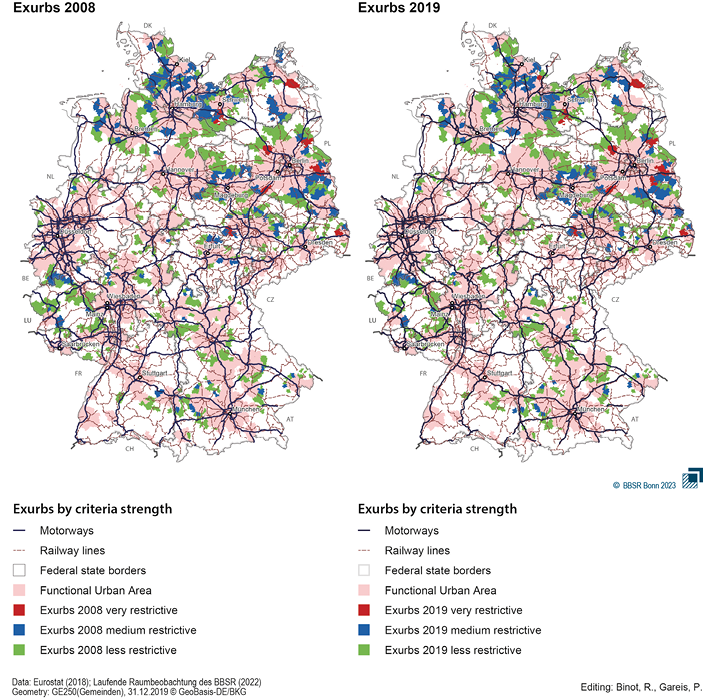
Fig. 1. Exurbs in Germany
Source: Laufende Raumbeobachtung des BBSR (2022).
The map shows that exurbs with strong restrictions are only located in the Berlin area, south of Greifswald, Schwerin and in 2019 also Kiel, as well as near Bautzen and Leipzig. This strong concentration in eastern Germany testifies to a settlement structure that is less polycentric, resulting in a more concentrated commuting pattern. In addition, the population density in rural eastern German areas are often lower than in western German municipalities, and thus the settlement and transport area per inhabitant is much more pronounced. Despite all this, it must be noted that the strict restrictions result in only eight (2008) or ten (2019) municipalities that meet the criteria of an exurb. If the restrictions were relaxed to a medium level, significantly more municipalities would have already shown the potential to be an exurb. 126 (2008) and 119 (2019) exurbs were identified using these criteria. In this case exurbs are strongly concentrated in the Berlin and Leipzig hinterland, as well as the areas between Hamburg and Schwerin, and Kiel. In addition, there are some clusters in the Eifel region, as well as between Hanover and Magdeburg, and near Erfurt. Generally, there is a clear concentration in the north and east of the country. At the lowest level of restriction, southern German municipalities are increasingly being considered as exurbs. Likewise, the gaps to the FUAs are filled with potential exurbs on a larger scale, so that many municipalities no longer have a direct border to the FUAs and are sometimes very solitary, such as in Mecklenburg-Western Pomerania, Lower Saxony, and Rhineland-Palatinate. In total, 474 (2008) and 461 (2019) potential exurbs could be found there. It is noticeable that exurbs are strongly represented in the Polish and Luxembourgian border regions, but less so in other border regions of Germany.
The localisation of exurbs provides a first overview of a community type that has been affected by severe shrinkage in the past two decades, but which may be a potential winner after the pandemic and the accompanying changes in residential preferences and new work realities. Population trends, compared to all small and medium-sized towns (SMST) in the 2,500−50,000 population range, were significantly more negative as shown in Fig. 2. While the comparison cities tended to grow over the period from 1994 (index value = 100) even through 2019 and survived the wave of urbanisation since 2000 relatively unscathed, by comparison the exurbs with strong criteria lost over 10% of their populations. The exurbs identified with medium restrictions in 2019 had a population loss of just under 5%, whereas the exurbs with medium restrictions only lost just over 2% in 2008. The exurbs with low criteria are in between in their population development. What is striking, however, is the strong plateauing since 2016, which represents a weakening of the previous urbanisation wave. The remaining question is whether this development will evolve into population growth from 2019 onwards or whether the plateau or previous downward trend will be maintained. In favour of growth is the fact that remote work will remain even after the pandemic and this can already be demonstrated in European office real estate markets (Bergeaud, 2023). This will not only lead to a change in the cities themselves, since purchasing power will flow out of the cities (Court and Borak, 2023) and public transport will be utilised less (Olayode et al., 2022), but will probably also result in a change in the demand for housing.
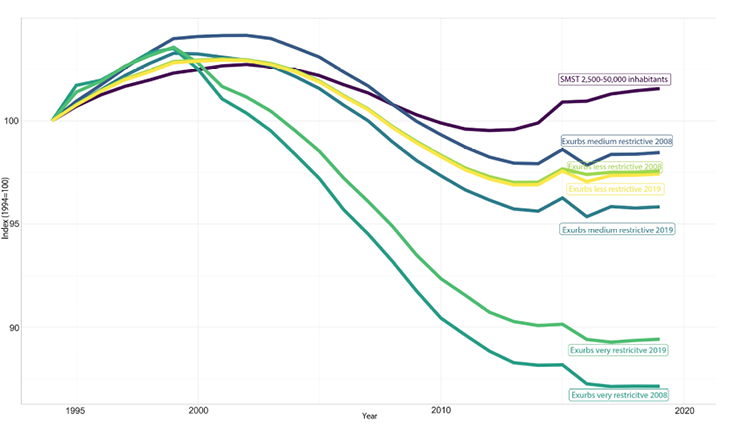
Fig. 2. Population development in Exurbs 1994–2019
Source: Eurostat (2018); Laufende Raumbeobachtung des BBSR (2022).
For example, it has been proven for many years that for families with children, who are the driving factor behind the growth of exurbs in the U.S., the single-family house is still strongly preferred as a form of home ownership, despite all the sustainability efforts. For families with three children, the acquisition rate of single-family homes compared to all other housing types in Germany is 99%, and for four-person households it is still 93% (Amman and Müther, 2022). In addition, real estate prices have risen sharply, coupled with an enormously tight interest rate situation. This combination, which in particular makes homeownership in the city and its suburban communities almost unaffordable, can be another driver for a residential location decision far outside the core cities. Here, it is already evident that the demand for existing properties is gaining in importance compared to new construction (Amman and Müther, 2022), which may lead to increased demand, particularly in well-connected exurbs. Especially single-family homes from the 1970s and 80s might become very popular in the near future when no sufficient construction of homes will be authorised or affordable. Privacy and affordability have always been the main reasons for moving to exurbs (Johnson, 2013). The trend towards exurbs, driven by the aftermath of the pandemic and changing work and commuting patterns, may become more prevalent in Europe in the future.
A debate on the existence of exurbs in Europe has not been opened yet in European research for many reasons. The distances of commuting, the relatively rigid planning laws due to the lack of land and the historically developed cities, and settlement structures differ significantly from the situation in the U.S. Despite all this, there are initial tendencies that the so-called exurbs could also be found in Europe. Although the spatial scales in the U.S. are larger than in Europe, the term ‘exurbs’ so far seems to be appropriate for an international discussion, instead of searching for another term for the European or German context.
The classification approach presented in this paper shows for the first time for Germany where exurban communities could be localised considering three different criterion strengths and two different time points. The increased occurrence in eastern and northern Germany indicates a relatively high potential in these areas to be considered as residential locations for people with exurban residential location preferences. Especially the concentration of exurbs with very restrictive thresholds for the indicators around the monocentric region of Berlin is striking. Furthermore, the lack of exurban communities in the polycentric metropolitan regions of Rhine-Ruhr, Rhine-Main, and Rhine-Neckar shows that they might be too densely populated to attract exurbanites.
When discussing sustainable development, it is crucial to emphasize that exurbs are not aligned with the principles of sustainable spatial development, as defined by the United Nations’ Sustainable Development Goals (2023). The extensive surface sealing caused by single-family homes and the accompanying road infrastructure, which characterizes exurbanisation, directly contradicts the objectives of SDG 11: sustainable transport and sustainable cities and human settlements. In contrast, polycentric structures with decentralised concentrations (Growe et al., 2012), located closer to city centres, appear to be a more favourable settlement forms for sustainable development. Exurbs, with their significant distances from core cities and limited population size, hinder the establishment of efficient public transport infrastructure necessary for sustainable urban living. Thus the question of the role of spatial planning emerges.
The extent and form of exurbanisation in the future will also be influenced by how restrictive regional and local urban containment policies are (Osgood, 2011). Exurbs can be a result of regional planning that limits residential development in suburban areas, which encourages leap frogging, and the spillover of residential development into adjacent more peripheral areas. In addition, community associations identified as exurban have experienced significant population declines over the past two decades and in many cases are likely to have relatively high vacancy rates. Since existing properties in the form of single-family homes are being acquired in particular, due to the current situation on the real estate market, precisely the community associations identified here could experience population growth again in the near future (Amman and Müther, 2022).
The phenomenon of exurbs is likely to continue to change significantly with the digitalisation of work. Exurbanites have so far accepted longer commuting times and are often employed in traditional office jobs, which have a high potential for remote work. Therefore, the thesis that the option of remote work opens up the possibility moving outside comfortable commuting distances than ever before might become reality in the near future. Even if the place of work may still be formally located in the FUA in the statistics, this could lead to a stronger counter-urbanisation from exurbs, which would be accompanied by the creation of new infrastructure and all of its problematic consequences for the society.
Exurbs are still strongly defined by commuting behaviour. Trips between work and home, however, are losing importance in the travel budget compared to leisure-oriented trips. Exurbs are often located outside of regionally planned areas. Long commutes are made not only to work but also for leisure (Taylor, 2011). It would be worth discussing whether, for example, exurbs in the future will also combine living and (digital) working in a rural location that is associated with intensive use of leisure facilities in metropolitan areas or if the connection to the metropolises will loosen due to less frequent travels to work.
Another aspect is how social life in the community associations identified as exurbs will develop in the future. Related to the debates on multi-local lifestyles, since even infrequent commutes involve traveling long distances and thus taking up time that might be lacking for important local volunteer work, exurbanities could change the cohabitation of the identified municipalities. This effect, already identified by Scaff (1952), has also been confirmed in recent studies and requires further investigation in the identified exurbs (Rüger et al., 2022), especially after the COVID-19 pandemic and the increasing facilities for remote work.
Lastly, it is essential to emphasize the importance of future data collection to monitor potential exurban developments. Firstly, comprehensive data should be gathered regarding the construction and age of single-family homes within potential exurban communities. Additionally, conducting interviews with individuals who choose to move to exurbs is crucial in order to gain deeper insights into their motivations. By understanding why people opt for exurban living and exploring the role of spatial planning, we can develop more sustainable options for where and how individuals can lead fulfilling lives. This data collection and analysis will aid in informing future strategies and decision-making processes aimed at promoting sustainable living choices.
AMMANN, I. and MÜTHER, A. M. (2022), ‘Wohneigentumsbildung und Wohnflächenverbrauch – Bestandsaufnahme und zukünftige Entwicklung’, BBSR Analysen Kompakt, 14.
ANTROP, M. (2000), ‘Changing patterns in the urbanized countryside of Western Europe’, Landscape Ecology, 15, pp. 257–270.
AUDIRAC, I., SHERMYEN, A. H. and SMITH, M. T. (1990), ‘Ideal urban form and visions of the good life Florida’s growth management dilemma’, Journal of the American Planning Association, 56 (4), pp. 470−482.
VAN DEN BERG, L., KLAASSEN, L. H., DREWETT, R., ROSSI, A. and VIJVERBERT, C. H. (1982), Urban Europe: A study of growth and decline, Pergamon.
BERGEAUD, A., EYMEOUD, J. B., GARCIA, T. and HENRICOT, D. (2023), ‘Working from home and corporate real estate’, Regional Science and Urban Economics, 103878.
BERUBE, A., SINGER, A., WILSON, J. H. and FREY, W. F. (2006), ‘Finding Exurbia: America’s Fast-Growing Communities at the Metropolitan Fringe’, The Brookings Institution, Living Cities Census Series.
BROMBACH, K., JESSEN, J., SIEDENTOP, S. and ZAKRZEWSKI, P. (2017), ‘Demographic Patterns of Reurbanisation and Housing in Metropolitan Regions in the US and Germany, Comparative Population Studies’, Zeitschrift für Bevölkerungswissenschaft, 42, pp. 281–318.
CARRUTHERS, J. and VIAS, A. C. (2005), ‘Urban, suburban, and exurban sprawl in the rocky mountain west: Evidence from regional adjustment models’, Journal of Regional Science, 45 (1), pp. 21–48. http://dx.doi.org/10.1111/j.0022-4146.2005.00363.x
CARUSO, G., PEETERS, D., CAVAILHÈS, J. and ROUNSEVELL, M. (2007), ‘Spatial configurations in a periurban city. A cellular automata-based microeconomic model’, [in:] Regional Science and Urban Economics 37, pp. 542–567.
CHARMES, E. (2009), ‘On the Residential ‘Clubbisation’ of French Periurban Municipalities’, Urban Studies, 46 (1), pp.189–212.
CLARK, J., MCCHESNEY, R., MUNROE, D. and IRWIN, E. (2009), ‘Spatial characteristics of exurban settlement pattern in the US’, Landscape and Urban Planning, 90 (3–4), pp. 178–188. DOI: 10.1016/j.landurbplan.2008.11.002
CRUMP, J. R. (2016), Exurbia, The Blackwell Encyclopedia of Sociology. https://doi.org/10.1002/9781405165518.wbeose092.pub2
CRUMP, J. R. (2003), ‘Finding a place in the country: Exurban and suburban development in Sonoma County, California’, Environment and Behavior, 35 (2), pp. 187–202.
COURT, N. and BORAK, D. (2023), Remote Work is costing Manhattan more than 12 billion $ a year, https://www.bloomberg.com/graphics/2023-manhattan-work-from-home/?utm_content=citylab&utm_campaign=socialflow-organic&utm_source=twitter&utm_medium=social, 15/02/2023 [accessed on: 08.09.2023].
DANIELZYK, R., DITTRICH-WESBUER, A., HILTI, N. and TIPPEL, C. (2020), ‘Multilokale Lebensführungen und räumliche Entwicklung - ein Kompendium, Hannover’, Forschungsberichte der ARL, 13.
DAVIS, J., NELSON, A. and DUEKER, K. (1994), ‘The new burbs: The exurbs and their implications for planning policy’, Journal of the American Planning Association, 60 (1), pp. 45–59.
DAVIS, J. (1993), ‘The commuting of exurban home buyers’, Urban Geography, 14 (1), pp. 7–29. https://doi.org/10.2747/0272-3638.14.1.7
DEMBSKI, S, SYKES, O., COUCH, C., DESJARDINS, X, EVERS, D., OSTERHAGE, F., SIEDENTOP, S. and ZIMMERMANN, K. (2019), ‘Reurbanisation and suburbia in Northwest Europe: A comparative perspective on spatial trends and policy approaches’, [in:] Progress in Planning, 150, https://doi.org/10.1016/j.progress.2019.100462
EGAN, A. F. and LULOFF, A. E. (2000), ‘The exurbanization of America’s forests: Research in social science’, Journal of Forestry, 98 (3), pp. 26–30. DOI: 10.1080/01944369408975551
EUROSTAT (2018), Territorial typologies manual - cities, commuting zones and functional urban areas, https://ec.europa.eu/eurostat/statistics-explained/index.php?title=Territorial_typologies_manual_-_cities,_commuting_zones_and_functional_urban_areas#Changes_to_the_typology_over_time. 08/02/23 [accessed on: 08.09.2023].
FLORIDA, R., and OZIMEK, A. (2021), ‘How Remote Work Is Reshaping America’s Urban Geography’, Wall Street Journal, https://www.wsj.com/articles/how-remote-work-is-reshaping-americas-urban-geography-11614960100, 25/04/2021 [accessed on: 05.03.2021].
GANS, H. J. (1962), The urban villagers: group and class in the life of Italian-Americans, New York: Free Press, 1962, 367 p.
GODDARD, J., (2009), ‘Landscape and ambience on the urban fringe: from agricultural to imagined countryside’, Environmental History, 15, pp. 413–439.
GOLDING, S. A. and WINKLER, R. L. (2020), ‘Tracking urbanization and exurbs: migration across the rural–urban continuum, 1990–2016’, Population research and policy review, 39, pp. 835−859.
GROWE, A., HEIDER, K., LAMKER, Ch., PAßLICK, S. and TERFRÜCHTE, T. (2012) (eds), ‘Polyzentrale Stadtregionen – Die Region als planerischer Handlungsraum 14. Junges Forum der ARL 22. bis 24. Juni 2011 in Dortmund’, Arbeitsberichte der ARL 3, Hannover.
HANSEN, A., KNIGHT, R., MARZLUFF, J., BROWN, S. P. K., GUDE, P. H., and KINGSFORD J. (2005), ‘Effects of Exurban Development on Biodiversity: Patterns, Mechanisms, and Research Needs’, Ecological Applications, 15 (6), pp. 1893–1905.
HAYDEN, D. (2003), Building Suburbia, Pantheon/New York.
HESSE, M. and SIEDENTOP, S. (2018), ‘Suburbanisation and Suburbanisms – Making Sense of Continental European Developments’, [in:] Raumforschung und Raumordnung | Spatial Research and Planning, 76 (2), pp. 97–108. doi: 10.1007/s13147-018-0526-3.
KABISCH, N. and HAASE, D. (2011), ‘Diversifying European agglomerations: evidence of urban population trends for the 21st century’, Population, space and place, 17 (3), pp. 236–253.
KEIL, R. (2018), ‘Suburban Planet’ Making the World Urban from Outside in, Cambridge.
KEIL, R. and ADDIE, J. P. (2016), ‘«It’s not going to be suburban, it’s going to be all urban» Assembling Post-Suburbia in the Toronto and Chicago Regions’, International Journal of Urban and Regional Research, 39 (5), pp. 892–911.
KEIL, R. and SHIELDS, R. (2013), ‘Suburban Boundaries, beyond greenbelts and edges’, [in:] KEIL, R. (ed.), Suburban Constellations. Governance, land and infrasstructure in the 21sr century, Berlin, pp. 71–78.
LAMB, R. (1983), ‘The Extent and Form of Exurban Sprawl’, Growth and Change, 14 (1), pp. 40–47.
LANG, R. and SANCHEZ, T. (2006), ‘The new metro politics: Interpreting recent presidential elections using a county-based regional typology’, Metropolitan Institute.
LARSEN, S. C., SORENSON, S., MCDERMOTT, D., LONG, J. and POST, C. (2007), ‘Place Perception and Social Interaction on an Exurban Landscape in Central Colorado’, [in:] The Professional Geographer, 59 (4), pp. 421–433.
Laufende Raumbeobachtung des BBSR (2022), Inkar database, www.inkar.de [accessed on 27.11.2023].
LINK, T. (2021), ‘Empirische Definition von Stadt’, Informationen zur Raumentwicklung, 48 (1), pp. 12–19.
LUCY, W. H. and PHILLIPS, D. L. (1997), ‘The post-suburban era comes to Richmond: city decline, suburban transition, and exurban growth’, [in:] Landscape and Urban Planning, 36, pp. 259–275.
NASSAUER, J. I., COOPER, D. A., MARSHALL, L. L., CURRIE, W. S., HUTCHINS, M. and BROWN, D. G. (2014), ‘Parcel size related to household behaviors affecting carbon storage in exurban residential landscapes’, Landscape and Urban Planning, 129, pp. 55–64.
NELSON, A. C. (1992), ‘Characterizing exurbia’, Journal of Planning Literature, 6 (4), pp. 350–368. doi.org/10.1177/088541229200600402
NELSON, A. C. and SANCHEZ, T. W. (1999), ‘Debunking the exurban myth: A comparison of suburban households’, Housing Policy Debate, 10 (3), pp. 689–709.
NELSON, A. C. and DUEKER, K. J. (1990), ‘The exurbanization of America and its planning policy implications’, Impact of Learning City Networks on Multi-Level Urban Development and Transformation Processes, 9 (2), pp. 91–100. doi.org/10.1177/0739456X9000900201
NEUMANN, U., SPELLERBERG, A. and EICHHOLZ, L. (2022), ‘Veränderungen beim Wohnen und von Standortpräferenzen durch Homeoffice in der COVID-19-Pandemie?’, Raumforschung und Raumordnung|Spatial Research and Planning, 80 (4), pp. 434–450.
OLAYODE, I. O., SEVERINO, A. G., CAMPISI, T. and TARTIBU, L. K. (2022), ‘Comprehensive literature review on the impacts of COVID-19 pandemic on public road transportation system: challenges and solutions’, Sustainability, 14 (15), 9586.
OSGOOD, J. L. (2011), ‘Exurban Dynamics: An Analysis of Migration and Urban Containment Policies’, Urbana: Urban Affairs and Public Policy, 11, pp. 1–27.
PHELPS, N. (2015), Sequel to Suburbia Glimpses of America’s Post-Suburban Future, Cambride/MA.
PHELPS, N. (2017a), ‘Old Europe, New Suburbanization’, Govenance, Land, and Infrastructure in European Suburbanisation.
PHELPS, N. (2017b), Interplaces. An Economic Geography of the Inter-urban and International Economie, Oxford.
PIORR, A., RAVETZ, J. and TOSICS, I. (2011), Peri-urbanisation in Europe: Towards a European Policy to Sustain Urban-Rural Futures, A Synthesis Report.
ROBINSON, L., NEWELL, J. P. and MARZLUFF, J. M. (2005), ‘A Twenty-five years of sprawl in the Seattle region: growth management responses and implications for conservation’, Landscape and Urban Planning, 71, pp. 51–72.
RÜGER, H., GREINKE, L. and SKORA, T. (2022), ‘Reduziert erwerbsbedingte Multilokalität das zivilgesellschaftliche Engagement? Ergebnisse für Deutschland anhand von quantitativen und qualitativen Daten’, Raumforschung und Raumordnung|Spatial Research and Planning, 80 (4), pp. 479–496.
SCAFF, A. H. (1952), ‘The Effect of Commuting on Participation in Voluntary Associations’, American Sociological Review, 17, pp. 215–230.
SCHMITZ-VELTIN, A. (2015), ‘Reurbanisierung im Kontext einer neuen Unübersichtlichkeit regionaler Entwicklungsmuster, das Beispiel der Stadtregion Stuttart’, [in:] FRICKE, A., SIEDENTOP, S. and ZAKRZEWSKI P. (eds) Akademie für Raumforschung und Landesplanung , Reurbanisierung in Baden-Württembergischen Stadtregionen, ARL-Arbeitsbericht 14, Hannover, pp. 77–96.
SHRESTHA, M., YORK, A. M., BOONE, C. G. and ZHANG, S. (2012), ‘Land fragmentation due to rapid urbanization in the Phoenix Metropolitan Area: Analyzing the spatiotemporal patterns and drivers’, Applied Geography, 32 (2012), pp. 522–531.
SMITH, M. and SHARP, J. (2005), ‘Growth, development, and farming in an Ohio exurban region’, Environment and Behavior, 37 (4), pp. 565–79.
SPECTORSKY, A. C. (1958), The Exurbanites, Lippincott.
TAYLOR, L. (2011), ‘No boundaries: exurbia and the study of contemporary urban dispersion’, Geo-Journal, 76, pp. 323–339. DOI 10.1007/s10708-009-9300-y
THEOBALD, D. M. (2005), ‘Landscape patterns of exurban growth in the USA from 1980 to 2020’, Ecology and Society, 10 (1), p. 32.
UN (2023), Department of Economic and Social Affairs Sustainable Development, https://sdgs.un.org/ [accessed on: 08.09.2023].
VISSCHER, R. S., NASSAUER, J. I., BROWN, D. G., CURRIE, W. S., and PARKER, D. C. (2014), ‘Exurban residential household behaviors and values: Influence of parcel size and neighbors on carbon storage potential’, Landscape and Urban Planning, 132, pp. 37–46. http://dx.doi.org/10.1007/s12132-011-9123-z
WOLMAN, H., GALSTER, G., HANSON, R., RATCLIFFE, M., FURDELL, K., and SARZYNSKI, A. (2005), ‘The fundamental challenge in measuring sprawl: which land should be considered?’, The Professional Geographer, 57 (1), pp. 94−105.
WU, F. and KEIL, R. (2020), ‘Changing the geographies of sub/urban theory: Asian perspectives’, Urban Geography, pp. 1−7. https://doi.org/10.1080/02723638.2020.1712115
WU, F., ZHANG, F. and WEBSTER, C. (2013), ‘Informality and the development and demolition of urban villages in the Chinese peri-urban area’, Urban studies, 50 (10), pp. 1919–1934.
WU, F. and PHELPS, N. A. (2011), ‘(Post) suburban development and state entrepreneurialism in Beijing’s outer suburbs’, Environment and Planning A, 43 (2), pp. 410–430.