Volume 30, 2023, Number 2
https://doi.org/10.18778/1231-1952.30.2.10


Abstract. Urbanisation changes the landscape and fragments spatial structures including greenspaces across much of the world and Europe. The resultant impacts and morphological characteristics are understudied within peri-urban regions of cities. This study analysed the spatial qualities and relationship among peri-urban greenspaces, green structure, and urban form within the Greater Helsinki Region of Finland. Results illustrate how the existing ‘Green Fingers’ have impacted urban development patterns. Though the region includes many fragmented greenspaces, an overall interconnected and coherent intermixed green structure remains. This spatial component faces continued threats; managing the growth of peri-urban regions is critical to maintaining a green structure’s functional and morphological benefits.
Key words: spatial planning, green structure, peri-urban greenspaces, landscape fragmentation.
Transitional land uses produced through urbanisation continue to modify the landscape and green structures across the globe (Nilsson et al., 2013). Landscape fragmentation is most noticeable within the periphery of urban areas where greenspaces, of varied shapes, sizes, land uses, and context, provide a diversity of ecosystem services, including benefits to human wellbeing.
The pressures and drivers of urbanisation are well documented, however, the 0resultant morphological impacts to greenspaces is understudied, specifically those surrounding cities. Often viewed separately, urban greenspace, rural greenspace, preserves, housing allotments, conservation areas, etc. must be viewed as a comprehensive interconnected whole and a spatial entity into itself − beyond ownership, management, and policy − in order to maximise ecosystem service provision and the multi-functional benefits to humans and nature. This research considers greenspace, inclusive of varied frameworks, as a biophysical element within the landscape. This paper will focus on the morphological analysis of greenspaces within urbanising regions and the spatial relationships of peri-urban greenspaces (PUGS) in order to gather insight on their impacts on one another in generating urban form.
This research utilised the Greater Helsinki Region (GHR) in Finland as the case study area focusing on the relationship between green structure and urban form. The research examines the quantity and qualities of greenspace fragmentation within the process of urbanisation including its morphology, land cover, and regional green structure. For example, how the spatial planning and polycentric morphological form of the GHR has affected and been affected by the existing green structure of Helsinki and the larger region. What are the specific morphological attributes and spatial characteristics of greenspaces and green structures within a peri-urban region in a fragmented state? How is the greenspace distributed? Is the green structure comprised of large reserves or is it a series of smaller, integrated greenspaces? It is these characteristics that make them distinct from rural or urban landscapes and express the qualities of a peri-urban landscape, allowing them to be comprehensively viewed as a spatial entity. Lastly, how planning and sustainable development practices can be more cognizant of the important factors of a regional green structure. Such knowledge has implications across the globe for planners and policy.
In order to answer these questions and fill important research gaps, this study will:
The structure of this paper is as follows: first, a literature review frames the important concepts of urbanisation patterns within peri-urban regions, including landscape fragmentation, spatial morphology, and green structure. The selected case study area, i.e., the Greater Helsinki Region in Finland, is contextualised for these key concepts including an historic overview of the spatial development history and urbanisation of the city of Helsinki and the larger region, inclusive of its prominent green structure − the ‘Green Fingers’ and existing polycentric urban development pattern. Next, the methodology applies a series of multi-scalar and multi-method analyses, which qualitatively and quantitatively assesses landscape fragmentation and the geospatial characteristics of the Greater Helsinki Region, including its greenspaces. The results, at multiple scales and landscape typologies, provide a comprehensive description of the physical characteristics of fragmented greenspaces and their morphological structure. The discussion section summarises and contextualises the results highlighting the relationship of urban form, green structure, and current policy objectives. Lastly, the conclusion provides critical reflection to complement urbanisation discourse and implications for policy and regional planning within the Greater Helsinki Region, its ‘Green Fingers,’ and elsewhere.
Humans have modified the landscape for centuries in order to meet their needs and goals. The last two hundred years, however, have brought a particularly significant change to the landscape, most notably through population increase and the requisite infrastructure to meet human demands – referred to simply as urbanisation. Urbanisation is a complex social, economic, political, and technological process, and there are no uniform patterns of urbanisation from which to draw sound conclusions or definitions. The process of urbanisation comprises the physical conversion of open, non-built areas for human settlement purposes. It is primarily the outcome of demographic transition – whether (net) migration from rural to urban areas or from urban cities to rural areas; it can include the formation of new urban centres or the spatial expansion of existing ones. Urbanisation, however, is not invariably predicated upon urban expansion, it can also occur through decentralisation.
Although the increase in urban populations is an important driving factor of urbanisation globally, in Europe, it is not the main one. More significant is the trend for European cities to become less compact. Since the mid-1950s, European cities have expanded on average by 78%, whereas the population has grown by just 33% (Nillson et al., 2014). Over the last few decades, continuous urban expansion at rates much higher than population growth has resulted in a massive extension of the urban footprint on Europe’s landscape (Wandl, 2012).
Urbanisation results, though, in population increase and infrastructure requirements and has significant affect upon the landscape; it creates more urban areas and is often measured through changes to land use and/or land cover. A common output of the urbanisation process and urban expansion is the creation of peri-urban areas (PUA). These areas are the transitional area between urban and rural landscapes; they exist at the intersection of rural and urban zones, often where such infrastructure as roads and economic centres exist, just beyond the existing urban areas. A PUA is commonly defined as a “zone of transition from urban to rural land uses” existing between the outer limits of the urban area and the beginning of the rural area (Davis et al., 1994, p. 46). PUAs have been defined in literature in relation to a nearby urban area on their inner boundary, a rural area on their outer boundary, or as the land in between these two boundaries – a ‘middle landscape.’ Sometimes referred to as the ‘peri-urban interface’ in literature, PUAs, simply, are urbanising land adjacent to the edge of an urban area into which it physically and functionally expands (Iaquinta and Drescher, 2000). In terms of shape rather than processes, peri-urbanisation results in a landscape that is compositionally more heterogeneous, geometrically more complex, and ecologically more fragmented than non-urban or rural lands (Paudel and Yuan, 2012; Leitão et al., 2012).
As urban areas expand outwards from the more central urban areas or cities, they eventually form their own unique city-centres with smaller yet similar services and functions as the larger urban centre from which they grew (Piorr, 2013). As these new peri-urban centres continue to expand and grow, this process of urbanisation creates a distinct urban form and pattern upon the landscape, referred to as polycentric development (e.g., Sýkora et al., 2009). Unlike monocentric urbanisation patterns which exhibit continuous expanded growth around a single urban centre, polycentric urban regions are most often defined through their spatial structure and include various sub-centres or multiple-nuclei structure. Overall, the concept of polycentricity is a principle of spatial organisation and refers to patterns of concentration and dispersal within the process of urbanisation (Finka and Kluvánková, 2015). The morphological or spatial aspect of polycentricity focuses on the size and distribution of urban-centres across space. This dimension is often associated with the extent to which landscape is characterised by a more even and balanced development. The functional aspect of polycentricity focuses less on the internal characteristics (e.g., size or density) of the urban-centres and more on the way these urban-centres organise the region spatially by supplying the functions that shape the region’s relationships. (De Goei et al., 2010).
Polycentrism has evolved as a spatial form for many reasons. Either the mega-city has grown beyond its original, contained borders − expanding its monocentric form to many smaller and newer ‘satellite cities’ or urban conglomerations. Or, smaller cities have grown but never to a larger (mega) scale and, when viewed regionally, present a series of relatively evenly-populated and spatially-similar cities. Although polycentric urbanisation has occurred out of physical necessity in Europe (e.g., population migration, resource dispersion), planning policies view polycentrism as a more efficient, economically viable, and even human-scaled urban spatial form (Finka and Kluvánková, 2015). Beer and Clower (2019) have noted that metropolitan areas drive the economic development of Europe and planning strategies seek to combine the strengths of multiple urban-centres in order to be globally competitive. Kloosterman and Lambregts (2001) referred to polycentric regions as an assemblage of historically distinct and both administratively and politically independent cities located in close proximity and well connected through infrastructure. This is the specific spatial characteristic found within Europe currently and the goal for EU policy – many clusters of medium-sized, close-by cities in which functions and spatial polycentricity can be readily achieved with proper conditions.
Polycentrism, thus, as a multi-scalar spatial planning concept, has become the preferred spatial form to accommodate urban growth in much of Europe (EPSON, 2017) for many reasons, including benefits to humans (Cole, 2015) and economies (Meijers et al., 2018). As with most urban expansion, however, the non-urbanised landscape (e.g., rural lands, agriculture, forests/woodlands, open spaces, and greenspaces) is affected; polycentric urbanisation entails land cover change and landscape fragmentation (He et al., 2022; Barros et al., 2018; Grigonis, 2013). But it is the spatial characteristics of polycentric landscape fragmentation that is unique to other forms of landscape fragmentation (Nilsson et al., 2014; Ranalli and Salvati, 2015).
Polycentric landscape fragmentation occurs within and between the new nodes or urban-centres, primarily due to the transportation infrastructural links. And despite the features that make polycentrism favourable (e.g., increased services, improved public health access, and integrated transportation and infrastructure), landscape fragmentation is an inadvertent result that requires further analysis.
Landscape fragmentation can be explained through the spatial and temporal dynamics of land use change (Shi et al., 2020), it is the result of transforming large areas or spaces into smaller, more isolated ones (i.e., patches) that lack physical connectivity. Landscape fragmentation impacts both ecological systems and human activities (Zambrano et al., 2019; Bogaert et al., 2005). The ecological effects of landscape fragmentation are mostly negative and are well documented (e.g., Haddad et al., 2015); a primary result is reduced ecosystem services provision (Mitchell et al., 2015; MEA, 2005;) and ecological resilience (Schewenius et al., 2014), including biodiversity and cultural ecosystem services (MEA, 2005) such as human wellbeing (leBrasseur, 2022a; Bertram et al., 2022). However, not all impacts of landscape fragmentation are ecologically negative. Small patches provide habitat niches (Ashrafzadeh et al., 2020). Additionally, spatial diversity and numerous edges increase species richness (Dorph et al., 2021).
Landscape fragmentation, much like urbanisation, is most noticeable in the peri-urban and rural landscape. In the context of urbanising landscapes, landscape fragmentation creates larger, more connected, anthropic land uses and land covers while creating smaller, less connected biophysical or natural spaces and patches, often greenspaces. Thus, the polycentric morphological structure is exhibited through the development pattern of polycentric regions and their various urban-centres that illustrate, spatially, significant rural or green spaces between these urban-centres (i.e., small and medium-sized) (Hall and Pain, 2006); referred to as peri-urban greenspaces (PUGS).
Landscape fragmentation creates more PUGS patches or parcels, but, overall, they are of a smaller average size (Robinson, 2012), often creating isolated remnants (Mullu, 2016) and exhibit a diverse set of characteristics, including their shape, size, and edge qualities. Many measures and methods have been applied to analyse landscape fragmentation in the greenspaces in polycentric regions (e.g., Pan et al., 2022; Xu et al., 2018; La Rosa and Privitera, 2013; Kupfer, 2006). The synthesised literature provides measures to the identify and quantify landscape fragmentation within PUGS through three distinct yet interconnected spatial characteristics:
Spatial heterogeneity is a standard characteristic of greenspace fragmentation (e.g., McGarigal and Cushman, 2002). Whereas landscape fragmentation often implies rural lands fragmented by urban land uses, spatial heterogeneity is a more comprehensive measure of physical characteristics that may have both natural and human sources (Liao et al., 2021). Spatial heterogeneity includes physical spaces of mixed concentrations and of multiple sizes and shapes, and encompasses diverse land covers and/or land uses. Landscape fragmentation increases not only the number of patches (i.e., spatial heterogeneity and spatial diversity) but the overall number of edges associated with those patches. Landscape fragmentation causes PUGS to become smaller as their edge-to area ratio increases. Total edge increase is a common occurrence in PUAs (Recanatesi, 2015; Hardt et al., 2013) where anthropogenic modifications to the landscape such as road and infrastructure construction, residential housing, and other human development practices exist.
Overall, the three noted spatial characteristics serve as straightforward, physical, and morphological features to identify and analyse greenspace fragmentation within PUAs. They provide specific insight to not only landscape-based urban development research, but also fragmented characteristics found within PUGS and their overall green structure (Kowe et al., 2021; Pior, 2013). Two primary PUGS fragmentation measurement methodologies dominate the literature: visual analysis approaches and geospatial analysis approaches.
The identification of the spatial morphology of a landscape, particularly a fragmented landscape including its PUGS, is assisted through the use of photographic imagery within a visual analysis. The ready availability of satellite imagery, orthophotos, infra-red imagery, and other remotely sensed images have progressed the study of urbanisation and landscape fragmentation (Gao, 2020; Herold et al., 2005). Spatial morphology can also be assessed through GIS and geospatial techniques such as land cover analysis. The analysis of landscape level and class level metrics has provided a strong conceptual and theoretical basis for understanding landscape structure, function, and change (Singh et al., 2014). There is a variety of landscape metrics to allow quantitative assessment of a landscape, its green structure, and its level of fragmentation (Naikoo et al., 2022; McGarigal and Marks, 1995).
The term ‘green structure’ provides a framework for viewing and conceptualising greenspaces within the peri-urban landscape. Green structure, like greenspace, is a spatial entity (Sandström, 2002). The concept builds on that of greenspace to include physical interconnectivity. Green structures are more than a sum of their individual greenspaces, however. They are the spatial network of the landscape. The COST C11 Memorandum of Understanding describes the concept of green structure: “… is concerned with the spatial structure of green areas in the urban landscape and with all planning activities that are essential to create conditions for green areas to perform their vital role for the quality of urban life.” Green structure embodies the contemporary view of the peri-urban landscape as an interconnected system of varied anthropic and biophysical greenspaces (Arnaiz-Schmitz et al., 2018). Greenspaces are an important aspect of the peri-urban landscape, referred to as peri-urban greenspace (PUGS). The key concept of a green structure is that it is not only the individual elements (e.g., vegetation, water, etc.) but how these individual greenspace elements fit into a whole – the distribution and interconnectivity and organisation of green elements form a system and pattern of greenspace. Green structure, therefore, is a basic and dominant spatial entity found within the landscape.
Helsinki is located on the shore of the Gulf of Finland. It forms the core of the Greater Helsinki Region (GHR) and has a total population of 1,747,340 (2015) inhabitants, land area of 6,623 sq. km and a population density of 264/sq. km. At almost 1.8 million people in the population, the GHR encompasses almost 1/3 of Finland’s total population (Official Statistics of Finland – OSF, 2018). The spatial form of the GHR is distinctly polycentric, or multi-nucleic (Granqvist et al., 2019; Söderström, et al., 2015). The GHR contains the following two (2) sub-centres within its conurbation: Espoo and Vantaa (see Fig. 1). Both are integral to the region, both functionally and morphologically.
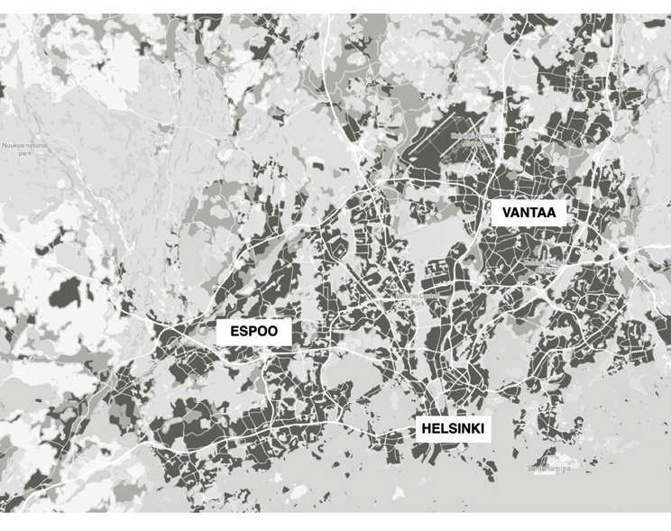
Fig. 1. The Greater Helsinki Region. Darker areas indicate urban population density, lighter areas are less densely populated areas. No density metrics are known, this is a diagram only to show the morphological spatial relationship between the urban areas only
Source: own work.
Helsinki is one of the greenest cities in Europe with greenspaces covering over 40% of the city’s land surface (216.5 sq. km). Urban expansion focused northward and created the basis for the ‘Green Finger’ morphological structure of Helsinki (Fig. 2). The ‘Green Fingers’ include a mixture of former agricultural river valleys, rocky forested ridges, and wetlands that have proved difficult for construction (Vähä-Piikkiö and Maijala, 2003). These ‘Green Fingers’ or linear green structures were established along either a natural corridor and form the backbone of the GHR’s greenspace system.
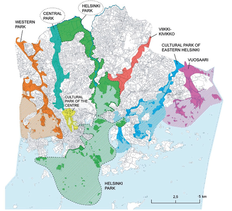
Fig. 2. Diagrammatic plan of the Green Fingers. The Green Fingers’ structure of the Helsinki showing six finger-like parks radiating out from the city centre into surrounding rural areas.
Source: City of Helsinki, 2016.
The interaction of natural and human processes over time has led to the GHR’s landscape fragmentation and development of its distinct green structure, its ‘Green Fingers,’ and the existing spatial characteristic of PUGS, including aspects of connectivity and fragmentation. This study will further qualify and quantify those PUGS spatial characteristics.
Spatial contexts are studied in order to understand an urban region’s morphology and characteristics, including greenspaces. Thus, the term morphology refers to the area of a study’s spatial form and spatial pattern, i.e., spatial structure. This morphological approach is common in landscape analysis (Denis and Marius-Gnanou, 2010; Lynch, 1960).
Two multi-scalar analyses were completed that qualitatively and quantitatively assessed landscape fragmentation and the PUGS spatial characteristics of the GHR:
These two spatial analytical methods complement one another and provide a comprehensive identification of PUGS heterogeneity, diversity, and edge quantity.
A visual analysis was completed through a remote-sensed review at varied scales of the GHR’s peri-urban areas to identify landscape fragmentation primarily assessing spatial heterogeneity, PUGS Diversity, and PUGS edge quantity. This visual analysis was completed by the author, considered an expert in the field of visual landscape analysis, including landscape and greenspace fragmentation characteristics.
A 10 km extension was created around the urban core of Helsinki. This included the ‘Green Fingers’, the GHR, and the polycentric centres of Vantaa and Espoo (see Fig. 3). This area is 974.58 sq. km (974,577,371 sq. m). It served as the study area for data collection, operation, and analysis.
Fig. 3. The Greater Helsinki Region with the two polycentric sub-centres, Espoo and Vantaa. This Figure is for illustrative purposes only. Urban areas of varying densities are illustrated in grey whereas greenspaces of varying types are illustrated in green and yellow-green
Source: EEA CORINE Land Cover Data 2018.
The data collection included CORINE Land Cover (CLC 2018). It consisted of an inventory of land cover in 44 classes. CLC uses a Minimum Mapping Unit (MMU) of 25 hectares (ha) for areal phenomena and a minimum width of 100 m for linear phenomena. The Eionet network National Reference Centres Land Cover (NRC/LC) produces national CLC databases, which are coordinated and integrated by the European Environment Agency (EEA). Finland’s CLC was produced through high-resolution satellite imagery and is regarded as equal to other global land-cover datasets such as Urban Atlas.
The land cover analysis examined the physical characteristics of the landscape through GIS-based data using ArcGIS 10.4; this served as an efficient and effective means to illustrate the three peri-urban fragmentation characteristics of diversity, heterogeneity, and edge quantity. The Level I and Level II land cover classes were analysed in this study. Class I provided a general overview of the various land covers for the region and Class II focussed on the greenspace land cover typologies. All water typologies such as wetlands and inland water bodies were not considered part of the total land area analyses.
It is important to note that the application of a specific landscape fragmentation tool, i.e., FRAGSTATS (McGarigal et al., 2002), was not employed in this multi-method analysis. The GHR’s landscape and its PUGS are already fragmented and facing pressures for further fragmentation; academic and scientific literature has already determined that the Greater Helsinki Region exists in a fragmented state (e.g., Council of Europe, 2000; European Commission, 1999; Kotavaara et al., 2013). The goal for the land cover analysis was to identify the specific PUGS typologies and generate simple statistics in regards to the overall green structure of the GHR.
A visual spatial analysis confirmed that the GHR’s PUGS exhibited the three key landscape fragmentation spatial characteristics of heterogeneity, diversity, and high edge quantity. These multi-scalar results provided not only an overview of the landscape’s PUGS distribution and composition, but their diversity of physical characteristics such as size, shape, edge conditions, composition, as well as varied PUGS typologies – parks, sports facilities, playgrounds, gardens, plazas, etc. Specifically, orthophotos at multiple scales illustrate the PUGS green structure characteristics of interconnection, separation, and overall green structure pattern (see Fig.4 thru 6).
Fig. 4. Green structure interconnection. The GHR’s urbanised areas are separated by large and interconnected PUGS
Scale: Metropolitan Scale (1:200,000)
Source: Google Earth, Digital Globe 2021.
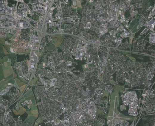
Fig. 5. Green structure separation. PUGS of various and unique sizes, shapes, and typologies are distinct from one another yet also contiguous
Scale: City Scale (1:100,000) (near Vantaa)
Source: Google Earth, Digital Globe 2021.
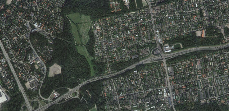
Fig. 6. Morphological Form Impacted through Green Structure Pattern. The GHR’s larger PUGS are often located adjacent to housing developments
Scale: Local Scale (1:20,000) (near Vantaa)
Source: Google Earth, Digital Globe 2021.
The Level I land cover data illustrates green structure and land cover patterns while the Level II land cover data illustrates overall spatial heterogeneity, PUGS diversity, and edge increase. The Class Level I land cover map (see Fig. 7) and results (Table 1) illustrate a simplistic and clear organisation to land cover analysis. The ‘Artificial surfaces’ Class Level I Land Cover is 285,734,892 sq. m. This totals 36.5% for the total land area. These land cover percentages illustrate that the GHR is primarily urbanised within the Helsinki core area and less so as it moves outward. The total Class Level I greenspace areas (Agriculture + Forests and semi-natural) are 496,598,572 sq. m or 63.5% of the total land area. These land cover percentages illustrate that the case study area is primarily ‘green’ in its land cover.
The Class Level II land cover map (see Fig. 8) illustrates the morphology of the GHR, qualitatively and quantitatively documenting overall spatial heterogeneity and landscape fragmentation in its land uses within the region’s three largest land cover areas of Forests, Urban Fabric, and the Industrial, Commercial and Transportation Units. The purpose of this map was to offer an interim step to generally visualise the various land cover typologies before focusing on greenspaces. No land cover totals were provided as they are documented in the other maps and tables within this section.
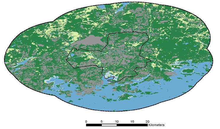
Fig. 7. Class Level I Land Cover
Source: EEA CORINE Land Cover Data 2018.
Table 1. Class Level I land cover
| LAND COVER | AREA [sq m] |
|---|---|
| Artificial surfaces | 285,734,892 |
| Agricultural areas | 110,764,250 |
| Forests and semi-natural areas | 385,834,322 |
| Wetlands | 9,927,819 |
| Water bodies | 182,316,088 |
Source: own work.
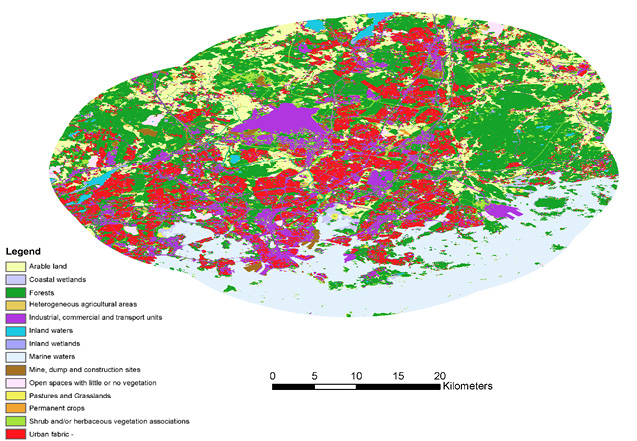
Fig. 8. Class Level II Land Cover
Source: EEA CORINE Land Cover Data 2018.
The Class Level II greenspace land cover map (see Fig. 9) and results (Table 2) analyse greenspace typologies at a finer detail of classification. This map’s Class Level colours were revised to highlight the region’s land cover diversity more clearly.
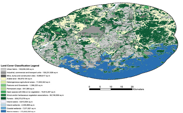
Fig. 9. Class Level II Land Cover – Greenspace Classes
Source: EEA CORINE Land Cover Data 2018.
Table 2. Class Level II land cover – greenspace classes
| LAND COVER | AREA [sq m] |
|---|---|
| ARTIFICIAL SURFACES | 285,734,892 |
| Urban fabric | 149,836,349 |
| Industrial, commercial and transport units | 126,231,926 |
| Mine, dump and construction sites | 9,666,617 |
| GREEN SURFACES | 496,598,572 |
| Arable land | 96,879,104 |
| Heterogeneous agricultural areas | 11,945,342 |
| Pastures and Grasslands | 1,398,220 |
| Permanent crops | 541,585 |
| Open spaces with little or no vegetation | 19,814,287 |
| Shrub and/or herbaceous vegetation associations | 56,746,956 |
| Forests | 309,273,079 |
| WATER SURFACES | 192,243,907 |
| Inland waters | 8,813,554 |
| Inland wetlands | 2,355,898 |
| Coastal wetlands | 7,571,921 |
| Marine waters | 173,502,535 |
Source: own work.
For the Class Level II greenspace land cover data, the landscape is dominated by Forests (309,273,079 sq. m – 30,927 ha) which is almost 40% of the total land area, followed by Arable Land (96,879,104 sq. m – 9,687 ha) then Shrub and/or Herbaceous Vegetation Associations (56,746,956 sq. m − 5,674 ha). The least amount of greenspace land cover types were Permanent Crops (541,585 sq. m − 541 ha), Pastures and Grasslands (1,398,220 sq. m – 1,398 ha), Heterogeneous agricultural areas (11,945,342 sq. m – 1,945 ha), and Open spaces with little or no vegetation (19,814,287 sq. m – 1,981 ha). Clearly, the most prevalent GS landcover in the GHR is Forests. Overall, the highest number of individual GS patches or polygons were Shrub and Herbaceous Vegetation Associations (n=26,400) and Forest (n=16,500). This map illustrates greenspace diversity and edge increase. Qualitatively, the ‘Green Finger’ structure is visible in all Figures of the land cover analysis. It is also noted that there are more naturalistic land covers (Forests, Arable Land, and Vegetation Associations) as the study area expands to the 10 km limit around the urban core.
The results of this study indicate a distinct green structure to the GHR. The two largest fragmented greenspace types, Forest and Arable Land, are interconnected and contiguous to one another and other greenspaces, indicating a green structure pattern and form to its fragmented greenspace. PUGS fragmentation cannot be analysed solely through individual measures or GIS indices; a region’s morphological structure must be understood in order to place its larger spatial context within a perspective, particularly its greenspaces. Though the GHR has large-sized PUGS patches such as Forests, it also has a high number of smaller, compact, complex shaped greenspaces – particularly its Open Space and Shrub and Herbaceous Vegetation parcels, indicating a diffused pattern to its overall greenspace. The GHR’s overall high proximity and less separated greenspaces illustrate a more distinct green structure – those interconnected, contiguous greenspaces – within the region. These results signify that the GHR has fragmented forests and agricultural lands. However, the qualities of this fragmentation are important to note. Though the Forests are fragmented, they are large in size and also connected or proximal often to other large Forest patches. The GHR’s urbanisation and green structure relationship is associated with human development occurring from the urban core of Helsinki to the rural areas. It is these transitional zones where fragmentation (i.e., spatial heterogeneity; Cushman and McGarigal, 2002) is most acute (PLUREL, 2013). It is also in this spatial zone where urban conglomerations arise, here the GHR’s polycentric sub-centres of Espoo and Vantaa.
The historical and existing green structure form has and continues to impact the morphology of the GHR through two distinct characteristics: separation and scale. The GHR’s urbanised areas – their housing and commercial centres – are clearly separated by somewhat large and interconnected greenspaces, often the ‘Green Fingers.’ These characteristics are evident at many spatial scales. The GHR’s larger and more interconnected greenspaces (e.g., forests) often border housing developments and spatially extend for great lengths within the region.
Another significant spatial framework emerges when looking at the region. The hundreds of recreational areas and reserves surrounding Helsinki in a large radius form what has been referred to as the Viherkehä or ‘the Green Ring’ (see Fig. 10). The ‘Green Fingers,’ individually and collectively, serve as a green corridor to the larger regional landscape and the ‘Green Ring,’ linking urban and rural landscape morphologies and land covers.
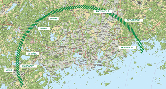
Fig. 10. Diagrammatic plan of the Green Ring. The Green Ring structure of the Region showing large contiguous greenspaces beyond the Green Fingers
Source: Susanna Suvanto, Juha Oksanen, Geodeettinen laitos, Maastotietokanta, Dem ja Maanmittauslaitos.
Within the GHR’s overall fragmented, smaller-sized, more complex, and irregularly shaped greenspaces, the greenspaces still maintain a close proximity and physical connectedness to other greenspaces. The GHR’s smaller, individually-fragmented greenspaces exist within a larger, interconnected context (see Fig. 11).
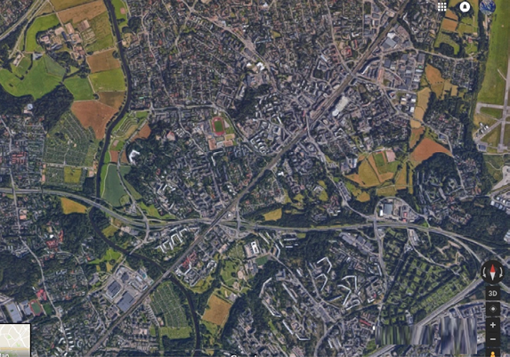
Fig. 11. Orthophoto of GHR showing individually fragmented greenspaces within an interconnected context Within a more fragmented context of smaller-sized and irregularly-shaped greenspaces, the GHR’s greenspaces still maintain a close proximity and physical connectedness to other greenspaces. This is primarily due to the Helsinki ‘Green Finger’ Concept
Source: Google Earth, Digital Globe 2021.
Overall, the GHR has a distinct greenspace composition of connectivity and coherence. The structural composition illustrates a distinct, continuous PUGS surrounding the outer edges of its peri-urban growth. When one considers the water spaces, the typical ‘green belt’ structure ensues. The GHR’s ‘Green Fingers’ extend beyond its boundary designation to create a physical connection from the urban centre of Helsinki to the larger green belt beyond the peri-urban areas and polycentric sub-centres. This greenspace relationship creates a larger ‘Green Mitten’ as an extension of the ‘Green Fingers’ (see Fig. 12).
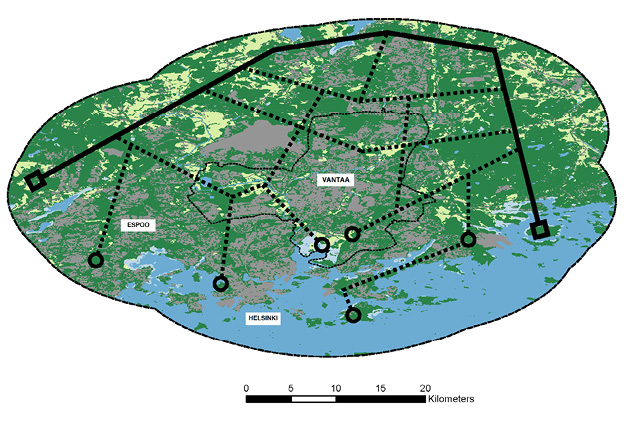
Fig. 12. The Greater Helsinki Region’s ‘Green Mitten.’ The diagram illustrates an extension of the ‘Green Fingers’ into the regional landscape and existing greenbelt
Source: own work.
The ‘Green Fingers’ is a simple concept used for defining the core structure of ‘green’and the PUGS within the GHR. Surprisingly, it does not contain any specific policy instruments to maintain and strengthen the status of this basic structure as it essentially is a group of various municipally-managed greenspaces within a larger, conceptual spatial form (Ahern, 2013). As urbanisation increased, the need for transportation infrastructure bisected the fingers. Ring roads connecting cities and new urban developments along transportation corridors and at the periphery of the sub-centres of Vantaa and Espoo have crossed through large parcels of forest and agriculture (Joutsiniemi, 2010).
The geographical expansion of the GHR has resulted in the fragmentation and isolation of the greenspaces from the larger regional rural green areas (Söderström et al., 2015; Vare and Rekola, 2007), including the ‘Green Ring.’ Spatial planning has not required the greenspace to be a key concept in Finland; typological limitations and unclear definitions of greenspace remain. The term ‘Green Ring’ is not present in any planning or policy documents nor is it prevalent in literature; it has been used only within tourism marketing material.
Finland’s Land Use and Building Act by the Ministry of the Environment (2000) only encourages ‘sustainable development.’ As evidenced, current plans present no clear or definable policy or method to preserve the core areas of the existing public greenspace. Polycentric development patterns have proven beneficial for humans, particularly in their functional and economic basis. For example, greenspace fragmentation occurs within any urbanisation pattern. However, greenspace fragmentation in Helsinki has certain benefits to humans such as increased social interaction (leBrasseur, 2022a) and more opportunities for access (Wandl, 2017). Managing the growth of peri-urban regions is critical to maintaining the inherent benefits, functional and morphological-based, of any regional development concept.
Although most parts of the world, especially in developing countries (e.g., India, China, South America), will see significant urbanisation in emerging megacities and their larger metropolitan conurbations, the European region will continue to accommodate human development predominately through polycentric urban development (Purkarthofer, 2020; EPSON, 2017) within and among its metropolitan regions, a development arrangement which redistributes Europe’s traditionally compact city forms.
The results of this study have implications for other polycentric, peri-urban regions, as well as policy towards meeting sustainable development goals through spatial planning (leBrasseur, 2022b). In a recent study of Stockholm (Sweden) greenspaces, the results indicated pathways to future polycentric development based on current green structure and land cover (Xiu et al., 2016). The study focused on meeting both ecological and social requirements, key to sustainable development. Furthermore, Stockholm’s City Plan (Översiktsplan för Stockholm) considers greenspaces, and how the need for ecosystem services is to be met on the basis of planning directions and strategies in the City Plan and the Environment Programme (Stockholms Stad, 2018). Stockholm’s distinct polycentric urban form includes green wedges and green linkages (Schmitt et al., 2015) and the policy’s aim is that public urban greenspaces have protection and enhancement of biodiversity and green network connectivity. To date (2023), such a policy to prevent urban sprawl and maintain the green structure has been mostly successful; urban densification has been the primary means for accommodating population increase (Hopkins, 2021), similar to the GHR.
Both Beijing and Mexico City are predominately monocentric but their emerging regions are separated by large green structures, thus providing a polycentric urban form at a city scale, and thus the larger regions are considered hybrid (Liu and Liu, 2018; Bautista-Hernández, 2020). In Beijing, China, greenspace fragmentation from 1998 to 2006 followed urbanisation to the north and south, resulting in an overall loss to greenspace with more complex or heterogenous and smaller patches, though several parks were developed (Li et al., 2019). Importantly, the two regional greenbelts underwent fragmentation during different phases of urbanisation; this occurred even with the city’s greenspace planning policies. Similarly, the Mexican government promotes compact growth, mixed land use, and polycentric urban structures. However, in Mexico City, Mexico, this policy has been ineffective (Aguilar et al., 2022) as development has occurred in conservation areas at the urban periphery. Reasons for this are unknown, however, literature has noted the economic benefits of urbanisation are strong, and urban compactness is not associated with economic productivity in Mexico (Montejano et al., 2019). This indicates a need for a better analysis of the relationships between urban growth, green structure, and socio-economic benefits.
Changes to urban form and urban planning policy are a multi-faceted and dynamic exchange. Yet research clearly documents the myriad of benefits greenspaces, and particularly PUGS, provide. Though the pathways to ecosystem services and sustainable development are varied and diverse, this study places PUGS and overall green structure as a component of those goals, not as a valuation tool, within urban development. Future studies can explore these unique relationships in further detail, both from an ecological and human perspective.
This paper has provided a complementary framework for assessing peri-urban greenspace characteristics of fragmentation within the Greater Helsinki Region. It’s multi-method spatial landscape analysis presented a means to assess the morphology of the GHR’s peri-urban regions and their greenspaces, particularly its overall green structure. This paper produced spatial and non-spatial information about the quantity and qualities of landscape fragmentation characteristics within the GHR. The results demonstrated notable spatial heterogeneity, edge increase, and diversity within the GHR’s greenspaces. This research clarified the spatial context and morphological characteristics of the GHR, and its greenspaces, specifically landscape fragmentation and green structure. This research’s operationalisation of green structure focused on its spatial attributes, including separation and interconnectivity.
This study’s conclusions follow the critical analysis of the GHR’s physical and structural change over time and coalesced the many drivers and pressures of spatial landscape change and impacts such as fragmentation on the landscape, all from a distinctly spatial and morphological perspective. The morphologically polycentric GHR has some important PUGS fragmentation characteristics which place its overall greenspace spatial context into perspective: even though the GHR’s Forest and Arable Land greenspaces are the two most fragmented greenspace classes, when reviewing other spatial morphological information, the GHR illustrates greenspaces which are interconnected and contiguous, indicating a green structure pattern and form to its set of peri-urban fragmented greenspaces. Furthermore, the polycentric morphology of the GHR’s urban sub-centres and the ‘Green Fingers’ enable the ‘Green Mitten’ concept to spatially evolve, uniquely creating a coherent intermixed structure. This paper provides the integrated perspective required to view a landscape’s green structure as an evolving regional planning entity in itself – a spatial component – not simply an approach for greenspace connectivity.
The GHR’s spatially interconnected greenspaces are actively facing fragmentation pressures to meet continued human development requirements. There is currently (2022) no policy to maintain the existing structure (e.g., ‘Green Fingers’) of greenspace interconnectivity and coherence within the GHR. As a result of urbanisation, development adjacent to the ‘Green Fingers’, i.e., wedge development, is expected to continue. The evolution and integration of green structure in the GHR continues to balance between the aims of creating a compact region and that of preserving greenspace. Infill development and density offer pathways to sustainable development, but each have their physical limits. Current policy seems not equipped well to objectively manage greenspace from a regional or multi-city perspective. Helsinki and its growing region offer an opportunity to observe how it will engage in sustainable development while maintaining its strong green structure identity.
AGUILAR, A. G., FLORES, M. A. and LARA, L. F. (2022), ‘Peri-urbanization and land use fragmentation in Mexico City. Informality, environmental deterioration, and ineffective urban policy’, Frontiers in Sustainable Cities, 4. https://doi.org/10.3389/frsc.2022.790474
AHERN, J. (2013), ‘Urban landscape sustainability and resilience: the promise and challenges of integrating ecology with urban planning and design’, Landscape ecology, 28 (6), pp. 1203−1212.
ARNAIZ-SCHMITZ, C., SCHMITZ, M. F., HERRERO-JÁUREGUI, C., GUTIÉRREZ-ANGONESE, J., PINEDA, F. D. and MONTES, C. (2018),’ Identifying socio-ecological networks in rural-urban gradients: Diagnosis of a changing cultural landscape’, Science of the Total Environment, 612, pp. 625−635.
ASHRAFZADEH, M. R., KHOSRAVI, R., ADIBI, M. A., TAKTEHRANI, A., WAN, H. Y. and CUSHMAN, S. A. (2020), ‘A multi-scale, multi-species approach for assessing effectiveness of habitat and connectivity conservation for endangered felids’, Biological Conservation, 245, 108523.
BARROS, J. L., TAVARES, A. O., MONTEIRO, M. and SANTOS, P. P. (2018), ‘Peri-urbanization and rurbanization in Leiria city: The importance of a planning framework’, Sustainability, 10 (7), 2501.
BAUTISTA-HERNÁNDEZ, D. A. (2020), ‘Commuting inequality, role of urban structure, and identification of disadvantaged groups in the Mexico City metropolitan area’, Journal of Transport and Land Use, 13 (1), pp. 159−183.
BEER, A. and CLOWER, T. L. (2019), Globalization, planning and local economic development, Routledge.
BERTRAM, C., GOEBEL, J., KREKEL, C. and REHDANZ, K. (2022), ‘Urban Land Use Fragmentation and Human Well-Being’, Land Economics, 98 (2), pp. 399−420.
COLE, D. H. (2015), ‘Advantages of a polycentric approach to climate change policy’, Nature Climate Change, 5 (2), pp. 114−118.
COUNCIL OF EUROPE (2000), ‘European Landscape Convention, ETS 176’, http:www.google.co.uksearchhlenqCouncilofEurope2000landscapeConvention [accessed on: 12.05.2023].
DAVIS, J. S., NELSON, A. C. and DUEKER, K. J. (1994), ‘The new’burbs The exurbs and their implications for planning policy’, Journal of the American Planning Association, 60 (1), pp. 45−59.
De GOEI, B., BURGER, M. J., VAN OORT, F. G. and KITSON, M. (2010), ‘Functional polycentrism and urban network development in the Greater South East, United Kingdom: Evidence from commuting patterns, 1981–2001’, Regional Studies, 44 (9), pp. 1149−1170.
DENIS, E. and MARIUS-GNANOU, K. (2010), ‘Toward a better appraisal of urbanization in India. A fresh look at the landscape of morphological agglomerates’, Cybergeo: European Journal of Geography. https://doi.org/10.4000/cybergeo.24798
DORPH, A., SWAN, M., Di STEFANO, J. and PENMAN, T. D. (2021), ‘Relating mammal species richness to landscape patterns across multiple spatial scales’, Landscape Ecology, 36, pp. 1003−1022.
ESPON (2017), Between cooperation and competition: why polycentric development matters, https://www.espon.eu/polycentricity-2017 [accessed on: 12.05.2023].
EUROPEAN COMMISSION (1999), ESDP. European Spatial Development Perspective. Towards Balanced and Sustainable Development of the Territory of the European Union. Luxembourg: European Communities.
FINKA, M. and KLUVÁNKOVÁ, T. (2015), ‘Managing complexity of urban systems: A polycentric approach’, Land Use Policy, 42, pp. 602−608. https://doi.org/10.1016/j.landusepol.2014.09.016
GAO, J. (2020), ‘Editorial for the Special Issue «Ecosystem Services with Remote Sensing»’, Remote Sensing, 12 (14), 2191.
GRANQVIST, K., SARJAMO, S. and MÄNTYSALO, R. (2019), ‘Polycentricity as spatial imaginary: The case of Helsinki City Plan’, European Planning Studies, 27 (4), pp. 739−758.
GRIGONIS, V. (2013), World cities and urban form: Fragmented, polycentric, sustainable?, Springer.
HADDAD, N. M., BRUDVIG, L. A., CLOBERT, J., DAVIES, K. F., GONZALEZ, A., HOLT, R. D. and TOWNSHEND, J. R. (2015), ‘Habitat fragmentation and its lasting impact on Earth’s ecosystems’, Science advances, 1 (2), e1500052.
HALL, P. G. and PAIN, K. (eds.) (2006), The polycentric metropolis: Learning from mega-city regions in Europe, Routledge.
HARDT, E., PEREIRA-SILVA, E. F., DOS SANTOS, R. F., TAMASHIRO, J. Y., RAGAZZI, S. and LINS, D. B. D. S. (2013), ‘The influence of natural and anthropogenic landscapes on edge effects’, Landscape and Urban Planning, 120, pp. 59−69.
HE, S., YU, S., LI, G. and ZHANG, J. (2020), ‘Exploring the influence of urban form on land-use efficiency from a spatiotemporal heterogeneity perspective: Evidence from 336 Chinese cities’, Land Use Policy, 95, 104576.
HAUTAMÄKI, R. (2016), Urban Manors: Urbanisation, Preservation and Integration of Helsinki’s Manors within the Urban Structure, pp. 175–192.
HEROLD, M., HEMPHILL, J., DIETZEL, C. and CLARKE, K. C. (2005, March), ‘Remote sensing derived mapping to support urban growth theory’, [in:] 3rd international symposium remote sensing and data fusion over urban areas (URBAN 2005) and 5th international symposium remote sensing of urban areas (URS 2005).
HOPKINS, R. A. (2021), ‘Public urban green space: Exploring priorities and challenges for managing and valuing green space, using Stockholm as a case study.’
IAQUINTA, D. L. and DRESCHER, A. W. (2000), ‘Defining the peri-urban: rural-urban linkages and institutional connections’, Land reform, 2, pp. 8−27.
JOUTSINIEMI, A. (2010), Becoming metapolis-A configurational approach, Tampereen teknillinen yliopisto.
KLOOSTERMAN, R. C. and LAMBREGTS, B. (2001), ‘Clustering of economic activities in polycentric urban regions: the case of the Randstad’, Urban Studies, 38 (4), pp. 717−732.
KOTAVAARA, O., ANTIKAINEN, H. and RUSANEN, J. (2013), ‘Accessibility patterns: Finland case study’, Europa XXI, 24, pp. 111−127.
KOWE, P., MUTANGA, O. and DUBE, T. (2021), ‘Advancements in the remote sensing of landscape pattern of urban green spaces and vegetation fragmentation’, International Journal of Remote Sensing, 42 (10), pp. 3797−3832.
KUPFER, J. A. (2006), ‘National assessments of forest fragmentation in the US’, Global Environmental Change, 16 (1), pp. 73−82.
La ROSA, D. and PRIVITERA, R. (2013), ‘Characterization of non-urbanized areas for land-use planning of agricultural and green infrastructure in urban contexts’, Landscape and Urban Planning, 109 (1), pp. 94−106.
leBRASSEUR, R. (2022a), ‘Linking Human Wellbeing and Urban Greenspaces: Applying the SoftGIS Tool for Analyzing Human Wellbeing Interaction in Helsinki, Finland’, Frontiers in Environmental Science, 1580.
leBRASSEUR, R. (2022b), ‘A refined literature review to promote sustainable development through integrated frameworks in the European landscape’, Journal of European Landscapes, 3 (3), pp. 61−78.
LEITÃO, A. B., MILLER, J., AHERN, J. and MCGARIGAL, K. (2012), Measuring landscapes: A planner’s handbook, Island press.
LI, F., ZHENG, W., WANG, Y., LIANG, J., XIE, S., GUO, S., LI, X. and YU, C. (2019), ‘Urban green space fragmentation and urbanization: A spatiotemporal perspective’, Forests, 10 (4), 333.
LIAO, W., HONG, T. and HEO, Y. (2021), ‘The effect of spatial heterogeneity in urban morphology on surface urban heat islands’, Energy and Buildings, 244, 111027.
LIU, Z. and LIU, S. (2018), ‘Polycentric development and the role of urban polycentric planning in China’s mega cities: An examination of Beijing’s metropolitan area’, Sustainability, 10 (5), 1588.
LYNCH, K. (1960), The image of the city, 11, MIT press.
MCCARIGAL, K., CUSHMAN, S. A., NEEL, M. C. and ENE, E. (2002), ‘FRAGSTATS: Spatial pattern analysis program for categorical maps, version 3.0’, University of Massachusetts, Amherst, Massachusetts.
MCGARIGAL, K. and MARKS, B. J. (1995), ‘Spatial pattern analysis program for quantifying landscape structure’, Gen. Tech. Rep. PNW-GTR-351. US Department of Agriculture, Forest Service, Pacific Northwest Research Station, pp. 1−122.
MEIJERS, E., HOOGERBRUGGE, M. and CARDOSO, R. (2018), ‘Beyond polycentricity: Does stronger integration between cities in polycentric urban regions improve performance?, Tijdschrift voor economische en sociale geografie, 109 (1), pp. 1−21.
MILLENIUM ECOSYSTEMS ASSESSMENT (MEA) (2005), Ecosystems and human well-being: wetlands and water, World Resources Institute.
MINISTRY OF THE ENVIRONMENT (2000), Land Use and Building Act, https://ym.fi/en/land-use-and-building-act [accessed on: 27.01.2023].
MITCHELL, M. G., BENNETT, E. M. and GONZALEZ, A. (2015), ‘Strong and nonlinear effects of fragmentation on ecosystem service provision at multiple scales’, Environmental Research Letters, 10 (9), 094014.
MITCHELL, M. G., SUAREZ-CASTRO, A. F., MARTINEZ-HARMS, M., MARON, M., MCALPINE, C., GASTON, K. J., JOHANSEN, K. and RHODES, J. R. (2015), ‘Reframing landscape fragmentation’s effects on ecosystem services’, Trends in ecology & evolution, 30 (4), pp. 190−198.
MONTEJANO, J., MONKKONEN, P., GUERRA, E. and CAUDILLO, C. (2019), The Costs and Benefits of Urban Expansion: Evidence from Mexico, The Lincoln Institute of Land Policy, Working Paper WP19JM1.
MULLU, D. (2016), ‘A review on the effect of habitat fragmentation on ecosystem’, Journal of Natural Sciences Research, 6 (15), pp. 1−15.
NAIKOO, M. W., RIHAN, M., PEER, A. H., TALUKDAR, S., MALLICK, J., ISHTIAQ, M. and RAHMAN, A. (2022), ‘Analysis of peri-urban land use/land cover change and its drivers using geospatial techniques and geographically weighted regression’, Environmental Science and Pollution Research, pp. 1−19.
NILSSON, K., NIELSEN, T. S., AALBERS, C., BELL, S., BOITIER, B., CHERY, J. P. and ZASADA, I. (2014), ‘Strategies for sustainable urban development and urban-rural linkages’, European Journal of Spatial Development, 12 (3), pp. 1–26.
OFFICIAL STATISTICS OF FINLAND-OSF (2018), Population structure [Internet]. Helsinki: Statistics Finland, http://www.tilastokeskus.fi/til/vaerak/tau_en.html [accessed on: 27.01.2023]
PAN, Y., QIU, L., WANG, Z., ZHU, J. and CHENG, M. (2022), ‘Unravelling the association between polycentric urban development and landscape sustainability in urbanizing island cities’, Ecological Indicators, 143, 109348.
PAUDEL, S. and YUAN, F. (2012), ‘Assessing landscape changes and dynamics using patch analysis and GIS modeling’, International Journal of Applied Earth Observation and Geoinformation, 16, pp. 66−76.
PURKARTHOFER, E. (2020), ‘The enticement of the ESDP: Motivating (future) planners to engage with EU policies’, Transactions of the Association of European Schools of Planning, 4 (2), pp. 133−145.
PIORR, A. (ed.) (2013), Peri-urbanisation in Europe: towards European policies to sustain urban-rural futures; synthesis report; PLUREL [sixth framework programme], Forest & Landscape, University of Copenhagen.
PLUREL (2013), ‘In Peri-urbanisation in Europe. Towards European Policies to Sustain Urban–Rural Futures’, [in:] PIORR, A, R. J. and TOSICS, I (ed.), Copenhagen, Denmark: Forest & Landscape, University of Copenhagen.
RANALLI, F. and SALVATI, L. (2015), ‘Land-Use Structure and Urbanization-Driven Land Fragmentation: Revisiting the Monocentric Model in a Sprawling Region’, European Spatial Research and Policy, 22 (1), pp. 61−80.
RECANATESI, F. (2015), ‘Variations in land-use/land-cover changes (LULCCs) in a peri-urban Mediterranean nature reserve: the estate of Castelporziano (Central Italy)’, Rendiconti lincei, 26, pp. 517−526.
ROBINSON, D. T. (2012), ‘Land-cover fragmentation and configuration of ownership parcels in an exurban landscape’, Urban Ecosystems, 15, pp. 53−69.
SANDSTRÖM, U. G. (2002), ‘Green infrastructure planning in urban Sweden’, Planning, Practice and Research, 17, pp. 373−385.
SCHEWENIUS, M., MCPHEARSON, T. and ELMQVIST, T. (2014), ‘Opportunities for increasing resilience and sustainability of urban social–ecological systems: insights from the URBES and the cities and biodiversity outlook projects’, Ambio, 43, pp. 434−444.
SCHMITT, P., VOLGMANN, K., MÜNTER, A. and REARDON, M. (2015), ‘Unpacking polycentricity at the city-regional scale: Insights from Dusseldorf and Stockholm’, European Journal of Spatial Development, 59, pp. 1−26.
SHI, F., LIU, S., AN, Y., SUN, Y., ZHAO, S., LIU, Y. and LI, M. (2020), ‘Spatio-temporal dynamics of landscape connectivity and ecological network construction in Long Yangxia basin at the upper Yellow river’, Land, 9 (8), 265.
SINGH, S. K., PANDEY, A. C. and SINGH, D. (2014), ‘Land use fragmentation analysis using remote sensing and Fragstats’, [in:] Remote sensing applications in environmental research, pp. 151−176, Cham: Springer.
SÖDERSTRÖM, P., SCHULMAN, H. and RISTIMÄKI, M. (2015), Urban form in the Helsinki and Stockholm city regions-Development of pedestrian, public transport and car zones.
STOCKHOLMS STAD, (2018), English version of Stockholm City Plan, https://vaxer.stockholm/tema/oversiktsplan-for-stockholm/ [accessed on: 11.01.2023].
SÝKORA, L., MULÍČEK, O. and MAIER, K. (2009), City regions and polycentric territorial development: concepts and practice.
VÄHÄ-PIIKKIÖ, I. and MAIJALA, O. (2003), Case Study Helsinki.
VARE, S. and REKOLA, L. (2007), Large contiguous forest areas as part of the ecological network of Uusimaa Region, Helsinki, Finland: Uusimaa Regional Council.
WANDL, A. (2017), ‘Comparing the landscape fragmentation and accessibility of green spaces in territories-in-between across Europe’, Urban Planning, 2 (4), pp. 25−44.
WANDL, A. (2012), ‘Can Landscape Urbanism Help to Plan in «Territories-in-Between»’, Atlantis, 22 (4), 2012.
WATERHOUT, B. A. S., ZONNEVELD, W. I. L. and MEIJERS, E. (2005), ‘Polycentric development policies in Europe: Overview and debate’, Built Environment (1978-), pp. 163−173.
XIU, N., IGNATIEVA, M. and KONIJNENDIJK VAN DEN BOSCH, C. (2016), ‘Planning and Design of Urban Green Networks in Stockholm’, Proceedings of the Fábos Conference on Landscape and Greenway Planning, 5 (1) , Article 4.
XU, C., HAASE, D. and PAULEIT, S. (2018), ‘The impact of different urban dynamics on green space availability: A multiple scenario modeling approach for the region of Munich, Germany’, Ecological Indicators, 93, pp. 1−12.
ZAMBRANO, L., ARONSON, M. F. and FERNANDEZ, T. (2019), ‘The consequences of landscape fragmentation on socio-ecological patterns in a rapidly developing urban area: a case study of the National Autonomous University of Mexico’, Frontiers in Environmental Science, 7, 152.