

Abstract. The paper contributes to European comparative research on spatial planning by providing an instrument-oriented methodological framework for forms of spatial planning. Based on the main efforts to date, the main challenges of comparative research on European planning systems are identified. The multi-dimensional nature of spatial planning, language barriers, the diversity of planning practices within national systems, the emergence of informal practices, and the dynamic changes of forms are the main limitations of the comparison. The author introduces a comparative four-dimensional model and related visual tool that can be used to bridge different national languages and practices of planning and compare various forms of spatial planning. With the tool, the nature of planning regimes, specific plans, and other planning-related activities can be identified in accordance with the dimensions of Motivation, Geography, Scope, and Instruments, making them comparable. Drawing on literature on European trends in spatial planning, the model can be used to capture both old and new forms of planning.
Key words: spatial planning, urban planning, European Union, territorial governance, comparative studies.
Regional planning, urban planning, and other public mechanisms that address the shaping of spatial development take different forms worldwide. Planning systems aimed at spatial development are quite different, even within the EU. The territorial levels, instruments, professional-disciplinary bases, and even the fundamental mission of planning may be totally different. These differences can be traced back to the variation in the constitutional and institutional arrangements, political ideologies, and geographical and cultural characteristics of countries. In fact, even the terms used in the national languages of Member States for various fields of spatial planning cannot be fully translated into other languages because of their deep embeddedness in country-specific contexts. Despite some efforts, regional and urban planning have not become part of the community policy of the European Union (Faludi, 2011), although many EU policies and increasing cooperation among Member States indirectly but effectively influence the planning practices of the latter (Dallhammer et al., 2018). Despite this process (called Europeanisation) and the fact that planning faces the same global challenges, most authors (e.g. Purkarthofer, 2016; Stead, 2013; Böhme and Waterhout, 2008) agree that there has been no obvious convergence among the spatial planning systems of the respective countries and, as Nadin has stated (2012), Europe still has many varieties of planning which – despite reform and Europeanisation – remain distinctive.
As European integration has progressed, the need to link different national spatial planning systems has grown as EU policies increasingly require the coordination of territorial development. Moreover, the implementation of EU policies like Cohesion Policy and EU agendas like the Green Deal, smart growth, etc., require the integrated contribution of spatial planning at various levels. This European interest in spatial planning has triggered extensive international cooperation and exchange concerning planning mechanisms and policies (Dühr et al., 2010) during the last three decades. The cross-national comparison of spatial planning is increasingly demanded due to the single market of the EU, the necessity of reacting jointly to global challenges, the multi-level governance exerted within the EU, and the increasing need for cross-border cooperation related to spatial development.
These developments have generated a wave of comparative policy research in Europe since the 2000s, spurred by research funding from EU research framework programs that often require international collaboration and comparison. Other EU funding has been specifically targeted spatial planning – notably, the INTERREG and ESPON programmes, which fund targeted research, together with direct funding from EU and Council of Europe institutions, especially for evaluating the impact of EU policies in Member States (Nadin, 2012). Other authors (Verweij and Trell, 2019; Assche et al., 2020) emphasize that the need for learning from other planning systems is a demand for comparison. Not surprisingly, international comparative subjects are now starting to be introduced into planning education, too (Othengrafen and Galland, 2019).
The first condition for comparing different spatial planning systems has been the establishment of a common European conceptual framework. In the past three decades, the term ‘spatial planning’ has expanded to uniformly cover and highlight various styles of spatial planning that are present in Europe (in its emergence see Williams, 1996; Tewdwr-Jones, 2001; Kunzmann, 2006). Although this concept emerged as a result of policy efforts, the researchers of the development and institutionalisation of Europe-wide spatial planning have played an important role in the academic conceptualisation of the term (Böhme, 2002; Faludi and Waterhout, 2002; Faludi, 2004, 2011; Janin Rivolin, 2012; Kunzmann, 2006). In European institutions since the early 2000s, there has been a shift in the terms used to imply the coordination or integration of the territorial impacts of sectoral policies – from ‘spatial planning’ through ‘spatial development’ to ‘territorial governance’ (ESPON, 2018, p. 8) (Territorial governance expresses more the coordinating nature and multi-actor character of shaping spatial development, although in this paper, the broader meaning of ‘spatial planning’ is used, which includes territorial governance[1]). Besides its other interpretations, spatial planning has become a neutral umbrella concept – as applied in this paper – that encompasses both the different planning concepts of different countries and, in addition to more traditional urban and regional planning, other public coordination mechanisms that address spatial (including urban) development (from transport planning to place-based economic and community development to the spatial coordination of sectoral policies), while spatial plans at different geographical scales, from the local to the national and even transnational regions, are also part of this (Salamin and Péti, 2019).[2]
The diversity of planning can be experienced not only among countries, but their nature and character also change over time mainly due to the necessity to respond adaptively to changing societal and political conditions[3] resulting in new forms of plannings.
The goal of the paper is to methodologically contribute to attempts at comparing various forms of spatial planning by proposing an instrument-oriented comparative model – a ‘map’ of spatial planning forms. This model and its visual tool enable the comparative identification of the nature of specific plans, planning regimes, and planning in a broader sense, and to differentiate traditional and new forms of planning that are being understood in line with European spatial planning trends. The methodology behind the development of the tool includes the identification of the possible forms of planning and a review of European empirical comparative studies on spatial planning to identify the current challenges of comparative research in this field. The proposed model reflects on some of these challenges, and some illustrations of the use of the tool are also provided. Besides the analysis of European spatial planning literature, consultations with experts (see acknowledgements) on European planning systems and the author’s domestic and international planning experience were essential for understanding the various aspects of planning and validating the author’s assumptions.
While the need for comparing different national policies is as old as European integration, the systemic comparison of spatial planning systems started in the early 1990s and gained particular momentum in the mid-2010s (See Davies et al., 1989; Newman and Thornley, 1996; ECE, 1997; Farinós Dasí, 2006; Reimer et al., 2014). The analysis of these classifications by Nadin and Stead (2012, 2013) and Nadin (2012) led to significant progress in understanding the interpretations of comparative studies. Several theoretical frameworks[4] have been developed to conceptualise how spatial planning systems and cultures may be compared: Ernste suggested the frame analysis of planning cultures (2012); Janin Rivolin proposed the consideration of planning systems as institutional technologies to be relevant grounds for comparison (2012); Servillo and Broeck introduced a strategic-relational institutionalist approach (2012); and Reimer and Blotevogel (2012) and Knieling and Othengrafen (2016) argued for the analysis of planning cultures. In what follows, we focus on the methods applied in the main empirical studies, particularly the aspects they considered relevant for comparisons. Various small-scale comparative studies have provided in-depth analyses of two or three systems, but very few studies have attempted a more comprehensive comparison of a large number of planning systems (Nadin and Stead, 2013).
Nadin and Stead (2013) distinguished two approaches to constructing typologies for planning systems: classifications based primarily on legal and administrative structures, and typologies that use ‘ideal types.’[5] In the first approach, comparing the characteristics of planning ‘systems’ can be used to systematically classify or categorise systems in a mutually exclusive and exhaustive way. Thus, each system is allocated to one category only. It should be possible to categorise all systems, but in practice, a meaningful categorisation of complex planning systems is very difficult. Systems may, for example, be similar according to some criteria but dissimilar according to other. Nadin and Stead (2013) analysed and drew up the first empirical classifications on the basis of legal-institutional aspects, defining the legal ‘families’ of planning: Davies et al. (1989) distinguished the planning systems of Common Law in England and the Napoleonic codes of continental Europe, while Newman and Thornley (1996) distinguished Nordic, British, Germanic and Napoleonic, and East European groups. The ‘ideal-types’ approach was introduced in 1997 by the Commission of the European Communities’ (CEC) report entitled The EU compendium of Spatial Planning Systems and Policies (Compendium), which represented the most powerful typology-driven approach to date. This study was born in response to the increasing demand for the coordination of national spatial planning practices from the 1990s onwards – a period Faludi (2011) called the ‘Boom era’ of European spatial planning. The compendium introduced four distinctive planning types specified as traditions in Europe. The land-use management tradition focuses on the regulation of changes in the use of land; regional economic planning concerns the pursuit of a wide range of socioeconomic objectives, focusing on managing development processes and public investment; in the comprehensive integrated tradition, a systemic and formal hierarchy of plans focus on coordinating different sectors to support spatial coordination; finally, the urbanism tradition has a strong architectural flavour and is concerned with urban design, townscapes, and building control (for details, see Table 2). These traditions were developed as ideal types and applied in the study as measures against which the reality in Member States could be compared. As Nadin – one of the authors of the Compendium – has claimed, national planning systems in all Member States show some degree of affiliation with all four traditions. However, they are more closely related to certain traditions than others. The Compendium applied seven variables for analysis: (1) legal family context, (2) scope in terms of policy topics, (3) the extent of national and regional planning, (4) the locus of power and distribution of competence between central and local government, (5) the relative roles of public and private sectors, (6) the maturity of the systems (i.e., how well they are established in government and public life), and (7) the apparent distance between the expressed spatial development goals and the outcomes (Nadin and Stead, 2013) (Table 1). It is important to recognise that the final two aspects involve judgement about the quality of the systems, which infers the sensitive issue of making political critiques when comparing countries.
| Spatial planning traditions/models | Legal family | Scope | National and regional planning | Locus of power | Public or private | Maturity | Distance |
|---|---|---|---|---|---|---|---|
| Regional economic planning | Mixed | Wide | National planning | Centre and local | Public | Mature | Mixed |
| Comprehensive integrated | Mixed | Wide | Multi-level | Mixed | Public | Mature | Narrow |
| Land-use management | Discretion | Narrow | Local | Centre | Mixed | Mature | Narrow |
| Urbanism | Code | Narrow | Local | Local | Mixed | Immature | Wide |
In the mid-2000s, the ESPON 2.3.2 project entitled the Governance of Territorial and Urban Policies from Local to EU level (Farinós Dasí, 2006) represented the second comprehensive comparative analysis at the European level. It used the four models of the Compendium and modestly updated them with developments that had taken place since then, also including the new Member States at that time and Switzerland and Norway (as partners in the ESPON programme). By revealing the shifts between models employed by countries, it moved the focus on planning from a static system to the dynamics of change. In this report, Farinós Dasí et al. proposed a three-dimensional approach to identify the characteristics of spatial planning systems (Fig. 1): (1) Level (from local to supra-national), (2) Style (including the models of the Compendium), and (3) Focus of planning in relation to the scope (physical, economic, environmental). For each dimension, the soft vs. hard dichotomy was introduced. In the authors’ understanding, the terms ‘hard’ and ‘soft’ referred to how instruments and rules in spatial planning were more (‘hard’) or less (‘less’) formal and clearly (closed) established from a legislative or juridical point of view. Higher levels and more comprehensive integrated models were understood as ‘softer’.
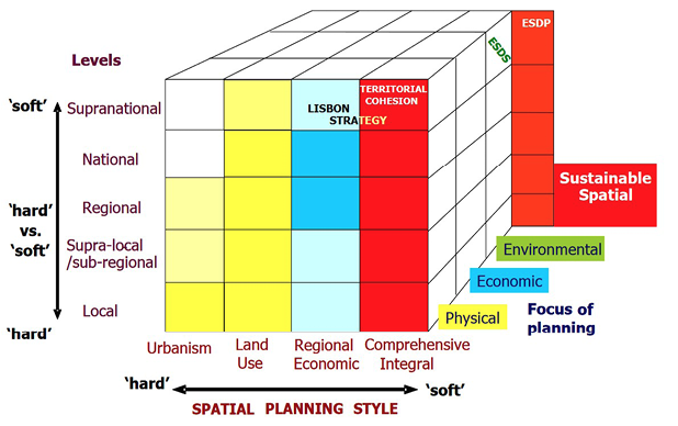
Fig. 1. Dimensions of identifying spatial development planning using the ESPON 2.3 approach
Source: Farinós Dasí (2006, p. 110).
As one of the results of the ESPON COMPASS research project (2018) Berisha et al. (2021) created a more focused classification of European spatial governance and planning systems according to the latter’s capacity for public control over spatial development. Based on the analysis of the relation to the mechanisms to allocate land use and spatial development rights as well as to the prevalence of the state vs. the market in guiding the development decisions in the planning systems, they classified the systems of 39 countries in an exclusive and exhaustive manner. By this work this type of distinctive classification has proved to be more appropriate in the case of such a focused comparison, than in a more general comparison.
Various authors have drawn attention to various limitations of former classifications. Getimis (2012) has emphasized the need for a multi-scalar approach to understanding spatial planning and has claimed that comparative analysis should focus on the changes emerging in actor arenas at different scales of planning practices (project/local, city, regional, cross/border, and national level). In Reimer’s and Botevogel’s (2012) view, the category of ‘national planning system’ – which inherently implies an internal homogeneity – masks a natural diversity of planning practices and forms and, as a deterministic structure, exhibits a high degree of resistance to the processes of transformation. In reality, planning practices vary widely even within countries. Classifications based on legal traditions are rigid and fail to describe reality well because planning practices are characterised by a wide range of different forms of planning activities. Recent decades have seen a rise in the importance assigned to the forms of planning which are not based on coercion as the modus of the coordination of action but rather on bargaining, consensus, and agreement. The integration of new actors and the pressure to embrace an intersectoral approach to the planning action suggest that established forms of spatial planning are being supplemented with new action logics, resulting in a high degree of local variation. Reimer and Botevogel have stated that a culture-oriented perspective is more appropriate, which explicitly addresses the diversity of planning activities and the various related practices, mechanisms, and principles associated with the individual systems. The authors thus proposed four core cultural aspects of planning that they recommended for future research: (1) traditions of action, (2) processes of self-perception and constructing reality, (3) adaptation and learning, and (4) established power structure (Reimer and Botevogel, 2012).
At this point, it is important to note that measuring these aspects is more likely to be possible using small-scale in-depth analysis – for example, as in the several case studies introduced in Othengrafen’s book (2016) – but large-scale comparative studies that employ this approach have not yet been delivered due to the challenges of measurement and quantification.
Due to the highly complex nature of spatial planning, the cross-country comparison of spatial planning faces several limitations. Based on the consequences of the experiences above and the conclusions of Nadin and Stead (2013), as well as the final report of the COMPASS (ESPON, 2018) project, the following challenges may be identified:
All of the above highlight the methodological difficulties involved in appraising planning systems in a reliable manner and preferably in a quantifiable way. Due to the complexity of planning and the limitations of resources, for studies covering large number of countries the main information sources are typically the expert opinions gathered through surveys or interviews, which method may entail the risk of subjectivity (Nadin et al., 2021). However, the analysis of planning documents has also occurred in more targeted studies (see Perić et al. 2021; Salamin, 2018). For a case-oriented comparative research (e.g., a project), more qualitative methods can be used, such as the Qualitative comparative analysis (QCA) recommended and analysed by Verweij and Trell (2019) and Assche et al. (2020).
In order to identify new forms, it is worthwhile examining the main transformational trends in planning. Making a comprehensive analysis of the contemporary trends in spatial planning is not the ambition of this paper, although there is such a rich European literature about the dynamics of the last decades that the main characteristics of a simplified new spatial planning approach can be identified (in contrast to more traditional forms). The European spatial planning trends can be captured by three processes that appear in the planning literature as distinct, trending topics: first, the prominence of the more flexible and multi-actor governance in contrast to government (see Fürst, 2009; Getimis, 2012; Stead and Cotella, 2011; Stead and Pálné, 2016; Van Well and Schmitt, 2016). Second, the appearance of new spaces of planning, which are often soft spaces with fuzzy boundaries that are related also to the increasing multi-scalar character of planning systems (see Allmendinger and Haughton, 2009; Faludi, 2013; Gänzle and Kern, 2016; Heley, 2013; Metzger and Schmitt, 2012; Walsh, 2014, etc.). Third, the impact of the EU, as Europeanisation, which influences the understanding, instruments and spaces, and scales and methods of domestic spatial planning – about which Faludi (2011) wrote and which Salamin (2018) attempted to make measurable. All these processes may be associated with the issues of post-modern, post-structuralist philosophy (multiple interpretations, narratives, relational space, etc.) (Allmandinger, 2000, 2016; Haughton et al., 2010).
In order to make these changes tangible and identifiable from a comparative perspective, we attempt to identify the ideal ‘new spatial planning’ using a significant simplification. Within the framework of this study, we may only list the main characteristics of this that result from the latter trends based mainly on the work of Böhme and Waterhout (2008), Cotella and Janin Rivolin (2011), Dühr, Colomb, and Nadin (2010), ESPON (2018), Faludi (2011), Getimis (2012), Nadin (2006), Salamin (2018), and Salamin and Péti (2019) in particular. Namely, the new spatial planning:
This[9] new planning approach is intensely inspired by the EU strategies and territorial cooperation programs, especially the awareness-raising ESPON and URBACT programmes (see Perić et al., 2021; Luukkonnen, 2011; Faludi, 2011; and Salamin, 2018).
The model described below is based on the assumption that the nature of spatial planning action(s) should be described in parallel in different dimensions which do not necessarily interact. Instead of quantitatively combining different variables into a complex indicator, with the model it becomes possible to visually compare several factors simultaneously (after all, human perception using the visual dimension is considerably better than when it comes to understanding text or numbers). The other starting point is that before extensive investigations of legislative and institutional systems and cultural contexts, and other systems that include spatial planning – which are resource-consuming – perceptible forms of planning can be analysed (planning instruments in particular) through their tangible manifestations (such as plans, activities) that can provide meaningful information about the entire planning system. The visual synthesis of potential planning forms is presented in Fig. 2. The definitions of spatial planning in specific countries and organisations are different: most national practices do not include all the types included in Fig. 2 as part of their spatial planning system or understanding of the latter. Accordingly, Fig. 2 represents the widest European interpretation of spatial planning as an umbrella term.
To make various forms of planning comparable, four dimensions of the characteristics of spatial planning have been selected for the model called the Planning Map: Mission, Geography, Scope, and Instruments. In the understanding of this model, the concept of planning form refers to the representation of planning actions in these four dimensions. Given the large number of variables that could be used to describe the nature of spatial planning, the choice of four may seem too limited. However, those that have been selected are strongly connected to other dimensions. For instance, geographical levels and spaces are normally interconnected with the legal system (the locus of power) and institutions and with the existence of a governance approach (as new governance approach creates more soft and flexible spaces of planning).
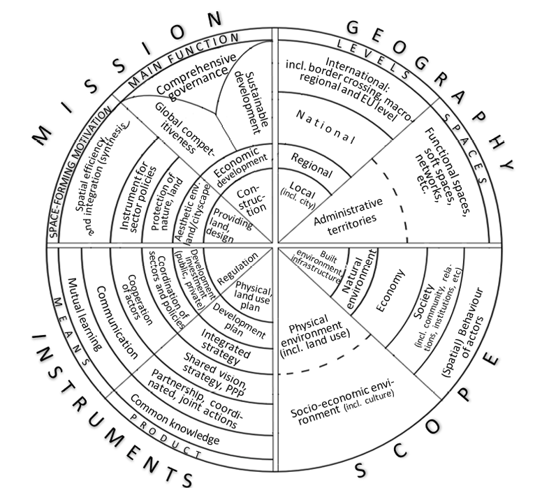
Fig. 2. Map of spatial planning forms (Planning Map): The potential types of spatial planning activities according to four dimensions
Source: own work based on European planning literature.
The mission of planning is related to the goals and approaches of legally defined institutions and legitimate policy agendas and to the characteristics of the planning profession (e.g., its country-specific disciplinary). The general motivation for planning in a country is influenced by several cultural aspects, too, which may represent essential information about the position of this policy branch in the policy system. In the dimension of instruments, traditional hard instruments reflect legislation, while the existence of softer ones may indicate the existence of a new governance approach, participation and cultural characteristics, while the specific planning professional approach and the applied methods of planning are reflected in the types of instruments in every case. Additionally, the existence of different forms of planning instruments may also inform about the role of spatial coordination in policy practices and the relationship between the public and private sectors (e.g., regulatory tools can only limit public and private actors, while integrated strategies, and forms of cooperation in particular, can support partnerships). The scope reflects the actual professional-scientific approach and the function of spatial planning in the governance of a country, region, or city.
The potential forms within each dimension have been elaborated on the basis of the European planning literature – which tends to understand spatial planning and its new form, often called territorial governance, more and more broadly – and on the 15 years of planning experience of the author, while consultation with key European experts in the field (see the acknowledgements) also supported this work.
The Planning Map is designed to allow the user to distinguish between traditional and new forms of planning. The new planning trends (described in Chapter 3) of the last three decades represent changes in all four planning-grouping dimensions. In Fig. 2, forms of planning near the centre of the circle are typically associated with the more traditional and typically hard planning practices but are accompanied by newer forms over time. These new forms – in line with the changes documented in the literature – are indicated by a shift from the centre towards the outside of the wheel in the case of all the dimensions that appear as sectors. The forms of planning closer to the periphery are typically soft forms and may be associated more with the approach of territorial governance.
‘Mission’ is understood as the broader societal function with which the spatial planning action is associated. It answers the very essential question “why” concerning the existence of specific planning. The rationale for the creation/ operation/ development of planning has changed slowly on a historical scale, although in recent decades it has been more rapid. It has shifted from the task of managing the construction of cities through developing a liveable urban environment to supporting economic prosperity, while nowadays, supporting competitiveness is often a key driver. Most recently, the most important mission has been to promote sustainable development – an endeavour which spatial planning could, in theory, perhaps do the most to achieve (Péti, 2011)[10]. In line with the new approach, spatial planning appears as a harmonisation of actors and policies that influence spatial development (with the participation of considerably more people) rather than the preparation of regulated planning documents that may prevail at different scales and in a variety of spaces.
The dimension of ‘Geography’ is meant here as the geographical reference area of the planning activity.[11] This can vary according to different territorial levels, but the place of planning can be administrative (with legally defined borders) in nature or functional. Spatial planning has recently emerged at larger spatial scales, and as described above, new soft functional spaces with fuzzy boundaries, and even networks are increasingly becoming the units of planning processes. However, as many authors highlight (Allmendinger et al., 2015; Metzger and Schmitt, 2012; Zimmerbauer and Paasi, 2019; Smas and Schmitt 2021), the appearance of new spaces does not result in the elimination of traditional, formal planning spaces (administrative units), but rather supplements them. It is important to note that these trends in the geographies of planning do not have obviously one way direction, as soft spaces are often eliminated, and contradictory changes may be revealed. This can be experienced in the case of (subnational) formal regional level planning, which is claimed to be both dead (Harrison, 2020) and still one of the most fundamental elements of European planning systems (Purkarthofer et al., 2021; Smas and Schmitt, 2021).
Regarding the ‘Scope’ of planning – which delineates what is to be planned – a clear shift can be identified over the last 50 years. In traditional urban and spatial planning, the primary focus was on linear infrastructure, built development, and land use, i.e., physical space. Today, the focus is clearly on shaping socioeconomic relations, but in postmodern-style planning, the space-specific behaviour of actors has increasingly become an object of planning. However, physical planning remains (and is sometimes even more) significant.
Spatial planning ‘Instruments’ are defined here as all those direct outputs of planning action that, according to their function, directly shape the development of a territory or place, i.e., give effect to the planning intent. Traditionally, these are blueprints or planning documents. However, planning is no longer synonymous with plan-making but refers to a broader set of coordination processes that shape spatial development, even if no planning document is produced. In terms of instruments, there has been a simultaneous shift in emphasis and a multiplication of tools. Further, the new trends include soft instruments such as shared visions, fostering cooperation between actors, and even shared intentions and new knowledge. Integrated strategies which can integrate more traditional physical spatial planning and sectoral policies, supporting economic and social development, are becoming increasingly important, with the essential function of coordinating the activities of the various actors. Much greater emphasis is being placed on implementation and periodic feedback (evaluation and monitoring), but the continuous shaping of intentions and planning is being intertwined with implementation in the form of territorial governance.
The Planning Map can be used to identify a wide range of levels, planning tools, or even a national planning system, by visualising their (e.g., with colours) forms along the four dimensions. The more complex a set of planning to be represented is, the more it is necessary to use multiple markups. For example, for a single plan, a single colour can be used to indicate its range of references, while different colours can be used to indicate the totality of planning forms present in a country. Beyond the simple visual presentation of the model, textual information can be included for each feature form, and its presence can also be quantified according to pre-defined formulae. The following illustrates the possibility of identifying some typical types of plans and planning systems.
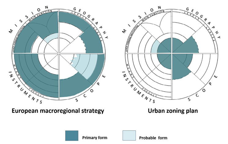
Fig. 3. Comparing radically different planning using the Map of Spatial Planning Forms
Source: own work.
To illustrate the visibility of sharp differences between traditional and new forms of planning on the Planning Map, one can take as an example the urban zoning plan and an international planning instrument, the European macro-regional strategies strategy, of which four have so far been adopted and are operational (Fig. 3). According to the EC definition, a macro-regional strategy (MRS) is an integrated framework endorsed by the European Council, which is applicable to Member States and third countries located in the same geographical area. These frameworks address common challenges and opportunities of their geographical area by setting shared, long-term objectives. The MRS are essentially cooperation frameworks that establish networks of stakeholders that represent a transnational, cross-sectorial mosaic of expertise with the potential for further cooperation, value, and prosperity creation. The aim is to improve institutional capacity by improving the ability to create innovative and inclusive services that can empower people and stakeholders, helping them actively contribute to the development of prosperous and open macro-regions in the medium to long term. It may be supported by the European Structural and Investment Funds (EC, 2022). The geography of these strategies includes multiple countries, and the main instruments are cooperation and partnership, while public investment is also relevant, and implementation may be supported by EU funds, which indicates how the related mission is closely linked to the goals of the European Union (social, economic, and territorial cohesion), as interpreted in a specific geographical area.
In contrast with this focus there are the local zoning plans used, which are utilised in most countries in different variations. These are typically used to define the limitations on the development activities (e.g., constructions) and land use changes of private and public actors (by setting up codes and land use change rules) and designate networks of public infrastructure, thereby ensuring public control of various actors. They use regulatory instruments and focus on physical consequences of development projects but might protect non-built-up areas and green spaces as well. Fig. 3 shows that the macro-regional strategy, which seems to be a very soft type of planning approach, while the features of an urban zoning plan are concentrated around the focal point. In terms of the four dimensions, there is no overlap between the former and the latter, and only a broad understanding of the international (European) spatial planning concept permits the consideration of both as forms of planning and the Planning Map helps to understand the differences between them.
To illustrate the use of the Planning Map for identifying more complex entities, the four ideal European planning models (or traditions) introduced in Chapter 2 can be taken as examples, the main characteristics of which are summarised in Table 2. When visualising more complex types – in contrast to a specific plan – the interpretation of forms might need more clarification of the meaning of the various forms. In this case the use categories might be needed to differentiate primary and probable forms, and possibly even more. In Fig. 4, one can see that Urbanism is obviously a more traditional, hard form of planning and Comprehensive integrated planning is closest to what new studies on new trends suggest. The use of the Planning Map in the case of planning systems of specific countries (or regions, cities) can also support the understanding of their relation also to the European ideal models.
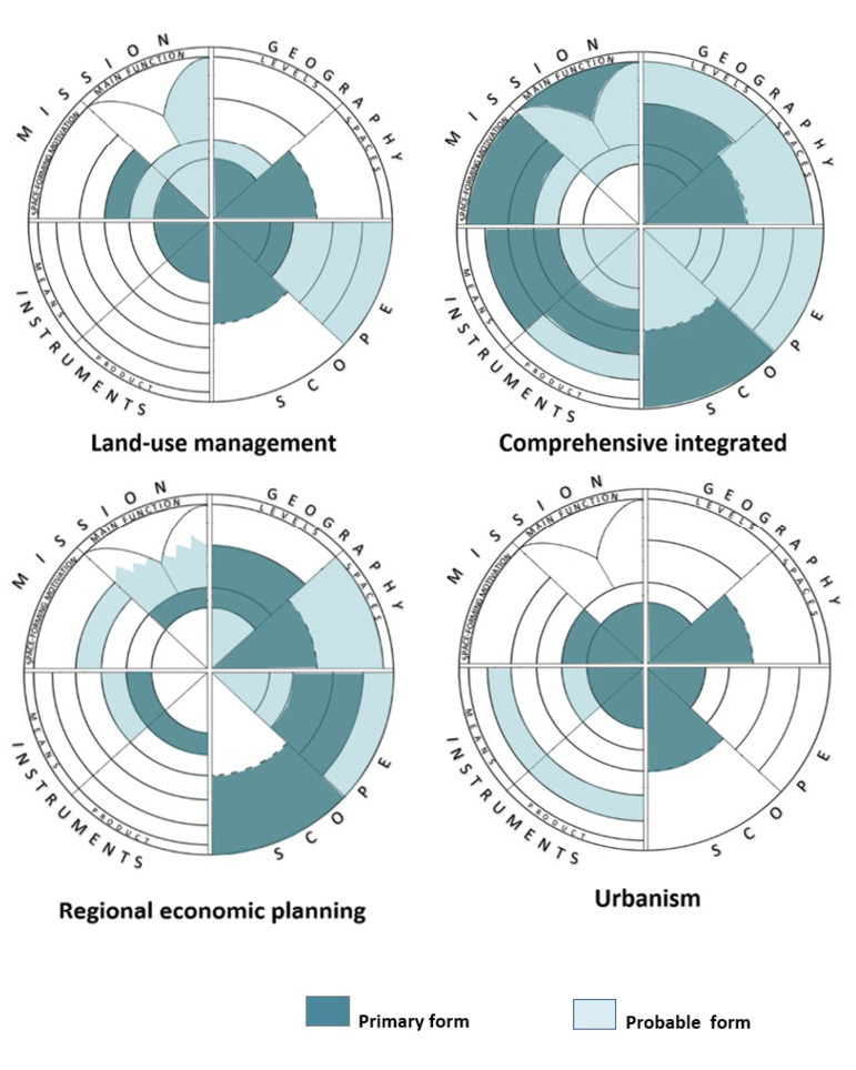
Fig. 4. Comparing the European ideal planning models (traditions) using the Map of Spatial Planning Forms
Source: own work *The European models were developed by the EU Compendium of Spatial Planning Systems and Policies (CEC, 1997), and the visualisation above is based on their description by Nadin and Stead (2013) (see Table 2).
| Regional economic planning | This regional economic planning tradition concerns “the pursuit of wide social and economic objectives, especially in relation to disparities in wealth, employment and social conditions between different regions of the country’s territory. Where this approach to planning is dominant, central government inevitably plays an important role in managing development pressures across the country and in undertaking public sector investment.” |
| Comprehensive integrated | In line with the comprehensive, integrated tradition, “spatial planning is conducted through a very systematic and formal hierarchy of plans from national to local level, which coordinate public sector activity across different sectors but focus more specifically on spatial coordination than economic development. This tradition is necessarily associated with mature systems. It requires responsive and sophisticated planning Institutions and mechanisms and considerable political commitment to the planning process. Public sector investment In bringing about the realization of the planning framework is also the norm.” |
| Land-use management | The land-use management tradition is “closely associated with the narrower task of controlling land use change at the strategic and local levels. In this situation, local authorities undertake most of the planning work, but the central administration is also able to exercise a degree of power, either through supervising the system [or by] setting central policy objectives.” |
| Urbanism | The urbanism tradition has “a strong architectural flavour and concern with urban design, townscape, and building control. In these cases regulation [is] undertaken through rigid zoning and codes There is a multiplicity of laws and regulations but the systems are not so well established, and [do not command] great political priority or general public support. As a result, they … [are] less effective [at] controlling development.” |
The Planning Map necessarily has several limitations. This approach lacks the identification of actors, stakeholder engagement processes, and most of the cultural elements of planning. It may provide only indirect information about the methods of planning (in the dimension of ‘Instruments’) and the relation of planning to other policies (in the ‘Mission’ dimension). It does not deliver direct information about the legal and institutional system, efficiency (distance between goals and outcomes), or the maturity of planning systems. However, as the method is not normative, it does not define any of the forms of planning as better or worse. Finally, as it is not connected to any planning ideology, it avoids the sensitive issue of making judgements in comparative research and is not appropriate for the normative evaluation of programmes. However, the proposed Planning Map seems to address the following challenges of comparative planning studies that were earlier listed:
In the paper, the Planning Map is illustrated using some rather abstract examples. According to the author’s experience this tool can be used efficiently in university education of planning to introduce rational and diversity-of spatial planning. However, its suitability can be demonstrated through its further practical application, and its further development can be ensured by its application to specific planning processes. The effectiveness of this comparative tool can be evaluated by using it either in comparative empirical research – on a large scale, or in case studies – or even for policy transfer and planning collaborative processes. Furthermore, the tool may be modified or developed further, supporting the identification of new spatial-planning ideal models that go beyond the four traditions identified in the Compendium.
Acknowledgments. This work was supported by the National Research, Development and Innovation Fund of Hungary under the Grant Tématerületi Kiválósági Program funding scheme [TKP2020-NKA-02].
The author is grateful to the following experts who supported the preparation of this work through their advice during his research since 2016: Antonic, Branislav (SRB, University of Belgrade), Balog, Zoltán (EC DG Empl), Blynth, Richard (UK, RTPI), Csák, László (RO, Babeș-Bólyai University), De Bruijn, Martijn (BE, Ruimte Vlaanderen, Spat. Development Dep. Flanders), Dühr, Stefanie (NL, DE, Nijmegen Radboud University), Faludi, Andreas (AT, NL, TUDelft, TUWien), Goodstand, Vincent (UK, RTPI), Németh, Sarolta (FI, Karelian Institute), Polomik, Helena (European Economic and Social Committee), Scheers, Joris (ECTP, BE, Catholic University of Leuven), Takáts, Péter (EC DG Regio), Zonneveld, Wil (NL, Technical University of Delft), and Péti, Márton (Corvinus University of Budapest).
ALLMENDINGER, P. (2000), Planning in Postmodern Times, London: Routledge.
ALLMENDINGER, P. (2016), ‘Towards a Post-Positivist Typology of Planning Theory’, Planning Theory, 1 (1), pp. 77–99. https://doi.org/10.1177/147309520200100105
ALLMENDINGER, P. and HAUGHTON, G. (2009), ’Soft spaces, fuzzy boundaries, and metagovernance: The new spatial planning in the Thames Gateway’, Environment and Planning A, 41 (3), pp. 617–633. https://doi.org/10.1068/a40208
ALLMENDINGER, P., HAUGHTON, G., KNIELING, J. and OTHENGRAFEN, F. (2015), Soft spaces of Europe. Re-negotiating governance, boundaries and borders, Oxon: Routledge. https://doi.org/10.4324/9781315768403
ASSCHE, K., BEUNEN, R. and VERWEIJ, S. (2020), ‘Comparative Planning Research, Learning, and Governance: The Benefits and Limitations of Learning Policy by Comparison’, Urban Planning, 5 (1), pp. 11–21. https://doi.org/10.17645/up.v5i1.2656
BERISHA, E., COTELLA, G., JANIN RIVOLIN, U. and SOLLY, A. (2021), ‘Spatial governance and planning systems in the public control of spatial development: a European typology’, European Planning Studies, 29 (1), pp. 181–200. https://doi.org/10.1080/09654313.2020.1726295
BÖHME, K. (2002), Nordic Echoes of European Spatial Planning: Discursive Integration in Practice, Stockholm: Nordregio, https://repository.ubn.ru.nl/bitstream/handle/2066/19205/19205_nordecofe.pdf?sequence=1&isAllowed=y [accessed on: 10.10.2022].
BÖHME, K. and WATERHOUT, B. (2008), ‘The Europeanization of Planning’, [in:] FALUDI, A. (ed.), European Spatial Research and Planning, Cambridge, Massachusetts: Lincoln Institute of Land Policy, pp. 225–248.
CEC (1997), The EU Compendium of Spatial Planning Systems and Policies, Luxembourg: Office for Official Publications of the European Communities.
COTELLA, G. and JANIN RIVOLIN, U. (2011), ‘Europeanization of Spatial Planning through Discourse and Practice in Italy’, disP – The Planning Review, 47 (186), pp. 42–53. http://doi.org/10.1080/02513625.2011.10557143
DALLHAMMER, E., GAUGITSCH, R., NEUGEBAUER, W. and BÖHME, K. (2018), Spatial planning and governance within EU policies and legislation and their relevance to the New Urban Agenda, Brussels: European Committee of the Regions, https://cor.europa.eu/en/engage/studies/Documents/Spatial-planning-new-urban-agenda.pdf [accessed on: 10.02.2023].
DAVIES, H. W. E. (ed.) (1989), Planning Control in Western Europe, London: HMSO.
DÜHR, S., COLOMB, C. and NADIN, V. (2010), European Spatial Planning and Territorial -Cooperation, London and New York: Routledge. https://doi.org/10.4324/9780203895290
European Commission (2022), Report from the Commission to the European Parliament, the Council, the European Economic And Social Committee and the Committee of the Regions on the implementation of EU macro-regional strategies, Brussels: European Commission, https://eur-lex.europa.eu/legal-content/EN/TXT/HTML/?uri=CELEX:52022DC0705&from=EN [accessed on: 10.02.2023].
ERNSTE, H. (2012), ‘Framing Cultures of Spatial Planning’, Planning Practice and Research, 27(1), pp. 87–101. https://doi.org/10.1080/02697459.2012.661194
ESPON (2018), COMPASS – Comparative Analysis of Territorial Governance and Spatial Planning Systems in Europe, Final Report, Luxembourg: ESPON, https://www.espon.eu/sites/default/files/attachments/1.%20COMPASS_Final_Report.pdf [accessed on: 10.10.2022].
ESPON (2013): TANGO – Territorial Approaches for New Governance, Final Report, Luxembourg: ESPON, https://www.espon.eu/sites/default/files/attachments/ESPON_TANGO_Executive_summary_Final.pdf [accessed on: 10.02.2023].
EU MINISTERS (2020), The New Leipzig Charter – The transformative power of cities for the common good, adopted at the Informal Ministerial Meeting on Urban Matters on 30 November Germany.
FALUDI, A. (2004), ‘Spatial Planning Traditions in Europe: Their Role in the ESDP Process’, International Planning Studies, 9 (2–3), pp. 155–172. https://doi.org/10.1080/1356347042000311758
FALUDI, A. and WATERHOUT, B. (2002), The Making of the European Spatial Development Perspective: No Masterplan, London: Routledge.
FALUDI, A. (2011), ‘Cohesion, Coherence, Cooperation: European Spatial Planning Coming of Age?’, RTPI Library Series, Oxon: Routledge. https://doi.org/10.4324/9780203842324
FALUDI, A. (2013), ‘Territorial cohesion, territorialism, territoriality, and soft planning: a critical review’, Environment and Planning A, 45 (6), pp. 1302–1317. https://doi.org/10.1068/a45299
FALUDI, A. (2016), ‘Territorial governance challenging government’, [in:] SCHMITT, P. and VAN WELL L. (eds.), Territorial governance across Europe. Pathways, practices and prospects, London: Routledge, pp. 27–39. https://doi.org/10.4324/9781315716220
FARINÓS DASÍ, J. (ed.) (2006), ESPON project 2.3.2 Governance of Territorial and Urban Policies from EU to Local Level, Final Report, Luxembourg: ESPON. https://www.espon.eu/sites/default/files/attachments/fr-2.3.2_final_feb2007.pdf [accessed on: 10.02.2023].
FRANK, A., MIRONOWICZ, A., LOURENÇO, J., FRANCHINI, T., ACHE, P., FINKA, M., SCHOLL, B. and GRAMS, A. (2014), ‘Educating planners in Europe: A review of 21st century study programmes’, Progress in Planning, 91, pp. 30–94. https://doi.org/10.1016/j.progress.2013.05.001
FÜRST, D. (2009), ‘Planning Cultures on route to a better comprehension of «planning process»?’, [in:] KNIELING, J. and OTHENGRAFEN, F. (eds.), Planning cultures in Europe: Decoding Cultural Phenomena in Urban and Regional Planning, Rarnham: Ashgate, pp. 23–38. https://doi.org/10.4324/9781315246727
GÄNZLE, S. and KERN, K. (eds.) (2016), A ’Macro-regional’ Europe in the making: Theoretical Approaches and Empirical Evidence, Houndmills: Palgrave Macmillan. https://doi.org/10.1007/978-1-137-50972-7
GETIMIS, P. (2012), ‘Comparing Spatial Planning Systems and Planning Cultures in Europe. The Need for a Multi-scalar Approach’, Planning Practice and Research, 27 (1), pp. 25–40. https://doi.org/10.1080/02697459.2012.659520
Harrison, J., Galland, D. and Tewdwr-Jones, M. (2020), ‘Regional planning is dead: Long live planning regional futures’, Regional Studies, 55 (1), pp. 6–18, https://doi.org/10.1080/00343404.2020.1750580
HAUGHTON, G., ALLMENDINGER, P., COUNSELL, D. and VIGAR, G. (2010), The New Spatial Planning. Territorial Management with Soft Spaces and Fuzzy Boundaries, London: Routledge. https://doi.org/10.4324/9780203864425
HELEY, J. (2013), ‘Soft spaces, fuzzy boundaries and spatial governance in post devolution Wales’, International Journal of Urban and Regional Research, 37 (4), pp. 1325–1348. https://doi.org/10.1111/j.1468-2427.2012.01149.x
JANIN RIVOLIN, U. (2012), ‘Planning Systems as Institutional Technologies: a Proposed Conceptualization and the Implications for Comparison’, Planning Practice and Research, 27 (1), pp. 63-85. https://doi.org/10.1080/02697459.2012.661181
KNIELING, J. and OTHENGRAFEN, F. (2016), ‘EN route to a theoretical model for comparative research on planning cultures’, [in:] KNIELING, J. and OTHENGRAFEN, F. (eds.), Planning cultures in Europe. Decoding cultural phenomena in urban and regional planning, London, New York: Routledge. https://doi.org/10.4324/9781315246727
KUNZMANN, K. (2006), ‘The Europeanisation of spatial Planning’ [in:] ADAMS, N., ALDEN, J. and HARRIS, N. (eds.), Regional development and spatial planning in an enlarged European Union, Hamshire: ASHGATE.
LARSSON, G. (2006), Spatial planning systems in Western Europe, Amsterdam: Ios Press.
METZGER, J. and SCHMITT, P. (2012), ‘When soft spaces harden: The EU strategy for the Baltic Sea Region’, Environment and Planning A, 44 (2), pp. 263–280. https://doi.org/10.1068/a44188
NADIN, V. (2006), The Role and Scope of Spatial Planning – Literature Review Spatial Plans in Practice Supporting the Reform of Spatial Planning, London: Department for Communities and Local Government.
NADIN, V. (2012), ‘International comparative planning methodology: Introduction to the theme issue’, Planning Practice and Research, 27 (1), pp. 1–5. https://doi.org/10.1080/02697459.2012.669928
NADIN, V. and STEAD, D. (2012), ‘European Spatial Planning Systems, Social Models and Learning’, disP – The Planning Review, 44 (172), pp. 35–47. https://doi.org/10.1080/02513625.2008.10557001
NADIN, V. and STEAD, D. (2013), ‘Opening up the Compendium: An evaluation of international comparative planning research methodologies’, European Planning Studies, 21 (10), pp. 1542–1561. https://doi.org/10.1080/09654313.2012.722958
Nadin, V., Stead, D., Dabrowski, M. and Fernandez-Maldonado, A. M. (2021), ‘Integrated, adaptive and participatory spatial planning: Trends across Europe’, Regional Studies, 55 (5), pp. 791–803. https://doi.org/10.1080/00343404.2020.1817363
NEWMAN, P. and THORNLEY, A. (1996), Urban planning in Europe: International competition, national systems, and planning projects, London: Routledge.
OTHENGRAFEN, F. (2016), Uncovering the Unconscious Dimensions of Planning: Using Culture as a Tool to Analyse Spatial Planning Practices, Oxon: Ashgate. https://doi.org/10.4324/9781315549347
OTHENGRAFEN, F. and GALLAND, D. (2019), ‘International Comparative Planning’ [in:] Leigh, N. G., French, S. P., Guhathakurta, S. and Stiftel, B. (eds.), The Routledge Handbook of International Planning Education, Routledge. https://doi.org/10.4324/9781315661063
PERIĆ, A., TRKULJA, S. and ŽIVANOVIĆ, Z. (2021), ‘From conformance to performance? A comparative analysis of the European Union territorial policy trends in Serbia and Bosnia and Herzegovina’, European Spatial Research and Policy, 28 (2), pp. 21–41. https://doi.org/10.18778/1231-1952.28.2.02
PÉTI, M. (2011), A területi tervezés és fejlesztés a fenntarthatóság jegyében & stratégiai környezeti vizsgálatok földrajzi szemlélettel, Szeged: JATEPress Kiadó, http://acta.bibl.u-szeged.hu/45347/1/ft_007.pdf [accessed on: 10.02.2023].
PURKARTHOFER, E. (2016), ‘When soft planning and hard planning meet: Conceptualiszing the encounter of European, national and sub-national planning’, European Journal of Spatial Development, 61, pp. 1–20, https://archive.nordregio.se/Global/EJSD/Refereed%20articles/Refereed61.pdf [accessed on: 10.02.2023].
Purkarthofer, E., Humer, A. and Mantysalo, R. (2021), ‘Regional planning: An arena of interests, institutions and relations’, Regional Studies, 55 (5), pp. 773–777. https://doi.org/10.1080/00343404.2021.1875128
REIMER, M. and BLOTEVOGEL, H. H. (2012), ‘Comparing spatial planning practice in Europe: A plea for cultural sensitization’, Planning Practice and Research, 27 (1), pp. 7–24. https://doi.org/10.1080/02697459.2012.659517
REIMER, M., PANAGIOTIS, G. and BLOTEVOGEL, H. H. (eds.) (2014a), Spatial planning systems and practices in Europe, New York, Oxon: Routledge. https://doi.org/10.4324/9781315852577
REIMER, M., PANAGIOTIS, G. and BLOTEVOGEL, H. H. (2014b), ‘Conclusion: multiple trends of continuity and change’, [in:] REIMER, M., GETIMIS, P.,and BLOTEVOGEL, H. (eds.), (eds.), Spatial planning systems and practices in Europe, New York, Oxon: Routledge.
SALAMIN, G. (2018), A földrajzi tér alakításának európaizálódása: Az Európai Unió térbeli stratégiáinak, tervezésének és kohéziós politikájának hatása az európai országok térbeli tervezési rendszereinek transzformációjára (Unpublished doctoral dissertation), Gödöllő: Szent István University.
SALAMIN, G. and PÉTI, M. (2019), ‘Tervkészítéstől a governance-ig: A térbeli tervezés európai fogalma, jelentései és lehetséges hazai kapcsolódásai’, Tér és Társadalom, 33 (3), pp. 7–28. https://doi.org/10.17649/TET.33.3.3175
SALAMIN, G. (2019), ‘European Trends in Planning - Lessons From a Survey on Changes of Spatial Planning’ (presentation and conference paper), [in:] Planning on the Edge: 13th Biennial of European Towns and Town Planners, 11 to 13 September 2019, Plymouth, UK: Plymouth University, pp. 46-47, https://www.plymouth.ac.uk/uploads/production/document/path/15/15367/13th_European_Biennial_of_Towns_and_Town_Planners_2019_Final_Programme.pdf [accessed on: 10.02.2023].
SALAMIN, G. (2021), ‘Ki a tervező?: A területi és várostervezés (térbeli tervezés) mint szakma és diszciplína Európában’, [in:] SALAMIN, G. and TÓTH, B. (eds.), Városok – tervezés – ingatlanpiac : Az urbanisztika aktuális kérdései, Budapest, HU: Magyar Urbanisztikai Társaság, pp. 13-28.
SERVILLO, L. A. and BROECK, P. V. D (2012), ‘The social construction of planning systems: A strategic-relational institutionalist approach’, Planning Practice and Research, 27 (1), pp. 41–61. https://doi.org/10.1080/02697459.2012.661179
SMAS, L. and SCHMITT, P. (2021), ‘Positioning regional planning across Europe’, Regional Studies, 55 (5), pp. 778–790. https://doi.org/10.1080/00343404.2020.1782879
STEAD, D. (2013), ‘Convergence, Divergence, or Constancy of Spatial Planning? Connecting Theoretical Concepts with Empirical Evidence from Europe’, Journal of Planning Literature, 28 (1), pp. 19–31. https://doi.org/10.1177/0885412212471562
STEAD, D. and COTELLA, G. (2012), ‘Differential Europe: Domestic Actors and Their Role in Shaping Spatial Planning Systems’, disP – The Planning Review, 47 (186), pp. 13–21. https://doi.org/10.1080/02513625.2011.10557140
STEAD, D. and PÁLNÉ KOVÁCS, I. (2016), ‘Shifts in governance and government across Europe’, [in:] SCHMITT, P. and VAN WELL, L. (eds.), Territorial governance across Europe. Pathways, practices and prospects, London: Routledge, pp. 11–26. https://doi.org/10.4324/9781315716220
SÜTŐ, A., SZABÓ, P. and SALAMIN, G. (2010), ‘Issues of Territoriality and Territorial Cohesion in the Revision of the TSP and the Territorial Agenda – a Sort of Connection between Geography and Regional Policy’, Forum Geografic, 9 (9), pp. 145–154. https://forumgeografic.ro/wp-content/uploads/2010/9/Suto.pdf [accessed on: 10.02.2023].
TEWDWR-JONES, M. (2001), ‘Complexity and Interdependency in a caleidoscopic Spatial Planning Landscape for Europe’, [in:] ALBRECHTS, L. (ed.), The Changing Institutional Landscape of Planning, Aldershot: Ashgate Publishing Ltd.
VAN WELL, L. and SCHMITT, P. (2016), ‘Territorial governance across Europe’, [in:] SCHMITT, P. and VAN WELL, L. (eds.), Territorial governance across Europe. Pathways, practices and prospects, London: Routledge, pp. 5–11. https://doi.org/10.4324/9781315716220
VERWEIJ, S. and TRELL, E. M. (2019), ‘Qualitative comparative analysis (QCA) in spatial planning research and related disciplines: A systematic literature review of applications’, Journal of Planning Literature, 34 (3), pp. 300–317. https://doi.org/10.1177/0885412219841490
WALSH, C. (2014), ‘Rethinking the spatiality of spatial planning: methodological territorialism and metageographies’, European Planning Studies, 22 (2), pp. 306–322. https://doi.org/10.1080/09654313.2012.741568
WILLIAMS, R. H. (1996), European Union Spatial Policy and Planning, London: Paul Chapman.
Zimmerbauer, K. and Paasi, A. (2019), ‘Hard work with soft spaces (and vice versa): probelmatizing the transformating planning spaces’, European Planning Studies, 28 (4), pp. 771–789. https://doi.org/10.1080/09654313.2019.1653827